Box Elder Creek (Colorado)

Last updated
Box Elder Creek [1]
Box Elder Creek (Colorado).JPG
The creek as it passes under Interstate 76
South Platte basin map.png
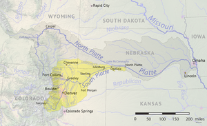
South Platte tributaries, including Box Elder Creek
Location
Physical characteristics
Source 
 - coordinates 39°30′06″N104°33′40″W / 39.50167°N 104.56111°W / 39.50167; -104.56111
Mouth  
 - location
Confluence with the South Platte
 - coordinates
40°22′28″N104°28′02″W / 40.37444°N 104.46722°W / 40.37444; -104.46722 Coordinates: 40°22′28″N104°28′02″W / 40.37444°N 104.46722°W / 40.37444; -104.46722
 - elevation
4,554 ft (1,388 m)
Basin features
Progression South PlattePlatte
MissouriMississippi

Box Elder Creek is a tributary that joins the South Platte River near Kersey, Colorado. It rises in Elbert County, Colorado.

Tributary stream or river that flows into a main stem river or lake

A tributary or affluent is a stream or river that flows into a larger stream or main stem river or a lake. A tributary does not flow directly into a sea or ocean. Tributaries and the main stem river drain the surrounding drainage basin of its surface water and groundwater, leading the water out into an ocean.

South Platte River principal tributary of the Platte River

The South Platte River is one of the two principal tributaries of the Platte River. Flowing through the U.S. states of Colorado and Nebraska, it is itself a major river of the American Midwest and the American Southwest/Mountain West. Its drainage basin includes much of the eastern flank of the Rocky Mountains in Colorado; much of the populated region known as the Colorado Front Range and Eastern Plains; and a portion of southeastern Wyoming in the vicinity of the city of Cheyenne. It joins the North Platte River in western Nebraska to form the Platte, which then flows across Nebraska to the Missouri. The river serves as the principal source of water for eastern Colorado. In its valley along the foothills in Colorado, it has permitted agriculture in an area of the Colorado Piedmont and Great Plains that is otherwise arid.

Kersey, Colorado Statutory Town in Colorado, United States

The Town of Kersey is a Statutory Town in Weld County, Colorado, United States. The population was 1454 at the 2010 United States Census.

The creek flows through Elbert, Arapahoe, Adams, and Weld counties. It passes near Denver International Airport.

Elbert County, Colorado County in the United States

Elbert County is one of the 64 counties of the U.S. state of Colorado. As of the 2010 census, the population was 23,086. The county seat is Kiowa.

Arapahoe County, Colorado County in the United States

Arapahoe County is one of the 64 counties in the U.S. state of Colorado. As of the 2010 census, the population was 572,003, making it the third-most populous county in Colorado. The county seat is Littleton, and the most populous city is Aurora. The county was named for the Arapaho Native American tribe who once lived in the region.

Adams County, Colorado County in the United States

Adams County is the fifth-most populous of the 64 counties of the U.S. state of Colorado. As of the 2010 census, the population was 441,603. The county seat is Brighton. The county is named for Alva Adams, Governor of the State of Colorado.

See also

Related Research Articles

Douglas County, Colorado County in the United States

Douglas County is the seventh-most populous of the 64 counties of the U.S. state of Colorado. As of the 2010 census, the population was 285,465. The county seat is Castle Rock.

Box Elder County, Utah County in the United States

Box Elder County is a county at the northwestern corner of Utah, United States. As of 2017, the estimated population is 54,079. Its county seat and largest city is Brigham City. The county was named for the box elder trees that abound in the county.

Lincoln County, Colorado County in the United States

Lincoln County is one of the 64 counties in the U.S. state of Colorado. As of the 2010 census, the population was 5,467. The county seat is Hugo. The county obtains its name in memory of President Abraham Lincoln.

Cheyenne County, Colorado County in the United States

Cheyenne County is the sixth-least densely populated of the 64 counties of the U.S. state of Colorado. The county population was 1,836 at 2010 census. The county seat is Cheyenne Wells.

Mount Elbert highest mountain in the US state of Colorado

Mount Elbert is the highest summit of the Rocky Mountains of North America and the highest point in the U.S. state of Colorado and the entire Mississippi River drainage basin. The ultra-prominent 14,440-foot (4401.2 m) fourteener is the highest peak in the Sawatch Range and the second-highest summit in the contiguous United States after Mount Whitney. Mount Elbert is located in San Isabel National Forest, 12.1 miles (19.4 km) southwest of the City of Leadville in Lake County, Colorado.

Box Elder or Boxelder may refer to:

Sawatch Range mountain range

The Sawatch Range is a high and extensive mountain range in central Colorado which includes eight of the twenty highest peaks in the Rocky Mountains, including Mount Elbert, at 14,440 feet (4,401 m) elevation, the highest peak in the Rockies.

Pyramid Peak (Colorado) Mountain Peak in Colorado

Pyramid Peak is a fourteen thousand foot mountain in the U.S. state of Colorado. It is the 47th highest mountain peak in Colorado, and 78th highest peak in the United States. It is located in the Elk Mountains in southeastern Pitkin County, approximately 12 miles (19 km) southwest of Aspen. The summit somewhat resembles a ragged square pyramid and is visible from the Roaring Fork River valley north of Aspen along the canyon of Maroon Creek.

Rio Chama

The Rio Chama, a major tributary river of the Rio Grande, is located in the U.S. states of Colorado and New Mexico. The river is about 130 miles (210 km) long altogether. From its source to El Vado Dam its length is about 50 miles (80 km), from El Vado Dam to Abiquiu Dam is about 51 miles (82 km), and from Abiquiu Dam to its confluence with the Rio Grande is about 34 miles (55 km).

Elbert, Colorado Census-designated place in Colorado, United States

Elbert is a census-designated place (CDP) and the location of a U.S. post office in Elbert County, Colorado, United States. Although it is unincorporated, Elbert has a post office with the ZIP code 80106. As of the 2010 census it had a population of 230.

Agate, Colorado Unincorporated community in State of Colorado, United States

Agate is an unincorporated community and U.S. Post Office in Elbert County, Colorado, United States. The ZIP Code of the Agate Post Office is 80101.

Granite, Colorado Unincorporated community in Colorado, United States

Granite is an unincorporated community with a U.S. Post Office in Chaffee County, Colorado, United States. The zip code of Granite is 81228. According to the 2010 census, the population is 116.

Battle of Brier Creek Battle of the American Revolutionary War

The Battle of Brier Creek was an American Revolutionary War battle fought on March 3, 1779 near the confluence of Brier Creek with the Savannah River in eastern Georgia. A Patriot force consisting principally of militia from North Carolina and Georgia was surprised, suffering significant casualties. The battle occurred only a few weeks after a resounding American Patriot victory over a Loyalist militia at Kettle Creek, north of Augusta, reversing its effect on morale.

The Broad River is a 60.0-mile-long (96.6 km) tributary of the Savannah River in northeastern Georgia. The North Fork of the Broad River begins in the foothills of the Appalachian Mountains in Stephens County, then joins the Middle Fork west of Royston in Franklin County to form the main stem. The Broad River continues south, being joined by the Hudson River flowing from the west out of Franklin County. The Broad was used for reference as the county line between Madison and Elbert counties as it turns southeast.

Big Sandy Creek (Colorado) river in Colorado, United States of America

Big Sandy Creek is a 211-mile-long (340 km) tributary of the Arkansas River noted for being the location of the Sand Creek Massacre in Kiowa County. Long stretches are dry most of the time on the surface, although water still flows underground. Big Sandy Creek starts near Peyton in El Paso County, Colorado and flows through Elbert, Lincoln, Cheyenne and Kiowa counties before it joins with the Arkansas River in Prowers county east of Lamar.

Beaver Creek is a 165-mile-long (266 km) tributary of the South Platte River in Colorado. The creek flows from a source in Elbert County to a confluence with the South Platte in Morgan County near Hillrose.


The Hungate massacre involved the murder of the family of Nathan Hungate along Running Creek on June 11, 1864. It was a precipitating factor leading to the Sand Creek massacre of November 29, 1864.

The Rush Creek Wind Project is a 600 megawatt (MW) wind facility in eastern Colorado, located south of the town of Limon. It increased the wind generating capacity in the state by 20% when it came online in late 2018. The facility is financed, owned, and operated by Xcel Energy, the largest public utility in the state. The project was developed primarily for its numerous economic benefits since Xcel previously met the minimum 30% requirement of Colorado's 2020 renewable portfolio standard.

References

  1. "Box Elder Creek". Geographic Names Information System . United States Geological Survey . Retrieved 2015-04-25.