Boxford (CDP), Massachusetts

Last updated

Boxford, Massachusetts
Holyoke French House.JPG
Holyoke French House
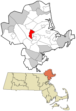
Essex County Massachusetts incorporated and unincorporated areas Boxford (CDP) highlighted.svg
Location in Essex County and the state of Massachusetts.
Coordinates: 42°40′25″N70°59′10″W / 42.67361°N 70.98611°W / 42.67361; -70.98611
Country United States
State Massachusetts
County Essex
Area
[1]
  Total5.47 sq mi (14.18 km2)
  Land5.36 sq mi (13.89 km2)
  Water0.11 sq mi (0.28 km2)
Elevation
102 ft (31 m)
Population
 (2020)
  Total2,432
  Density453.39/sq mi (175.05/km2)
Time zone UTC-5 (Eastern (EST))
  Summer (DST) UTC-4 (EDT)
ZIP code
01921
Area code 978
FIPS code 25-07385
GNIS feature ID0614204

Boxford is a census-designated place (CDP) in the town of Boxford in Essex County, Massachusetts, United States. The population was 2,339 at the 2010 census. [2]

Contents

Geography

According to the United States Census Bureau, the CDP has a total area of 5.5 square miles (14.2 km2), of which 5.4 square miles (13.9 km2) is land and 0.12 square miles (0.3 km2) (1.99%) is water. [3]

Demographics

Historical population
CensusPop.Note
2020 2,432
U.S. Decennial Census [4]

As of the census of 2000, there were 2,340 people, 756 households, and 674 families residing in the CDP. The population density was 164.0/km2 (424.8/mi2). There were 765 housing units at an average density of 53.6 inhabitants/km2 (138.9 inhabitants/mi2). The racial makeup of the CDP was 96.84% White, 0.34% African American, 1.37% Asian, 0.00% Pacific Islander, 0.47% from other races, and 0.98% from two or more races. 0.98% of the population were Hispanic or Latino of any race.

There were 756 households, out of which 47.4% had children under the age of 18 living with them, 80.4% were married couples living together, 6.6% have a woman whose husband does not live with her, and 10.8% were non-families. 7.9% of all households were made up of individuals, and 3.2% had someone living alone who was 65 years of age or older. The average household size was 3.10 and the average family size was 3.29.

In the CDP, the population was spread out, with 31.3% under the age of 18, 4.1% from 18 to 24, 26.2% from 25 to 44, 27.5% from 45 to 64, and 10.9% who were 65 years of age or older. The median age was 40 years. For every 100 females, there were 99.5 males. For every 100 females age 18 and over, there were 95.1 males.

The median income for a household in the CDP was $108,778, and the median income for a family was $116,810. Males had a median income of $72,426 versus $38,073 for females. The per capita income for the CDP was $51,977. None of the families and 1.0% of the population were below the poverty line. Out of the total people living in poverty, 0.0% are under the age of 18 and 5.1% are 65 or older.

Related Research Articles

<span class="mw-page-title-main">Heber, California</span> American census-designated place

Heber is a census-designated place (CDP) in Imperial County, California. Heber is located 4.5 miles (7 km) north-northwest of Calexico. The population was 4,275 at the 2010 census, up from 2,566 in 2000.
<span class="mw-page-title-main">Monument Beach, Massachusetts</span> Census-designated place in Massachusetts, United States

Monument Beach is a census-designated place (CDP) in the town of Bourne in Barnstable County, Massachusetts, United States. The population was 2,790 at the 2010 census.

<span class="mw-page-title-main">West Concord, Massachusetts</span> Census-designated place in Massachusetts, United States

West Concord is an unincorporated village and census-designated place (CDP) in the town of Concord in Middlesex County, Massachusetts, United States. The population was 6,320 at the 2020 census.

<span class="mw-page-title-main">Sewaren, New Jersey</span> Populated place in Middlesex County, New Jersey, US

Sewaren is an unincorporated community and census-designated place (CDP) within Woodbridge Township, in Middlesex County, in the U.S. state of New Jersey. As of the 2010 United States Census, the CDP's population was 2,756.

<span class="mw-page-title-main">Brewster Hill, New York</span> Census-designated place in New York, United States

Brewster Hill is a hamlet located in the town of Southeast in Putnam County, New York, United States. As of the 2010 census, the population was 2,089.

<span class="mw-page-title-main">Royal Pines, North Carolina</span> Census-designated place in North Carolina, United States

Royal Pines is a census-designated place (CDP) in Buncombe County, North Carolina, United States. The population was 4,272 at the 2010 census. It is part of the Asheville Metropolitan Statistical Area.

<span class="mw-page-title-main">Four Corners, Oregon</span> Unincorporated community in the state of Oregon, United States

Four Corners is a census-designated place (CDP) in Marion County, Oregon, United States, just outside the city limits of Salem but within the city's urban growth boundary. It is part of the Salem Metropolitan Statistical Area. The population of the CDP was 16,740 at the 2020 census. It is named after the intersection of State Street and Lancaster Drive.

Oneida is a census-designated place (CDP) in Schuylkill County, Pennsylvania. The population was 219 at the 2000 census.

<span class="mw-page-title-main">Bourne (CDP), Massachusetts</span> Census-designated place in Massachusetts, United States

The village of Bourne is a census-designated place (CDP) in the town of Bourne in Barnstable County, Massachusetts, United States. The population was 1,418 at the 2010 census, out of 19,754 in the town of Bourne as a whole.

<span class="mw-page-title-main">Brewster (CDP), Massachusetts</span> Census-designated place in Massachusetts, United States

Brewster is a census-designated place (CDP) in the town of Brewster in Barnstable County, Massachusetts, United States. The population was 2,000 at the 2010 census, out of 9,820 in the town of Brewster as a whole.

<span class="mw-page-title-main">Chatham (CDP), Massachusetts</span> Census-designated place in Massachusetts, United States

Chatham is a census-designated place (CDP) in the town of Chatham in Barnstable County, Massachusetts, United States. The population was 1,421 at the 2010 census, out of 6,125 in the entire town of Chatham.
<span class="mw-page-title-main">Falmouth (CDP), Massachusetts</span> Census-designated place in Massachusetts, United States

Falmouth is a census-designated place (CDP) consisting of the primary settlement in the town of Falmouth in Barnstable County, Massachusetts, United States. The population of the CDP was 3,799 at the 2010 census, out of 31,532 in the town as a whole. It was named after Falmouth, Cornwall, England.

<span class="mw-page-title-main">Orleans (CDP), Massachusetts</span> Census-designated place in Massachusetts, United States

Orleans is a census-designated place (CDP) in the town of Orleans in Barnstable County, Massachusetts, United States. The population was 1,621 at the 2010 census.

<span class="mw-page-title-main">Adams (CDP), Massachusetts</span> Census-designated place in Massachusetts, United States

Adams is a census-designated place (CDP) located in the town of Adams in Berkshire County, Massachusetts, United States. The population was 5,515 at the 2010 census, out of 8,485 in the entire town of Adams.

<span class="mw-page-title-main">Andover (CDP), Massachusetts</span> Census-designated place in Massachusetts, United States

Andover is a census-designated place (CDP) in the town of Andover in Essex County, Massachusetts, United States. The population was 8,762 at the 2010 census.

<span class="mw-page-title-main">Rockport (CDP), Massachusetts</span> Census-designated place in Massachusetts, United States

Rockport is a census-designated place (CDP) in the town of Rockport in Essex County, Massachusetts, United States. The population was 4,966 at the 2010 census.

<span class="mw-page-title-main">Salisbury (CDP), Massachusetts</span> Census-designated place in Massachusetts, United States

Salisbury is a census-designated place (CDP) in the town of Salisbury in Essex County, Massachusetts, United States. The population was 4,869 at the 2010 census.

<span class="mw-page-title-main">Pepperell (CDP), Massachusetts</span> Census-designated place in Massachusetts, United States

Pepperell is a census-designated place (CDP) comprising the main village in the town of Pepperell in Middlesex County, Massachusetts, United States. The population was 2,390 at the 2020 census, out of 11,604 in the entire town of Pepperell.
<span class="mw-page-title-main">Shirley (CDP), Massachusetts</span> Census-designated place in Massachusetts, United States

Shirley is a census-designated place (CDP) comprising the main village in the town of Shirley in Middlesex County, Massachusetts, United States. The population was 1,611 at the 2020 census, out of 7,431 in the entire town of Shirley.

Hartland is a census-designated place (CDP) in the town of Hartland in Somerset County, Maine, United States. The population was 756 at the 2020 census.

References

  1. "2020 U.S. Gazetteer Files". United States Census Bureau. Retrieved May 21, 2022.
  2. "Profile of General Population and Housing Characteristics: 2010 Demographic Profile Data (DP-1): Boxford CDP, Massachusetts". United States Census Bureau . Retrieved September 6, 2012.
  3. "Geographic Identifiers: 2010 Demographic Profile Data (G001): Boxford CDP, Massachusetts". United States Census Bureau . Retrieved September 6, 2012.
  4. "Census of Population and Housing". Census.gov. Retrieved June 4, 2016.