Ipswich (CDP), Massachusetts

Last updated
Ipswich, Massachusetts
Choate Bridge, Ipswich MA.jpg
Choate Bridge
Essex County Massachusetts incorporated and unincorporated areas Ipswich (CDP) highlighted.svg
Location in Essex County and the state of Massachusetts.
Coordinates: 42°40′46″N70°50′16″W / 42.67944°N 70.83778°W / 42.67944; -70.83778 Coordinates: 42°40′46″N70°50′16″W / 42.67944°N 70.83778°W / 42.67944; -70.83778
Country United States
State Massachusetts
County Essex
Area
[1]
  Total1.74 sq mi (4.51 km2)
  Land1.64 sq mi (4.25 km2)
  Water0.10 sq mi (0.27 km2)
Elevation
26 ft (8 m)
Population
 (2020)
  Total4,370
  Density2,666.26/sq mi (1,029.23/km2)
Time zone UTC-5 (Eastern (EST))
  Summer (DST) UTC-4 (EDT)
ZIP code
01938
Area code(s) 978
FIPS code 25-32275
GNIS feature ID0614554

Ipswich is a census-designated place (CDP) located in the town of Ipswich in Essex County, Massachusetts, United States. The population was 4,222 at the 2010 census. [2]

Contents

Geography

According to the United States Census Bureau, the CDP has a total area of 1.75 square miles (4.52 km2), of which 1.64 square miles (4.25 km2) is land and 0.10 square miles (0.26 km2) (5.80%) is water. [3]

Demographics

Historical population
CensusPop.
2020 4,370
U.S. Decennial Census [4]

As of the census of 2000, there were 4,161 people, 1,841 households, and 994 families residing in the CDP. The population density was 967.8/km2 (2,508.1/mi2). There were 1,923 housing units at an average density of 447.3 inhabitants/km2 (1,159.1 inhabitants/mi2). The racial makeup of the CDP was 96.78% White, 0.38% African American, 0.14% Native American, 0.99% Asian, 0.55% from other races, and 1.15% from two or more races. Hispanic or Latino of any race were 1.11% of the population.

There were 1,841 households, out of which 28.0% had children under the age of 18 living with them, 39.7% were married couples living together, 10.8% have a woman whose husband does not live with her, and 46.0% were non-families. 38.0% of all households were made up of individuals, and 14.7% had someone living alone who was 65 years of age or older. The average household size was 2.23 and the average family size was 3.01.

In the CDP, the population was spread out, with 22.2% under the age of 18, 6.3% from 18 to 24, 32.8% from 25 to 44, 22.7% from 45 to 64, and 16.1% who were 65 years of age or older. The median age was 39 years. For every 100 females, there were 88.8 males. For every 100 females age 18 and over, there were 84.5 males.

The median income for a household in the CDP was $40,482, and the median income for a family was $56,803. Males had a median income of $39,148 versus $33,036 for females. The per capita income for the CDP was $23,954. About 7.1% of families and 11.0% of the population were below the poverty line, including 16.9% of those under the age of 18 and 10.0% ages 65 or older.

Related Research Articles

Highland Acres, Delaware CDP in Delaware, United States

Highland Acres is a census-designated place (CDP) in Kent County, Delaware, United States. It is part of the Dover, Delaware Metropolitan Statistical Area. The population was 3,459 at the 2010 census.

Mays Chapel, Maryland Census-designated place in Maryland, United States

Mays Chapel is an unincorporated community and census-designated place in Baltimore County, Maryland, United States. The population was 11,420 at the 2010 census.

Harwich Center, Massachusetts Census-designated place in Massachusetts, United States

Harwich Center is a census-designated place (CDP) in the town of Harwich in Barnstable County, Massachusetts, United States. The population was 1,798 at the 2010 census.

North Falmouth, Massachusetts Census-designated place in Massachusetts, United States

North Falmouth is a census-designated place (CDP) in the town of Falmouth in Barnstable County, Massachusetts, United States. The population was 3,084 at the 2010 census.

Popponesset Island, Massachusetts Census-designated place in Massachusetts, United States

Popponesset Island is an island and census-designated place (CDP) in the town of Mashpee in Barnstable County, Massachusetts, United States. The population was 26 at the 2010 census.

Teaticket, Massachusetts Census-designated place in Massachusetts, United States

Teaticket is a census-designated place (CDP) in the town of Falmouth in Barnstable County, Massachusetts, United States. The population was 1,692 at the 2010 census.

West Chatham, Massachusetts Census-designated place in Massachusetts, United States

West Chatham is a census-designated place (CDP) in the town of Chatham in Barnstable County, Massachusetts, United States. The population was 1,410 at the 2010 census.

Yarmouth Port, Massachusetts Census-designated place in Massachusetts, United States

Yarmouth Port is a census-designated place (CDP) in the town of Yarmouth in Barnstable County, Massachusetts, United States. The population was 5,320 at the 2010 census.

Mansfield Center, Massachusetts Census-designated place in Massachusetts, United States

Mansfield Center is a census-designated place (CDP) in the town of Mansfield in Bristol County, Massachusetts, United States. The population was 7,360 at the 2010 census.

Pinehurst, Massachusetts Census-designated place in Massachusetts, United States

Pinehurst is an unincorporated village and census-designated place (CDP) in the town of Billerica, Middlesex County, Massachusetts, United States. The population was 7,152 at the 2010 census. It is located in the southeastern part of town along Massachusetts Route 3A between the Shawsheen River and the Burlington town line.

Marshfield Hills, Massachusetts Census-designated place in Massachusetts, United States

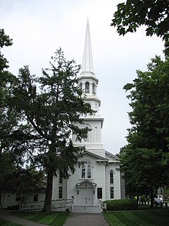
Marshfield Hills is a census-designated place (CDP) in the town of Marshfield in Plymouth County, Massachusetts, United States. The population was 2,356 at the 2010 census. The historic center of the village has been designated a historic district and listed on the National Register of Historic Places.

Pennville, Pennsylvania CDP in Pennsylvania, United States

Pennville is a census-designated place (CDP) in York County, Pennsylvania, United States. The population was 1,947 at the 2010 census.

Colonial Pine Hills, South Dakota CDP in South Dakota, United States

Colonial Pine Hills is a census-designated place (CDP) and unincorporated community in Pennington County, South Dakota, United States. The population was 1,903 at the 2020 census.

Chattaroy, West Virginia Census-designated place in West Virginia, United States

Chattaroy is a census-designated place (CDP) in Mingo County, West Virginia, United States. The population was 756 at the 2010 census.

Orleans (CDP), Massachusetts Census-designated place in Massachusetts, United States

Orleans is a census-designated place (CDP) in the town of Orleans in Barnstable County, Massachusetts, United States. The population was 1,621 at the 2010 census.

Provincetown (CDP), Massachusetts Census-designated place in Massachusetts, United States

Provincetown (CDP) is a census-designated place (CDP) in the town of Provincetown in Barnstable County, Massachusetts, United States. The population was 2,642 at the 2010 census, out of 2,942 in the entire town.

Andover (CDP), Massachusetts Census-designated place in Massachusetts, United States

Andover is a census-designated place (CDP) in the town of Andover in Essex County, Massachusetts, United States. The population was 8,762 at the 2010 census.

Rockport (CDP), Massachusetts Census-designated place in Massachusetts, United States

Rockport is a census-designated place (CDP) in the town of Rockport in Essex County, Massachusetts, United States. The population was 4,966 at the 2010 census.

Salisbury (CDP), Massachusetts Census-designated place in Massachusetts, United States

Salisbury is a census-designated place (CDP) in the town of Salisbury in Essex County, Massachusetts, United States. The population was 4,869 at the 2010 census.

North Brookfield (CDP), Massachusetts CDP in Massachusetts, United States

North Brookfield is a census-designated place (CDP) in the town of North Brookfield in Worcester County, Massachusetts, United States. The population was 2,265 at the 2010 census.

References

  1. "2020 U.S. Gazetteer Files". United States Census Bureau. Retrieved May 21, 2022.
  2. "Profile of General Population and Housing Characteristics: 2010 Demographic Profile Data (DP-1): Ipswich CDP, Massachusetts". United States Census Bureau . Retrieved September 6, 2012.
  3. "Geographic Identifiers: 2010 Demographic Profile Data (G001): Ipswich CDP, Massachusetts". United States Census Bureau . Retrieved September 6, 2012.
  4. "Census of Population and Housing". Census.gov. Retrieved June 4, 2016.