Brandon, Wisconsin

Last updated

Brandon, Wisconsin
Brandon Wisconsin Downtown Looking West WIS49.jpg
Looking west in Brandon
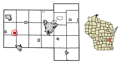
Fond du Lac County Wisconsin Incorporated and Unincorporated areas Brandon Highlighted.svg
Location of Brandon in Fond du Lac County, Wisconsin.
Coordinates: 43°44′8″N88°46′56″W / 43.73556°N 88.78222°W / 43.73556; -88.78222
Country Flag of the United States.svg  United States
State Flag of Wisconsin.svg  Wisconsin
County   Fond du Lac
settled1856
Area
[1]
  Total0.76 sq mi (1.98 km2)
  Land0.76 sq mi (1.96 km2)
  Water0.01 sq mi (0.02 km2)
Elevation
[2]
1,001 ft (305 m)
Population
 (2010) [3]
  Total879
  Estimate 
(2019) [4]
853
  Density1,128.31/sq mi (435.78/km2)
Time zone UTC-6 (Central (CST))
  Summer (DST) UTC-5 (CDT)
Area code 920
FIPS code 55-09300 [5]
GNIS feature ID1562145 [2]
Website villageofbrandon.com
Looking east at Brandon on Highway 49 BrandonWisconsinDowntownWIS49.jpg
Looking east at Brandon on Highway 49

Brandon is a village in Fond du Lac County, Wisconsin, United States. The population was 879 at the 2010 census.

Contents

History

Brandon was originally dubbed "Bungtown" in the town's creation in 1856. [6]

The Rens Hemp Company of Brandon, Wisconsin, closed in 1958, the last legal hemp producer nationwide in operation following the World Wars. [7] Prior to its 1957 shutdown, Rens had been the primary provider of hemp rope for the United States Navy. [8]

Geography

Brandon is located at 43°44′8″N88°46′56″W / 43.73556°N 88.78222°W / 43.73556; -88.78222 (43.735444, -88.782093). [9]

The source of the northernmost West Branch of the Rock River (Mississippi River tributary) is located in the Community Park on the west edge of Brandon.

According to the United States Census Bureau, the village has a total area of 0.77 square miles (1.99 km2), of which, 0.76 square miles (1.97 km2) of it is land and 0.01 square miles (0.03 km2) is water. [10]

Demographics

Historical population
CensusPop.Note
1880 601
1890 6609.8%
1900 6630.5%
1910 6843.2%
1920 682−0.3%
1930 646−5.3%
1940 7089.6%
1950 7282.8%
1960 7584.1%
1970 87215.0%
1980 862−1.1%
1990 8721.2%
2000 9124.6%
2010 879−3.6%
2019 (est.)853 [4] −3.0%
U.S. Decennial Census [11]

2010 census

As of the census [3] of 2010, there were 879 people, 336 households, and 233 families living in the village. The population density was 1,156.6 inhabitants per square mile (446.6/km2). There were 369 housing units at an average density of 485.5 per square mile (187.5/km2). The racial makeup of the village was 94.8% White, 0.5% African American, 0.3% Native American, 3.1% from other races, and 1.4% from two or more races. Hispanic or Latino of any race were 5.0% of the population.

There were 336 households, of which 36.6% had children under the age of 18 living with them, 56.8% were married couples living together, 9.5% had a female householder with no husband present, 3.0% had a male householder with no wife present, and 30.7% were non-families. 25.9% of all households were made up of individuals, and 11.9% had someone living alone who was 65 years of age or older. The average household size was 2.58 and the average family size was 3.13.

The median age in the village was 38.4 years. 28.2% of residents were under the age of 18; 7.2% were between the ages of 18 and 24; 26.4% were from 25 to 44; 25.2% were from 45 to 64; and 13% were 65 years of age or older. The gender makeup of the village was 49.5% male and 50.5% female.

2000 census

As of the census [5] of 2000, there were 912 people, 342 households, and 258 families living in the village. The population density was 1,165.9 people per square mile (451.4/km2). There were 357 housing units at an average density of 456.4 per square mile (176.7/km2). The racial makeup of the village was 99.78% White, 0.11% Native American, 0.11% from other races. Hispanic or Latino of any race were 0.77% of the population.

There were 342 households, out of which 40.4% had children under the age of 18 living with them, 66.4% were married couples living together, 7.3% had a female householder with no husband present, and 24.3% were non-families. 21.9% of all households were made up of individuals, and 11.1% had someone living alone who was 65 years of age or older. The average household size was 2.67 and the average family size was 3.14.

In the village, the population was spread out, with 29.7% under the age of 18, 6.7% from 18 to 24, 32.2% from 25 to 44, 18.2% from 45 to 64, and 13.2% who were 65 years of age or older. The median age was 34 years. For every 100 females, there were 86.5 males. For every 100 females age 18 and over, there were 87.4 males.

The median income for a household in the village was $43,542, and the median income for a family was $50,227. Males had a median income of $35,595 versus $22,176 for females. The per capita income for the village was $17,437. About 4.3% of families and 5.3% of the population were below the poverty line, including 4.9% of those under age 18 and 9.1% of those age 65 or over.

Notable people

Images

Related Research Articles

<span class="mw-page-title-main">Sherrill, Iowa</span> City in Iowa, United States

Sherrill is a city in Dubuque County, Iowa, United States. The population was 189 at the time of the 2020 census, up from 186 in 2000.

<span class="mw-page-title-main">Ortonville, Michigan</span> Village in Michigan, United States

Ortonville is a village in north Oakland County in the U.S. state of Michigan. The village is within Brandon Township, although some development near the village lies within adjacent Oakland County, Groveland township and Lapeer County, Hadley township. The population was 1,291 as of the 2021 Census estimate. Ortonville lies on the northern edge of Metro Detroit and is approximately 41 miles north of Downtown Detroit.

<span class="mw-page-title-main">Brandon, Minnesota</span> City in Minnesota, United States

Brandon is a city in Douglas County, Minnesota, United States. The population was 501 at the 2020 census.

<span class="mw-page-title-main">Lake Bronson, Minnesota</span> City in Minnesota, United States

Lake Bronson is a city in Kittson County, Minnesota, United States. The population was 178 at the 2020 census. Lake Bronson State Park is nearby.

Victory Township is a township in Lake of the Woods County, Minnesota, United States. The 2010 census population was seven.

<span class="mw-page-title-main">Elmwood, Nebraska</span> Village in Nebraska, United States

Elmwood is a village in southeast Cass County, Nebraska, United States. The population was 654 at the 2020 census.

<span class="mw-page-title-main">Ferryville, Wisconsin</span> Village in Wisconsin, United States

Ferryville is a village in Crawford County, Wisconsin, United States. The population was 176 at the 2010 census. It is located on Wisconsin Highway 35 along the Great River Road.

<span class="mw-page-title-main">Neosho, Wisconsin</span> Village in Wisconsin, United States

Neosho is a village in Dodge County, Wisconsin, United States. The population was 574 at the 2010 census.

<span class="mw-page-title-main">Fairwater, Wisconsin</span> Village in Wisconsin, United States

Fairwater is a village in Fond du Lac County, Wisconsin, United States. The population was 371 at the 2010 census. The town of Metomen surrounds the village.

<span class="mw-page-title-main">Metomen, Wisconsin</span> Town in Wisconsin, United States

Metomen is a town in Fond du Lac County, Wisconsin, United States. The population was 709 at the 2000 census. The villages of Fairwater and Brandon, the unincorporated community of Metomen, and the ghost town of Reeds Corners is also located in the town.

<span class="mw-page-title-main">Monticello, Green County, Wisconsin</span> Village in Wisconsin, United States

Monticello is a village in Green County, Wisconsin, United States. The population was 1,217 as of the 2010 census.

<span class="mw-page-title-main">Hollandale, Wisconsin</span> Village in Wisconsin, United States

Hollandale is a village in Iowa County, Wisconsin, United States. The population was 306 at the 2020 census. It is part of the Madison Metropolitan Statistical Area.

<span class="mw-page-title-main">Wagner, Wisconsin</span> Town in Wisconsin, United States

Wagner is a town in Marinette County, Wisconsin, United States. The population was 722 at the 2000 census. The unincorporated communities of Goll, McAllister, Packard, and Wagner are located in the town.

<span class="mw-page-title-main">Cudahy, Wisconsin</span> City in Wisconsin, United States

Cudahy is a city in Milwaukee County, Wisconsin, United States. The population was 18,204 at the 2020 census.

<span class="mw-page-title-main">Glendale, Monroe County, Wisconsin</span> Town in Wisconsin, United States

Glendale is a town in Monroe County, Wisconsin, United States. The population was 579 at the 2000 census. The unincorporated community of Glendale is located in the town.

<span class="mw-page-title-main">Cazenovia, Wisconsin</span> Village in Wisconsin, United States

Cazenovia is a village in Richland and Sauk Counties in the U.S. state of Wisconsin. The population was 318 at the 2010 census. Of this, 314 were in Richland County, and only 4 were in Sauk County.

<span class="mw-page-title-main">Stockbridge, Wisconsin</span> Village in Wisconsin, United States

Stockbridge is a village in Calumet County, Wisconsin, United States. The population was 686 at the 2020 census. The village lies within the Town of Stockbridge.

<span class="mw-page-title-main">Fennimore, Wisconsin</span> City in Wisconsin, United States

Fennimore is a city in Grant County, Wisconsin, United States. The population was 2,497 at the 2010 census. The city's area was separated from the Town of Fennimore, which remains as an adjacent rural area.

<span class="mw-page-title-main">Rochester, Wisconsin</span> Village in Wisconsin

Rochester is a village in Racine County, Wisconsin, United States. The population was 3,785 at the 2020 census. The village is located within the former Town of Rochester. On November 4, 2008, the village of Rochester voted to consolidate with the Town of Rochester.

<span class="mw-page-title-main">Darien, Wisconsin</span> Village in Wisconsin, United States

Darien is a village in Walworth County, Wisconsin, United States. The population was 1,573 at the 2020 census. The village is located within the Town of Darien.

References

  1. "2019 U.S. Gazetteer Files". United States Census Bureau. Retrieved August 7, 2020.
  2. 1 2 "US Board on Geographic Names". United States Geological Survey. October 25, 2007. Retrieved January 31, 2008.
  3. 1 2 "U.S. Census website". United States Census Bureau . Retrieved November 18, 2012.
  4. 1 2 "Population and Housing Unit Estimates". United States Census Bureau. May 24, 2020. Retrieved May 27, 2020.
  5. 1 2 "U.S. Census website". United States Census Bureau . Retrieved January 31, 2008.
  6. History of Brandon, Wisconsin
  7. TAPPI Journal. Technical Association of the Pulp and Paper Industry. 1999. p. 114.
  8. John Roulac (January 1, 1997). Hemp Horizons: The Comeback of the World's Most Promising Plant. Chelsea Green Pub. p. 59. ISBN   978-0-930031-93-0.
  9. "US Gazetteer files: 2010, 2000, and 1990". United States Census Bureau. February 12, 2011. Retrieved April 23, 2011.
  10. "US Gazetteer files 2010". United States Census Bureau. Archived from the original on January 25, 2012. Retrieved November 18, 2012.
  11. "Census of Population and Housing". Census.gov. Retrieved June 4, 2015.