Fond du Lac County, Wisconsin

Last updated

Fond du Lac County, Wisconsin
Fond du Lac Co Building.jpg
Fond du Lac County City/County Government Center.
Fond du Lac County Seal.png
Map of Wisconsin highlighting Fond du Lac County.svg
Map of Wisconsin showing Fond du Lac County
Map of USA WI.svg
Wisconsin's location in the contiguous United States
Coordinates: 43°46′N88°29′W / 43.76°N 88.49°W / 43.76; -88.49
Incorporated 1839 [1]
Named for French term meaning 'farthest end of the lake'. [2]
County seat Fond du Lac
Largest city Fond du Lac
Municipalities
33 (total)
  • 3 cities
  • 21 towns
  • 9 villages
Government
  Type County
  Body Board of Supervisors
  ExecutiveSam Kaufman
  County Board25 supervisors
Area
  Total1,980 km2 (766 sq mi)
  Land1,900 km2 (720 sq mi)
  Water120 km2 (46 sq mi)
  Rank 40th largest county in Wisconsin
Population
 (2020) [3]
  Total104,154
  Rank 16th largest county in Wisconsin
  Density55.9/km2 (144.7/sq mi)
Time zone UTC−6 (Central)
  Summer (DST) UTC−5 (Central)
ZIP Code
54971, 53931, 53919, 53946, 53963, 54964, 54932, 54974, 53065, 53006, 54979, 54937, 54935, 53048, 53010, 53040, 53011, 53019, 53057, 53079, 53049, 53061, 53014
Area codes 920
Congressional districts 6th
Interstates I-41.svg
U.S. Highways US 41.svg US 45.svg US 151.svg
State Routes WIS 23.svg WIS 26.svg WIS 44.svg WIS 49.svg WIS 67.svg WIS 175.svg
Airports Fond du Lac County Airport
Waterways Fond du Lac River
Milwaukee River
Rock River
Sheboygan River
Lake Winnebago
Websitewww.fdlco.wi.gov

Fond du Lac County is a county in the U.S. state of Wisconsin. As of the 2020 census, the population was 104,154. [4] Its county seat is Fond du Lac. [5] The county was created in the Wisconsin Territory in 1836 and later organized in 1844. [6] Fond du Lac is French for "bottom of the lake", given so because of the county's location at the southern shore of Lake Winnebago. [7] [8] [9] Fond du Lac County comprises the Fond du Lac, Wisconsin Metropolitan Statistical Area. [10] The Holyland region is in northeastern Fond du Lac County.

Contents

Geography

According to the U.S. Census Bureau, the county has a total area of 766 square miles (1,980 km2), of which 720 square miles (1,900 km2) is land and 46 square miles (120 km2) (6.0%) is water. [11]

Adjacent counties

National protected area

Transportation

Major highways

Railroads

Buses

Airport

Fond du Lac County Airport ( IATA : FLD, ICAO : KFLD, FAA LID : FLD) serves the county and surrounding communities.

Climate

Fond du Lac County
Climate chart (explanation)
J
F
M
A
M
J
J
A
S
O
N
D
 
 
73
 
 
−8
−12
 
 
68
 
 
−7
−13
 
 
85
 
 
4
−6
 
 
151
 
 
17
2
 
 
126
 
 
23
6
 
 
142
 
 
25
14
 
 
94
 
 
28
16
 
 
90
 
 
24
14
 
 
80
 
 
22
11
 
 
125
 
 
15
7
 
 
65
 
 
5
−2
 
 
70
 
 
−3
−10
Average max. and min. temperatures in °C
Precipitation totals in mm
Source: [12]
Imperial conversion
JFMAMJJASOND
 
 
2.9
 
 
18
10
 
 
2.7
 
 
19
9
 
 
3.3
 
 
39
21
 
 
5.9
 
 
63
36
 
 
5
 
 
73
43
 
 
5.6
 
 
77
57
 
 
3.7
 
 
82
61
 
 
3.5
 
 
75
57
 
 
3.1
 
 
72
52
 
 
4.9
 
 
59
45
 
 
2.6
 
 
41
28
 
 
2.8
 
 
27
14
Average max. and min. temperatures in °F
Precipitation totals in inches

Demographics

Historical population
CensusPop.Note
1840 139
1850 14,51010,338.8%
1860 34,154135.4%
1870 46,27335.5%
1880 46,8591.3%
1890 44,088−5.9%
1900 47,5897.9%
1910 51,6108.4%
1920 56,1198.7%
1930 59,8836.7%
1940 62,3534.1%
1950 67,8298.8%
1960 75,08510.7%
1970 84,56712.6%
1980 88,9645.2%
1990 90,0831.3%
2000 97,2968.0%
2010 101,6334.5%
2020 104,1542.5%
U.S. Decennial Census [13]
1790–1960 [14] 1900–1990 [15]
1990–2000 [16] 2010–2020 [4]

2020 census

As of the census of 2020, [3] the population was 104,154. The population density was 144.7 inhabitants per square mile (55.9/km2). There were 45,740 housing units at an average density of 63.6 units per square mile (24.6 units/km2). The racial makeup of the county was 88.0% White, 2.3% Black or African American, 1.2% Asian, 0.5% Native American, 3.0% from other races, and 5.0% from two or more races. Ethnically, the population was 6.4% Hispanic or Latino of any race.

2000 Census Age Pyramid for Fond du Lac County USA Fond du Lac County, Wisconsin age pyramid.svg
2000 Census Age Pyramid for Fond du Lac County

2000 census

As of the census [17] of 2000, there were 97,296 people, 36,931 households, and 25,482 families residing in the county. The population density was 135 people per square mile (52 people/km2). There were 39,271 housing units at an average density of 54 units per square mile (21 units/km2). The racial makeup of the county was 96.16% White, 0.90% Black or African American, 0.38% Native American, 0.87% Asian, 0.03% Pacific Islander, 0.84% from other races, and 0.82% from two or more races. 2.04% of the population were Hispanic or Latino of any race. 57.7% were of German, 6.1% Irish and 5.3% American ancestry. 95.5% spoke English, 2.1% Spanish and 1.3% German as their first language.

There were 36,931 households, out of which 32.80% had children under the age of 18 living with them, 57.70% were married couples living together, 7.80% had a female householder with no husband present, and 31.00% were non-families. 25.40% of all households were made up of individuals, and 10.80% had someone living alone who was 65 years of age or older. The average household size was 2.52 and the average family size was 3.04.

In the county, the population was spread out, with 25.20% under the age of 18, 9.40% from 18 to 24, 28.70% from 25 to 44, 22.40% from 45 to 64, and 14.30% who were 65 years of age or older. The median age was 37 years. For every 100 females there were 95.30 males. For every 100 females age 18 and over, there were 92.20 males.

In 2017, there were 1,066 births, giving a general fertility rate of 57.7 births per 1000 women aged 15–44, the 20th lowest rate out of all 72 Wisconsin counties. [18] Additionally, there were 74 reported induced abortions performed on women of Fond du Lac County residence in 2017. [19]

Communities

Fond du Lac Lighthouse in Lakeside Park Fond du Lac Wisconsin Lighthouse.jpg
Fond du Lac Lighthouse in Lakeside Park
Farming in western Fond du Lac County FondduLacCountyWisconsinFarm.jpg
Farming in western Fond du Lac County

Cities

Villages

Towns

Census-designated places

Unincorporated communities

Grandstands for the Fond du Lac County Fair FondDuLacWisconsinCountyFairgrounds.jpg
Grandstands for the Fond du Lac County Fair

Ghost towns/neighborhoods

Public High Schools

Politics

Fond du Lac has been a historically Republican county, as the party was founded in the town of Ripon, located within the county. It has only voted Democratic in the national landslides of 1964, 1936, and 1932, as well as from 1872 to 1892.

United States presidential election results for Fond du Lac County, Wisconsin [20]
Year Republican Democratic Third party
No.%No.%No.%
2020 35,75462.45%20,58835.96%9091.59%
2016 31,02259.89%17,38733.57%3,3876.54%
2012 30,35556.84%22,37941.91%6681.25%
2008 28,16453.83%23,46344.84%6961.33%
2004 33,29162.77%19,21636.23%5291.00%
2000 26,54856.98%18,18139.02%1,8603.99%
1996 16,48844.65%15,54242.08%4,90113.27%
1992 19,78544.45%13,75730.91%10,96424.63%
1988 21,98557.59%15,88741.62%3030.79%
1984 26,06964.61%13,98334.66%2940.73%
1980 24,19656.97%15,29336.01%2,9817.02%
1976 22,22655.79%16,57141.59%1,0442.62%
1972 21,00760.99%12,05034.99%1,3864.02%
1968 18,18455.59%12,56338.41%1,9626.00%
1964 12,70841.29%18,04058.61%300.10%
1960 19,49859.65%13,13240.17%580.18%
1956 21,49672.46%7,94026.76%2300.78%
1952 22,79474.43%7,72425.22%1070.35%
1948 13,76059.61%8,90438.57%4191.82%
1944 16,78563.81%9,37835.65%1430.54%
1940 16,80461.46%10,32337.76%2150.79%
1936 9,17935.40%14,82157.16%1,9317.45%
1932 8,43633.74%16,14364.56%4251.70%
1928 12,59351.36%11,71947.80%2050.84%
1924 8,51641.62%2,22210.86%9,72247.52%
1920 12,54374.58%3,40920.27%8675.15%
1916 5,78152.16%5,02145.30%2822.54%
1912 3,01431.34%4,83850.31%1,76418.34%
1908 5,87250.86%5,19444.99%4794.15%
1904 7,02759.58%4,41737.45%3502.97%
1900 6,25853.82%5,14044.20%2301.98%
1896 6,17454.15%4,93343.27%2942.58%
1892 4,12942.47%5,25454.04%3393.49%

See also

Related Research Articles

<span class="mw-page-title-main">Winnebago County, Wisconsin</span> County in Wisconsin, United States

Winnebago County is a county in the U.S. state of Wisconsin. As of the 2020 census, the population was 171,730. Its county seat is Oshkosh. It was named for the historic Winnebago people, a federally recognized Native American tribe now known as the Ho-Chunk Nation. Chief Oshkosh was a Menominee leader in the area. Winnebago County comprises the Oshkosh-Neenah, WI Metropolitan Statistical Area, which is included in the Appleton-Oshkosh-Neenah, WI Combined Statistical Area.

<span class="mw-page-title-main">Sheboygan County, Wisconsin</span> County in Wisconsin, United States

Sheboygan County is a county in the U.S. state of Wisconsin. It is named after the Sheboygan River. As of the 2020 census, the population was 118,034. Its county seat is Sheboygan. The county was created in 1836 and organized in 1846. At the time, it was located in the Wisconsin Territory. Sheboygan County comprises the Sheboygan, WI Metropolitan Statistical Area. Part of the Holyland region is located in northwestern Sheboygan County.

<span class="mw-page-title-main">Sawyer County, Wisconsin</span> County in Wisconsin, United States

Sawyer County is a county in the U.S. state of Wisconsin. As of the 2020 census, its population was 18,074. Its county seat is Hayward. The county partly overlaps with the reservation of the Lac Courte Oreilles Band of Lake Superior Chippewa Indians.

<span class="mw-page-title-main">Outagamie County, Wisconsin</span> County in Wisconsin

Outagamie County is a county in the Fox Cities region of the U.S. state of Wisconsin, located in the northeast of the state. As of the 2020 Census, the population was 190,705. Its county seat is Appleton.

<span class="mw-page-title-main">Green Lake County, Wisconsin</span> County in Wisconsin, United States

Green Lake County is a county located in the U.S. state of Wisconsin. As of the 2020 census, the population was 19,018. Its county seat is Green Lake. In 2020, the center of population of Wisconsin was located in Green Lake County, near the city of Markesan.

<span class="mw-page-title-main">Dodge County, Wisconsin</span> County in Wisconsin, United States

Dodge County is a county located in the U.S. state of Wisconsin. As of the 2020 census, the population was 89,396. Its county seat is Juneau. The county was created from the Wisconsin Territory in 1836 and organized in 1844.

<span class="mw-page-title-main">Calumet County, Wisconsin</span> County in Wisconsin, United States

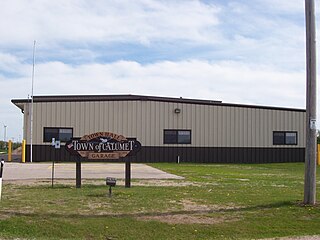
Calumet County is a county located in the U.S. state of Wisconsin. As of the 2020 census, the population was 52,442. The county seat is Chilton. The county was created in 1836 and organized in 1850.

<span class="mw-page-title-main">Brothertown, Wisconsin</span> Town in Wisconsin, United States

Brothertown is a town in Calumet County in the U.S. state of Wisconsin. The population was 1,329 at the 2010 census. The unincorporated communities of Brothertown, Charlesburg, Eckers Lakeland, Jericho, and Maple Heights are located in the town. The unincorporated community of Calumetville is also located partially in the town.

<span class="mw-page-title-main">Calumet, Wisconsin</span> Town in Wisconsin, United States

Calumet is a town in Fond du Lac County, Wisconsin, United States. The population was 1,514 at the 2000 census. The unincorporated communities of Artesia Beach, Calumet Harbor, Garnet, Highland Park, Johnsburg, Laudolff Beach, Marytown, Pipe, Pukwana Beach, Winnebago Heights, and Winnebago Park are located within the town. The unincorporated community of Calumetville is located partially in the town.

<span class="mw-page-title-main">Campbellsport, Wisconsin</span> Village in Wisconsin, United States

Campbellsport is a village in Fond du Lac County, Wisconsin, United States. The population was 2,016 at the 2010 census.

<span class="mw-page-title-main">Metomen, Wisconsin</span> Town in Wisconsin, United States

Metomen is a town in Fond du Lac County, Wisconsin, United States. The population was 709 at the 2000 census. The villages of Fairwater and Brandon, the unincorporated community of Metomen, and the ghost town of Reeds Corners is also located in the town.

<span class="mw-page-title-main">Taycheedah, Wisconsin</span> Town in Wisconsin, United States

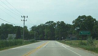
Taycheedah is a town in Fond du Lac County, Wisconsin, United States. The population was 3,666 at the 2000 census. The census-designated places of St. Peter and Taycheedah and the unincorporated communities of Hopokoekau Beach, Linden Beach, Minawa Beach, Peebles, Silica, and Welling Beach are located in the town, as well as Malone, which is partially located in the town.

<span class="mw-page-title-main">Fond du Lac, Wisconsin</span> City in Wisconsin, United States

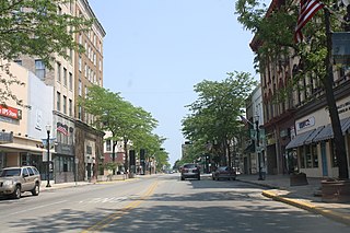
Fond du Lac is a city in and the county seat of Fond du Lac County, Wisconsin, United States. The population was 44,678 at the 2020 census. The city forms the core of the Fond du Lac metropolitan statistical area, which includes all of Fond du Lac County. Fond du Lac is the 348th-largest metropolitan area in the United States.

<span class="mw-page-title-main">Ripon, Wisconsin</span> City in Wisconsin, United States

Ripon is a city in Fond du Lac County, Wisconsin, United States. The population was 7,863 at the 2020 census. The city is surrounded by the Town of Ripon.

<span class="mw-page-title-main">Rosendale, Wisconsin</span> Village in Wisconsin, United States

Rosendale is a village in Fond du Lac County, Wisconsin, United States. The population was 1,063 at the 2010 census. The village is located partially within the Town of Rosendale and partially within the Town of Springvale.

Wisconsin's 6th congressional district is a congressional district of the United States House of Representatives in eastern Wisconsin. It is based in the rural, suburban and exurban communities between Madison, Milwaukee, and Green Bay. It also includes the village of River Hills in far northern Milwaukee County. The district is currently represented by Glenn Grothman (R-Glenbeaulah) who took office in January 2015.

<span class="mw-page-title-main">Taycheedah (CDP), Wisconsin</span> Census-designated place in Wisconsin, United States

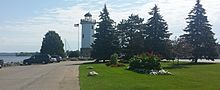
Taycheedah, Wisconsin is an unincorporated census-designated place in the Town of Taycheedah in Fond du Lac County, Wisconsin. The community is located adjacent to the city of Fond du Lac and Lake Winnebago. As of the 2010 census, its population is 704. Taycheedah calls itself the "Sheepshead Fishing Center of the World". U.S. Route 151 ran through the community until a bypass around Fond du Lac was built in the 2000s.

<span class="mw-page-title-main">St. Peter, Wisconsin</span> Census-designated place in Wisconsin, United States

St. Peter, Wisconsin is an unincorporated census-designated place in the Town of Taycheedah in Fond du Lac County, Wisconsin. It is located approximately 2 miles (3.2 km) northeast of Peebles and 1 mile (1.6 km) south of Silica. It was located on Wisconsin Highway 149 before the highway was decommissioned and turned over to county control as County Highway WH. As of the 2010 census, its population is 1,489.

Mascoutin Valley State Trail is a rail trail in northeastern Wisconsin. The trail is used for walking, bicycling, horseback riding, and snowmobiling during the winter months. The trail can also be used for cross-country skiing and snowshoeing but the trail is not groomed and must be shared with snowmobiles. Numerous miles of snowmobile trails connect to the Mascoutin Valley State Trail.

Ignatius Klotz, Sr. was an American farmer and politician

References

  1. "County Facts - Fond du Lac County". www.fdlco.wi.gov. Retrieved May 7, 2018.
  2. "County History". Fond du lac County. Retrieved June 7, 2021.
  3. 1 2 "2020 Decennial Census: Fond du Lac County, Wisconsin". data.census.gov. U.S. Census Bureau. Retrieved July 5, 2022.
  4. 1 2 "State & County QuickFacts". United States Census Bureau. Archived from the original on June 6, 2011. Retrieved January 18, 2014.
  5. "Find a County". National Association of Counties. Archived from the original on May 31, 2011. Retrieved June 7, 2011.
  6. "Wisconsin: Individual County Chronologies". Wisconsin Atlas of Historical County Boundaries. The Newberry Library. 2007. Archived from the original on April 14, 2017. Retrieved August 13, 2015.
  7. "Dictionary of Wisconsin History". Wisconsin Historical Society. Archived from the original on June 11, 2011. Retrieved October 20, 2008.
  8. Clorissa Swingen (Spring 1988). "Fond du Lac: Links to our Past". Archived from the original on June 7, 2010. Retrieved March 20, 2007.
  9. Gannett, Henry (1905). The Origin of Certain Place Names in the United States. Govt. Print. Off. pp.  128.
  10. "Metropolitan Statistical Areas of Wisconsin's 2014 Winter Report on Wisconsin Department of Revenue Division of Research & Policy" (PDF). Archived (PDF) from the original on October 9, 2022.
  11. "2010 Census Gazetteer Files". United States Census Bureau. August 22, 2012. Retrieved August 4, 2015.
  12. "NASA Earth Observations Data Set Index". NASA. Archived from the original on May 10, 2020. Retrieved January 30, 2016.
  13. "U.S. Decennial Census". United States Census Bureau. Retrieved August 4, 2015.
  14. "Historical Census Browser". University of Virginia Library. Retrieved August 4, 2015.
  15. Forstall, Richard L., ed. (March 27, 1995). "Population of Counties by Decennial Census: 1900 to 1990". United States Census Bureau. Retrieved August 4, 2015.
  16. "Census 2000 PHC-T-4. Ranking Tables for Counties: 1990 and 2000" (PDF). United States Census Bureau. April 2, 2001. Archived (PDF) from the original on October 9, 2022. Retrieved August 4, 2015.
  17. "U.S. Census website". United States Census Bureau . Retrieved May 14, 2011.
  18. "Annual Wisconsin Birth and Infant Mortality Report, 2017 P-01161-19 (June 2019): Detailed Tables". Archived from the original on June 19, 2019. Retrieved June 19, 2019.
  19. Reported Induced Abortions in Wisconsin, Office of Health Informatics, Division of Public Health, Wisconsin Department of Health Services. Section: Trend Information, 2013-2017, Table 18, pages 17-18
  20. Leip, David. "Dave Leip's Atlas of U.S. Presidential Elections". uselectionatlas.org. Retrieved November 11, 2020.

Further reading