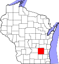
According to the U.S. Census Bureau, the county has a total area of 907 square miles (2,350km2), of which 876 square miles (2,270km2) is land and 31 square miles (80km2) (3.5%) is water.[5]
U.S. Decennial Census[8] 1790–1960[9] 1900–1990[10] 1990–2000[11] 2010–2020[2]
2020 census
As of the 2020 census, the county had a population of 89,396 and a population density of 102.1 peopleper square mile (39.4 people/km2).[1]
The median age was 43.3 years. 19.9% of residents were under the age of 18 and 19.0% of residents were 65 years of age or older. For every 100 females there were 112.2 males, and for every 100 females age 18 and over there were 113.4 males age 18 and over.[12]
45.1% of residents lived in urban areas, while 54.9% lived in rural areas.[14]
There were 35,437 households in the county, of which 26.4% had children under the age of 18 living in them. Of all households, 50.3% were married-couple households, 19.6% were households with a male householder and no spouse or partner present, and 21.8% were households with a female householder and no spouse or partner present. About 28.7% of all households were made up of individuals and 12.6% had someone living alone who was 65 years of age or older.[12]
There were 38,123 housing units at an average density of 43.5 unitsper square mile (16.8 units/km2), of which 7.0% were vacant. Among occupied housing units, 71.0% were owner-occupied and 29.0% were renter-occupied. The homeowner vacancy rate was 1.1% and the rental vacancy rate was 5.6%.[1][12]
2000 Census Age Pyramid for Dodge County
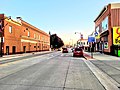
Dodge County FairgroundsEntering Dodge County on US 151
2000 census
As of the census of 2000,[15] there were 85,897 people, 31,417 households, and 22,313 families residing in the county. The population density was 97 peopleper square mile (37 people/km2). There were 33,672 housing units at an average density of 38 unitsper square mile (15 units/km2). The racial makeup of the county was 95.28% White, 2.49% Black or African American, 0.40% Native American, 0.34% Asian, 0.03% Pacific Islander, 0.87% from other races, and 0.58% from two or more races. 2.55% of the population were Hispanic or Latino of any race. Ancestry-wise, 56.2% were of German, 8.7% Irish, 5.0% English, 4.2% Norwegian and 3.9% selected "United States or American" ancestry. 95.4% spoke English, 2.2% Spanish and 2.0% other Indo-European languages as their language spoken at home.[16]
There were 31,417 households, out of which 33.90% had children under the age of 18 living with them, 59.60% were married couples living together, 7.50% had a female householder with no husband present, and 29.00% were non-families. 24.10% of all households were made up of individuals, and 10.80% had someone living alone who was 65 years of age or older. The average household size was 2.56 and the average family size was 3.05.[16]
In the county, the population was spread out, with 24.80% under the age of 18, 8.30% from 18 to 24, 31.20% from 25 to 44, 21.90% from 45 to 64, and 14.00% who were 65 years of age or older. The median age was 37 years. For every 100 females there were 109.70 males. For every 100 females age 18 and over, there were 110.80 males.
In 2017, there were 758 births, giving a general fertility rate of 54.0 births per 1000 women aged 15–44, the 12th lowest rate out of all 72 Wisconsin counties.[17]
Since 1940, Dodge County has been a Republican stronghold in presidential elections. It has voted Republican in every election in that span with the exception of the 1964 landslide victory of Democrat Lyndon B. Johnson. Only six other times in that span has the Democratic candidate obtained at least 40% of the vote. In 2024, Donald Trump received over 65% of the vote in Dodge County, the best Republican performance since the 1956 landslide reelection of Dwight D. Eisenhower.
Historically, Dodge County had been a major stronghold of the Democratic Party in Wisconsin, from the establishment of the state, in 1848, until the 1910s, when a combination of World War I and the rise of the progressive faction of Republicans began to eat into the Democratic vote in the county. A significant factor in the switch was the anti-war attitude among the county's large German American population. Democratic president Woodrow Wilson and Wisconsin's Democratic U.S. senator Paul O. Husting (who was actually from Dodge County) supported the declaration of war against Germany in 1917, while progressive Republican leader Robert M. La Follette was one of only six senators who voted against the resolution. In the next presidential election, Dodge County gave 77% of its votes to the Republican nominee—the largest majority the county has given to either party in the last 130 years.
This page is based on this Wikipedia article Text is available under the CC BY-SA 4.0 license; additional terms may apply. Images, videos and audio are available under their respective licenses.