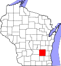
Ashippun, Wisconsin

Last updated

Town of Ashippun, Wisconsin
Flag of Ashippun, Wisconsin.png
WIMap-doton-Ashippun.png
Location of the Town of Ashippun, Wisconsin
Coordinates: 43°14′43″N88°29′17″W / 43.24528°N 88.48806°W / 43.24528; -88.48806
Country Flag of the United States.svg  United States
State Flag of Wisconsin.svg  Wisconsin
County Dodge
Government
  ChairmanSteve Panozzo
  SupervisorsWilliam Bremmer
James Meyer
Ryan Jacobs
Norman Greeb
Area
  Total35.7 sq mi (92.5 km2)
  Land35.6 sq mi (92.3 km2)
  Water0.1 sq mi (0.2 km2)
Elevation
[1]
909 ft (277 m)
Population
 (2000)
  Total2,308
  Density64.8/sq mi (25.0/km2)
Time zone UTC-6 (Central (CST))
  Summer (DST) UTC-5 (CDT)
FIPS code 55-03200 [2]
GNIS feature ID1582722 [1]

Ashippun is a town [3] in Dodge County, Wisconsin, United States. The unincorporated communities of Alderley, Ashippun, and Old Ashippun are located in the town. The population was 2,308 at the 2000 census.

Contents

Name origin

The name Ashippun is of Ojibwe origin. It is derived from ajiopan "decayed lungs". [4] Another theory derives the name from the Indian word for "raccoon", which is what the Indians called the river flowing through the eastern part of the town. [5] The Menominee name of the village, Ǣhsepan, reflects that meaning. [6] The Ojibway name meaning raccoon, is Esiban.

Geography

According to the United States Census Bureau, the town has a total area of 35.7 square miles (92.5 km2), of which, 35.6 square miles (92.3 km2) is land and 0.1 square miles (0.2 km2) of it (0.25%) is water.

Demographics

As of the census [2] of 2000, there were 2,308 people, 845 households, and 670 families residing in the town. The population density was 64.8 people per square mile (25.0/km2). There were 880 housing units at an average density of 24.7 per square mile (9.5/km2). The racial makeup of the town was 97.75% White, 0.13% Native American, 0.56% Asian, 0.13% Pacific Islander, 0.43% from other races, and 1.00% from two or more races. Hispanic or Latino people of any race were 1.13% of the population.

There were 845 households, out of which 36.1% had children under the age of 18 living with them, 71.6% were married couples living together, 4.5% had a female householder with no husband present, and 20.6% were non-families. 15.1% of all households were made up of individuals, and 5.4% had someone living alone who was 65 years of age or older. The average household size was 2.73 and the average family size was 3.05.

In the town, the population was spread out, with 25.6% under the age of 18, 6.5% from 18 to 24, 32.1% from 25 to 44, 25.6% from 45 to 64, and 10.2% who were 65 years of age or older. The median age was 37 years. For every 100 females, there were 107.4 males. For every 100 females age 18 and over, there were 110.6 males.

The median income for a household in the town was $55,982, and the median income for a family was $60,347. Males had a median income of $37,363 versus $24,559 for females. The per capita income for the town was $22,698. About 1.6% of families and 2.1% of the population were below the poverty line, including 1.2% of those under age 18 and 3.2% of those age 65 or over.

Education

Ashippun is within the Oconomowoc Area School District. [7] The public high school is Oconomowoc High School.

Tourist attractions

Ashippun is the home of Honey of a Museum, or Honey Acres, a museum of beekeeping established in 1852. [8]

Notable people

Related Research Articles

<span class="mw-page-title-main">Calamus, Wisconsin</span> Town in Wisconsin, United States

Calamus is a town in Dodge County, Wisconsin, United States. The population was 1,005 at the 2000 census. The unincorporated community of South Beaver Dam is located in the town. The unincorporated community of Lost Lake is also located partially in the town.

<span class="mw-page-title-main">Hubbard, Dodge County, Wisconsin</span> Town in Wisconsin, United States

Hubbard is a town in Dodge County, Wisconsin, United States. The population was 1,643 at the 2000 census. The unincorporated community of Neda is located in the town. The town is named for Henry Hubbard, the governor of New Hampshire from 1842 to 1844.

<span class="mw-page-title-main">Tainter, Wisconsin</span> Town in Wisconsin, United States

The Town of Tainter is a town in Dunn County, Wisconsin, United States. The population was 2,116 at the 2000 census. Part of the census-designated place of Tainter Lake is located in the town. The unincorporated community of Norton is also located in the town.

<span class="mw-page-title-main">Norwood, Wisconsin</span> Town in Wisconsin, United States

Norwood is a town in Langlade County, Wisconsin, United States. The population was 913 at the 2010 census. The unincorporated community of Phlox is located in the town.

<span class="mw-page-title-main">Meeme, Wisconsin</span> Town in Wisconsin, United States

Meeme is a town in Manitowoc County, Wisconsin, United States. The population was 1,538 at the 2000 census. Its Menominee name is Omīnīw which means "pigeon". The Menominee sold this land to the United States in the 1831 Treaty of Washington.

<span class="mw-page-title-main">Porterfield, Wisconsin</span> Town in Wisconsin, United States

Porterfield is a town in Marinette County, Wisconsin, United States. The population was 1,991 at the 2000 census. The unincorporated communities of Bagley Junction, Miles, Porterfield, Rubys Corner, and Walsh are located in the town.

<span class="mw-page-title-main">Packwaukee, Wisconsin</span> Town in Wisconsin, United States

Packwaukee is a town in Marquette County, Wisconsin, United States. The population was 2,574 at the 2000 census. The unincorporated communities of Buffalo Shore Estates and Packwaukee are located in the town.

<span class="mw-page-title-main">Stiles, Wisconsin</span> Town in Wisconsin, United States

Stiles is a town in Oconto County, Wisconsin, United States. The population was 1,465 at the 2000 census. The unincorporated communities of Stiles and Stiles Junction are located in the town. Situated within ancestral Menominee territory that was ceded to the United States in the 1836 Treaty of the Cedars, its Menominee name is Pæhkuahkiw which means "pointed hillock".

<span class="mw-page-title-main">Underhill, Wisconsin</span> Town in Wisconsin, United States

Underhill is a town in Oconto County, Wisconsin, United States. The population was 846 at the 2000 census.

<span class="mw-page-title-main">Honey Creek, Sauk County, Wisconsin</span> Town in Wisconsin, United States

Honey Creek is a town in Sauk County, Wisconsin, United States. The town took its name from the nearby stream of the same name. The population was 749 at the 2020 census. The unincorporated communities of Denzer and Leland are located in the town.

<span class="mw-page-title-main">Waukechon, Wisconsin</span> Town in Wisconsin, United States

Waukechon is a town in Shawano County, Wisconsin, United States. The population was 928 at the 2000 census. The unincorporated community of Lunds is located in the town. Its Menominee name is Wākecānāpāēw, meaning "crooked beak man", a reference to the Thunderbird Clan of the Ho-Chunk.

<span class="mw-page-title-main">Lac La Belle, Wisconsin</span> Village in Wisconsin, United States

Lac La Belle is a village located mostly in Waukesha County in the U.S. state of Wisconsin. The population was 281 at the 2020 census. The village is located mostly within the town of Oconomowoc in Waukesha County. On March 28, 2002, the village annexed a portion of land in the town of Ixonia in Jefferson County.

<span class="mw-page-title-main">Oconomowoc Lake, Wisconsin</span> Village in Wisconsin, United States

Oconomowoc Lake is a village in Waukesha County, Wisconsin, United States. Located just outside the City of Oconomowoc, the village includes the residential area encircling Oconomowoc Lake.

<span class="mw-page-title-main">Okauchee Lake, Wisconsin</span> CDP in Wisconsin, United States

Okauchee Lake is a census-designated place (CDP) in Waukesha County, Wisconsin, United States. The population was 5,094 at the 2020 census. Okauchee Lake is located in the town of Oconomowoc.

<span class="mw-page-title-main">Summit, Waukesha County, Wisconsin</span> Village in Wisconsin, United States

Summit is a village in Waukesha County, Wisconsin, United States. The population was 4,784 at the 2020 census. The former unincorporated communities of Summit Center, Summit Corners, and Waterville are located in the village.

<span class="mw-page-title-main">Chain O' Lakes-King, Wisconsin</span> Former CDP in Wisconsin, United States

Chain O' Lakes-King is a former census-designated place (CDP) in Waupaca County, Wisconsin, United States. The population was 2,215 at the 2000 census. It is located within the towns of Farmington and Dayton. For the 2010 census, Chain O' Lakes-King was split into the CDPs of Chain O' Lakes and King.

<span class="mw-page-title-main">Poy Sippi, Wisconsin</span> Town in Wisconsin, United States

Poy Sippi is a town in Waushara County, Wisconsin, United States. The population was 972 at the 2000 census. The census-designated place of Poy Sippi is located in the town. The unincorporated communities of Borth and Fountain Valley are also located in the town.

<span class="mw-page-title-main">Middle Village, Wisconsin</span> CDP in Wisconsin, United States

Middle Village is a census-designated place (CDP), in the towns of Menominee and Red Springs, in Menominee and Shawano counties in the U.S. state of Wisconsin. It does not have any legal status as an incorporated municipality. The population was 290 at the 2020 census.

<span class="mw-page-title-main">Ixonia, Wisconsin</span> Town in Wisconsin, United States

Ixonia is a town in Jefferson County, Wisconsin. The population was 4,385 at the time of the 2010 census. The unincorporated communities of Ixonia and Pipersville are located within the town.

<span class="mw-page-title-main">Oconomowoc (town), Wisconsin</span> Town in Wisconsin, United States

Oconomowoc is a town in Waukesha County, Wisconsin, United States. The population was 8,836 at the 2020 census. The City of Oconomowoc and the Villages of Chenequa and Lac La Belle are located partially in the town. The unincorporated communities of Mapleton, Monterey, and Okauchee Lake, are located in the town. The unincorporated community of Stone Bank is located partially in the town.

References

  1. 1 2 U.S. Geological Survey Geographic Names Information System: Ashippun, Wisconsin
  2. 1 2 "U.S. Census website". United States Census Bureau . Retrieved January 31, 2008.
  3. "Towns" in Wisconsin perform most of the same functions as townships in many other states. see 'Wisconsin Blue Book 2022,' Town, pp 354-355
  4. Verwyst, Chrysostom. 1892. "Geographical Names in Wisconsin, Minnesota, and Michigan, Having a Chippewa Origin". Collections of the State Historical Society of Wisconsin 12: 390–398.
  5. 'Indian Names on Wisconsin's Map,' Virgil C. Vogel, University of Wisconsin Press: 1991, Names from Fauna, pg. 148
  6. Hoffman, Mike. "Menominee Place Names in Wisconsin". The Menominee Clans Story. Retrieved October 5, 2018.
  7. "2020 CENSUS - SCHOOL DISTRICT REFERENCE MAP: Dodge County, WI" (PDF). U.S. Census Bureau . Retrieved August 29, 2021.
  8. "Honey Acres - 'Honey of a Museum'". Travel Wisconsin . Retrieved February 23, 2023.
  9. Racine News Archived April 2, 2015, at the Wayback Machine