Hustisford (town), Wisconsin

Last updated

Hustisford, Wisconsin
Hustisford.jpg
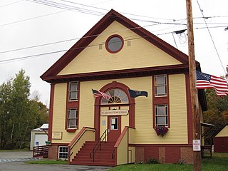
Hustisford town hall
WIMap-doton-Hustisford.png
Location of Hustisford town, Wisconsin
Coordinates: 43°19′06″N88°35′45″W / 43.31833°N 88.59583°W / 43.31833; -88.59583
Country Flag of the United States.svg  United States
State Flag of Wisconsin.svg  Wisconsin
County Dodge
Area
  Total34.9 sq mi (90.5 km2)
  Land33.7 sq mi (87.4 km2)
  Water1.2 sq mi (3.1 km2)
Elevation
846 ft (258 m)
Population
 (2000)
  Total1,379
  Density39.5/sq mi (15.2/km2)
Time zone UTC-6 (Central (CST))
  Summer (DST) UTC-5 (CDT)

Hustisford is a town in Dodge County, Wisconsin, United States. The population was 1,379 at the 2000 census. Most of the town residents live in the village of Hustisford, within the town.

Contents

History

It was named for John Hustis, a pioneer settler. [1]

Geography

According to the United States Census Bureau, the town has a total area of 34.9 square miles (90.5 km2), of which, 33.7 square miles (87.4 km2) of it is land and 1.2 square miles (3.1 km2) of it (3.44%) is water.

Demographics

As of the census [2] of 2000, there were 1,379 people, 492 households, and 411 families residing in the town. The population density was 40.9 people per square mile (15.8/km2). There were 546 housing units at an average density of 16.2 per square mile (6.2/km2). The racial makeup of the town was 99.49% White, 0.15% Native American, 0.07% Asian, 0.22% from other races, and 0.07% from two or more races. 0.94% of the population were Hispanic or Latino of any race.

There were 492 households, out of which 34.3% had children under the age of 18 living with them, 73.4% were married couples living together, 6.9% had a female householder with no husband present, and 16.3% were non-families. 12.4% of all households were made up of individuals, and 5.1% had someone living alone who was 65 years of age or older. The average household size was 2.80 and the average family size was 3.06.

In the town, the population was spread out, with 25.7% under the age of 18, 7.4% from 18 to 24, 27.6% from 25 to 44, 27.5% from 45 to 64, and 11.9% who were 65 years of age or older. The median age was 40 years. For every 100 females, there were 101.3 males. For every 100 females age 18 and over, there were 103.4 males.

The median income for a household in the town was $60,086, and the median income for a family was $62,112. Males had a median income of $38,224 versus $26,029 for females. The per capita income for the town was $23,965. About 4.6% of families and 5.5% of the population were below the poverty line, including 7.0% of those under age 18 and 9.9% of those age 65 or over.

Related Research Articles

<span class="mw-page-title-main">Sherrard, Illinois</span> Village in Illinois, United States

Sherrard is a village in Mercer County, Illinois, United States. The population was 692 at the 2020 census.

<span class="mw-page-title-main">McIntire, Iowa</span> City in Iowa, United States

McIntire is a city in Mitchell County, Iowa, United States. The population was 113 at the time of the 2020 census.

Greenwood is a town in Oxford County, Maine, United States. The population was 774 at the 2020 census. The town was named for surveyor Alexander Greenwood. The village of Locke Mills, on State Route 26 in the northern part of Greenwood, is the town's urban center and largest settlement.

Eaton Rapids Township is a civil township of Eaton County in the U.S. state of Michigan. The population was 3,991 at the 2020 United States Census.

Springwater is a town in Livingston County, New York, United States. The population was 2,439 at the 2010 census. Springwater is in the southeast part of the county.

<span class="mw-page-title-main">Oak Grove, Dodge County, Wisconsin</span> Town in Wisconsin, United States

Oak Grove is a town in Dodge County, Wisconsin, United States. The population was 1,126 at the 2000 census. The unincorporated community of Minnesota Junction is located in the town. The unincorporated community of Rolling Prairie is also located partially in the town.

<span class="mw-page-title-main">Farmington, Jefferson County, Wisconsin</span> Town in Wisconsin, United States

Farmington is a town in Jefferson County, Wisconsin, United States. The population as of the 2010 census was 1,380.

<span class="mw-page-title-main">Lake Koshkonong, Wisconsin</span> Census-designated place in Wisconsin, United States

Lake Koshkonong is a census-designated place (CDP) in the towns of Koshkonong and Sumner, Jefferson County, Wisconsin, United States. The population was 1,239 at the 2020 census. Lake Koshkonong is in the area.

<span class="mw-page-title-main">Okauchee Lake, Wisconsin</span> CDP in Wisconsin, United States

Okauchee Lake is a census-designated place (CDP) in Waukesha County, Wisconsin, United States. The population was 5,094 at the 2020 census. Okauchee Lake is located in the town of Oconomowoc.

<span class="mw-page-title-main">Dixon, Wyoming</span> Town in Wyoming, United States

Dixon is a town in Carbon County, Wyoming, United States. The population was 97 at the 2010 census.
<span class="mw-page-title-main">St. Albans, Maine</span> Town in the state of Maine, United States

St. Albans is a town in Somerset County, Maine, United States. The population was 2,045 at the 2020 census.

<span class="mw-page-title-main">Hustisford, Wisconsin</span> Village in Wisconsin, United States

Hustisford is a village in Dodge County, Wisconsin, United States. The population was 1,101 at the 2020 census. The village is located within the town of Hustisford.

<span class="mw-page-title-main">Lowell, Wisconsin</span> Village in Wisconsin, United States

Lowell is a village in Dodge County, Wisconsin, United States, along the Beaver Dam River. The population was 340 at the 2010 census. The village is located within the Town of Lowell.

Lowell is a town in Dodge County, Wisconsin, United States. The population was 1,169 at the 2000 census. The Village of Lowell and the unincorporated community of North Lowell are located in the town.

Eden is a town in Fond du Lac County, Wisconsin, United States. The population was 979 at the 2000 census. The Village of Eden is located within the town. The unincorporated community of Marblehead is located also in the town.

Rosendale is a town in Fond du Lac County, Wisconsin, United States. The population was 783 at the 2000 census. The village of Rosendale is located partially within the town. The unincorporated communities of Rosendale Center and West Rosendale are also located in the town.

The Town of Prairie du Sac is located in southwestern Sauk County, Wisconsin, United States. The population was 1,138 at the 2000 census. The Village of Prairie du Sac is located within the town. The unincorporated community of Loddes Mill is also located in the town.

<span class="mw-page-title-main">Wautoma (town), Wisconsin</span> Town in Wisconsin, United States

Wautoma is a town in Waushara County, Wisconsin, United States. The population was 1,312 at the 2000 census.

<span class="mw-page-title-main">East Millinocket, Maine</span> Town in the state of Maine, United States

East Millinocket is a town in Penobscot County, Maine, United States. The population was 1,572 at the 2020 census.

<span class="mw-page-title-main">Winterport, Maine</span> Town in the state of Maine, United States

Winterport is a town in Waldo County, Maine, United States. The population was 3,817 at the 2020 census. The Winterport Historic District, extending several blocks along Main Street, was listed on the National Register of Historic Places in 1975.

References

  1. Gannett, Henry (1905). The Origin of Certain Place Names in the United States. Govt. Print. Off. p. 164.
  2. "U.S. Census website". United States Census Bureau . Retrieved January 31, 2008.

43°19′06″N88°35′45″W / 43.31833°N 88.59583°W / 43.31833; -88.59583