Mount Olive, also spelled Mt. Olive is an unincorporated community and a census-designated place (CDP) in Jefferson County, Alabama. Its location is in the suburbs of Birmingham. As of the 2010 census, the population of the community is 4,079. Mount Olive is bordered on the south and the east by the town of Gardendale, and in fact, some areas that had previously been in Mount Olive have been annexed into Gardendale over the years. Running along part of the border between Mt. Olive and Gardendale is the major expressway, Interstate 65. Eventually, part of Birmingham's Northern Beltline will cut through northwestern sections of Mt. Olive. Mt. Olive has its own elementary school, and was formerly the home of a junior high school.

Shirley is a town in Brown Township, Hancock County and Greensboro Township, Henry County, Indiana, United States. The population was 830 at the 2010 census.

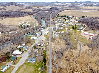
Burket is a town in Seward Township, Kosciusko County, in the U.S. state of Indiana. The population was 195 at the 2010 census.

Troy is a town in Waldo County, Maine, United States. The population was 1,018 at the 2020 census.

Goldsboro is a town in Caroline County, Maryland, United States. William James Yeager is the current mayor. The population was 246 at the 2010 United States Census. The zip code is 21636. First known as Oldtown, it was renamed in 1870 for the prominent Goldsborough family who owned land in the area. Castle Hall was listed on the National Register of Historic Places in 1975.

Bridgewater is a town in Grafton County, New Hampshire, United States. The population was 1,160 at the 2020 census.

Columbus is a town and the county seat of Polk County, North Carolina, United States. The population was 999 at the 2010 census.

Catawba is a village in Clark County, Ohio, United States. The population was 245 at the 2020 census. It is part of the Springfield, Ohio Metropolitan Statistical Area.

Bay View is a village in Erie County, Ohio, United States. The population was 608 at the 2020 census. It is part of the Sandusky, Ohio Metropolitan Statistical Area.
Willshire is a village in Van Wert County, Ohio, United States. The population was 405 at the 2020 census. It is included within the Van Wert, Ohio Micropolitan Statistical Area.

Luther is a town in Oklahoma County, Oklahoma, United States, and a part of the Oklahoma City Metropolitan Area. The population was 1,221 at the 2010 census. Sperling Best Places lists the population of 4073 for the 73054 Luther zip code, which includes the town and immediate surrounding area of rural residents.

Rothsville is an unincorporated community and census-designated place (CDP) in Warwick Township, Lancaster County, Pennsylvania, United States. The population was 3,044 at the 2010 census. Lititz is the town for residents' mailing addresses.
Plymouth is a town in Box Elder County, Utah, United States. The population was 414 at the 2010 census.

The Town of Pleasant Springs is located in Dane County, Wisconsin, United States. The population was 3,053 at the 2000 census. The unincorporated community of Kegonsa is located in the town. The unincorporated community of Hoffman Corners is also located partially in the town.
Dodge is a town in Trempealeau County, Wisconsin, United States. The population was 414 at the 2000 census. The census-designated place of Dodge is located in the town. The unincorporated community of Pine Creek is also located in the town.

Loveland Park is a census-designated place (CDP) located in Symmes Township, Hamilton County and Deerfield Township, Warren County, in the southwestern part of the U.S. state of Ohio. The CDP is named after the city of Loveland. The population was 1,737 at the 2020 census.

Williams Creek is a town in Washington Township, Marion County, Indiana, United States. It is located about 9 miles (14 km) north of downtown Indianapolis. The population was 430 at the 2020 census. It has existed as an "included town" since 1970, when it was incorporated into Indianapolis as part of Unigov. It is part of Indianapolis, but retains a functioning town government under IC 36-3-1-11.

Kittery is a census-designated place (CDP) consisting of the main village in the town of Kittery in York County, Maine, United States. The village is also known as Kittery Foreside. The population of the CDP was 4,562 at the 2010 census. It is part of the Portland–South Portland–Biddeford, Maine Metropolitan Statistical Area.

North Collins is a village in Erie County, New York, United States. The population was 1,255 at the 2021 census. The village is in the northwest corner of the town of North Collins.
Minong is a town in Washburn County, Wisconsin, United States. The population was 858 at the 2000 census. The Village of Minong is located within the town.