Fox Lake, Wisconsin

Last updated

Fox Lake
city
FoxLakeWisconsinDowntown1.jpg
Downtown Fox Lake
Dodge County Wisconsin Incorporated and Unincorporated areas Fox Lake Highlighted.svg
Location of Fox Lake in Dodge County, Wisconsin.
USA Wisconsin location map.svg
Red pog.svg
Fox Lake
Location within the state of Wisconsin
Coordinates: 43°33′46″N88°54′36″W / 43.56278°N 88.91000°W / 43.56278; -88.91000
Country Flag of the United States.svg  United States
State Flag of Wisconsin.svg  Wisconsin
County Dodge
Area
[1]
  Total1.62 sq mi (4.20 km2)
  Land1.57 sq mi (4.06 km2)
  Water0.05 sq mi (0.14 km2)
Elevation
[2]
919 ft (280 m)
Population
 (2010) [3]
  Total1,519
  Estimate 
(2019) [4]
1,449
  Density923.52/sq mi (356.48/km2)
Time zone UTC-6 (Central (CST))
  Summer (DST) UTC-5 (CDT)
Area code 920
FIPS code 55-27000
GNIS feature ID1583225 [2]
Website cityoffoxlake.org

Fox Lake is a city in Dodge County, Wisconsin, United States. The population was 1,519 at the 2010 census. The city is located within the Town of Fox Lake.

Contents

History

Established in 1838, Fox Lake was the first settlement in Dodge County. The first inhabitants were Winnebago Indians who had named the area "Hosh-a-rac-ah-tah", meaning "good land". The area was later named Fox Lake, either in honor of a Winnebago Indian named Big Fox who saved a lost trapper [5] or for the English translation of the Indian name of the town. [6]

Geography

Fox Lake is located at 43°33'45" North, 88°54'35" West (43.56265, -88.90994). [7]

According to the United States Census Bureau, the city has a total area of 1.61 square miles (4.17 km2), of which, 1.56 square miles (4.04 km2) is land and 0.05 square miles (0.13 km2) is water. [8]

The 2,713 acre lake also known as Fox Lake is found north of the city.

Demographics

Historical population
CensusPop.Note
1860 1,178
1870 1,086−7.8%
1880 955−12.1%
1890 814−14.8%
1900 8909.3%
1910 851−4.4%
1920 1,01218.9%
1930 901−11.0%
1940 1,01612.8%
1950 1,15313.5%
1960 1,1812.4%
1970 1,2425.2%
1980 1,37310.5%
1990 1,269−7.6%
2000 1,45414.6%
2010 1,5194.5%
2019 (est.)1,449 [4] −4.6%
U.S. Decennial Census [9]

2010 census

As of the census [3] of 2010, there were 1,519 people, 663 households, and 400 families living in the city. The population density was 973.7 inhabitants per square mile (375.9/km2). There were 801 housing units at an average density of 513.5 per square mile (198.3/km2). The racial makeup of the city was 98.0% White, 0.3% African American, 0.3% Native American, 0.3% Asian, 0.7% from other races, and 0.5% from two or more races. Hispanic or Latino of any race were 2.4% of the population.

There were 663 households, of which 27.6% had children under the age of 18 living with them, 45.7% were married couples living together, 8.0% had a female householder with no husband present, 6.6% had a male householder with no wife present, and 39.7% were non-families. 31.2% of all households were made up of individuals, and 13.7% had someone living alone who was 65 years of age or older. The average household size was 2.28 and the average family size was 2.86.

The median age in the city was 42.5 years. 20.9% of residents were under the age of 18; 7.1% were between the ages of 18 and 24; 25.3% were from 25 to 44; 30% were from 45 to 64; and 16.7% were 65 years of age or older. The gender makeup of the city was 52.0% male and 48.0% female.

2000 census

As of the census [10] of 2000, there were 1,454 people, 615 households, and 373 families living in the city. The population density was 1,036.1 people per square mile (401.0/km2). There were 695 housing units at an average density of 495.3 per square mile (191.7/km2). The racial makeup of the city was 97.32% White, 0.76% Black or African American, 0.21% Native American, 0.21% Asian, 0.00% Pacific Islander, 0.48% from other races, and 1.03% from two or more races. 3.51% of the population were Hispanic or Latino of any race.

There were 615 households, out of which 27.2% had children under the age of 18 living with them, 48.0% were married couples living together, 8.3% had a female householder with no husband present, and 39.3% were non-families. 32.8% of all households were made up of individuals, and 15.1% had someone living alone who was 65 years of age or older. The average household size was 2.34 and the average family size was 2.97.

In the city, the population was spread out, with 23.7% under the age of 18, 8.5% from 18 to 24, 28.3% from 25 to 44, 21.9% from 45 to 64, and 17.7% who were 65 years of age or older. The median age was 38 years. For every 100 females, there were 97.6 males. For every 100 females age 18 and over, there were 97.7 males.

The median income for a household in the city was $36,607, and the median income for a family was $44,904. Males had a median income of $33,105 versus $21,833 for females. The per capita income for the city was $17,753. 7.7% of the population and 4.7% of families were below the poverty line. 9.6% of those under the age of 18 and 9.4% of those 65 and older were living below the poverty line.

Arts and culture

Annual cultural events

The Bunny Berigan Jazz Jubilee is an annual celebration in May in honor of jazz trumpeter Bunny Berigan. The festival began in 1973 and is a three-day event featuring various musical entertainers and presentations on Berigan. [11]

Tourism

In 1983 Wisconsin's largest archaeology discovery was made in Fox Lake. Artifacts from the dig and local history are displayed in the Fox Lake Historical Museum, located inside the 1884 Fox Lake Railroad Depot. [5] The Depot is on the list of the National Register of Historic Places and a model of the Loop & Junction railroad, working blacksmith shop, Congregational Church and Sinclair Gas Station are on display inside the depot. [12]

Education

Public schools

Fox Lake is served by the Waupun School District. The school district has several schools including SAGES, Meadow View Primary, Rock River Intermediate and Waupun High School. SAGES (School for Agriculture and Environmental Studies) is located in Fox Lake. [13] [14]

Private schools

St. John's Evangelical Lutheran Church and School is a private coeducational school located in Fox Lake. It is affiliated with the Wisconsin Evangelical Lutheran Synod. [15] [16]

Libraries

The Fox Lake Public Library is located in Fox Lake. [17]

Infrastructure

Prisons

Fox Lake Correctional Institution is located in Fox Lake and is a medium security facility for adult offenders. It is a state prison operated by the Wisconsin Department of Corrections. [18]

Notable people

Related Research Articles

<span class="mw-page-title-main">Milwaukee County, Wisconsin</span> County in Wisconsin, United States

Milwaukee County is located in the U.S. state of Wisconsin. At the 2020 census, the population was 939,489, down from 947,735 in 2010. It is both the most populous and most densely populated county in Wisconsin, and the 45th most populous county nationwide; Milwaukee, its eponymous county seat, is also the most populous city in the state. The county was created in 1834 as part of Michigan Territory and organized the following year.

<span class="mw-page-title-main">Fond du Lac County, Wisconsin</span> County in Wisconsin, United States

Fond du Lac County is a county in the U.S. state of Wisconsin. As of the 2020 census, the population was 104,154. Its county seat is Fond du Lac. The county was created in the Wisconsin Territory in 1836 and later organized in 1844. Fond du Lac is French for "bottom of the lake", given so because of the county's location at the southern shore of Lake Winnebago. Fond du Lac County comprises the Fond du Lac, Wisconsin Metropolitan Statistical Area. The Holyland region is in northeastern Fond du Lac County.

<span class="mw-page-title-main">Dodge County, Wisconsin</span> County in Wisconsin, United States

Dodge County is a county located in the U.S. state of Wisconsin. As of the 2020 census, the population was 89,396. Its county seat is Juneau. The county was created from the Wisconsin Territory in 1836 and organized in 1844.

<span class="mw-page-title-main">Hilbert, Wisconsin</span> Village in Wisconsin, United States

Hilbert is a village in Calumet County in the U.S. state of Wisconsin. The population was 1,132 at the 2010 census.

<span class="mw-page-title-main">Valders, Wisconsin</span> Village in Wisconsin, United States

Valders is a village in Manitowoc County, Wisconsin, United States. The population was 962 at the 2010 census.

<span class="mw-page-title-main">Fox Point, Wisconsin</span> Village in Milwaukee County, Wisconsin

Fox Point is a village in Milwaukee County, Wisconsin, United States. The population was 6,934 at the 2020 census.

<span class="mw-page-title-main">Hortonville, Wisconsin</span> Village in Wisconsin, United States

Hortonville is a village in Outagamie County, Wisconsin, United States. The population was 2,711 at the 2010 census.

<span class="mw-page-title-main">Elkhart Lake, Wisconsin</span> Village in Wisconsin, United States

Elkhart Lake is a village in Sheboygan County, Wisconsin, United States, located within the northwestern part of the county within the Town of Rhine. The population was 967 at the 2010 census. It is included in the Sheboygan, Wisconsin Metropolitan Statistical Area. Elkhart Lake may be best known for hosting road races on public county roads during the 1950s, later moving to a dedicated race track called Road America, which is located a few miles south of the village.

<span class="mw-page-title-main">Hartland, Wisconsin</span> Village in Wisconsin, United States

Hartland is a village along the Bark River in Waukesha County, Wisconsin, United States, that is a suburb of Milwaukee. The population was 9,501 at the 2020 census.

<span class="mw-page-title-main">Menasha, Wisconsin</span> City in Wisconsin, United States

Menasha is a city in Calumet and Winnebago counties in the U.S. state of Wisconsin. The population was 18,268 at the 2020 census. Of this, 15,144 were in Winnebago County, and 2,209 were in Calumet County. The city is located mostly in Winnebago County; only a small portion is in the Town of Harrison in Calumet County. Doty Island is located partially in Menasha. The city's name comes from the Winnebago word meaning "thorn" or "island". In the Menominee language, it is known as Menāēhsaeh, meaning "little island".

<span class="mw-page-title-main">Waupun, Wisconsin</span> City in Wisconsin, United States

Waupun is a city in Dodge and Fond du Lac counties in the U.S. state of Wisconsin. The population was 11,344 at the 2020 census. Of this, 7,795 were in Dodge County, and 3,549 were in Fond du Lac County. In Fond du Lac County, the Town of Waupun abuts the city of Waupun.

<span class="mw-page-title-main">Brillion, Wisconsin</span> City in Wisconsin, United States

Brillion is a city in Calumet County in the U.S. state of Wisconsin. The population was 3,538 as of 2024. The city is located within the Town of Brillion, though it is politically independent.

<span class="mw-page-title-main">Hustisford, Wisconsin</span> Village in Wisconsin, United States

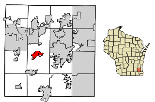
Hustisford is a village in Dodge County, Wisconsin, United States. The population was 1,101 at the 2020 census. The village is located within the town of Hustisford.

<span class="mw-page-title-main">Ripon, Wisconsin</span> City in Wisconsin, United States

Ripon is a city in Fond du Lac County, Wisconsin, United States. The population was 7,863 at the 2020 census. The city is surrounded by the Town of Ripon.

<span class="mw-page-title-main">Green Lake, Wisconsin</span> City in Wisconsin, United States

Green Lake is a city in and county seat of Green Lake County, Wisconsin, United States. The city had a population of 1,001 in the 2020 census. It is located on the north side of Green Lake. The Town of Green Lake is located on the south side of Big Green Lake, opposite the city.

<span class="mw-page-title-main">Princeton, Wisconsin</span> City in Wisconsin, United States

Princeton is a city in western part of Green Lake County, Wisconsin, United States. The population was 1,214 at the 2010 census. The city is located within the Town of Princeton. The Fox River flows through the city, dividing the city into an east half and west half.

<span class="mw-page-title-main">Lake Mills, Wisconsin</span> City in Wisconsin, United States

Lake Mills is a city in Jefferson County, Wisconsin, United States. The population was 6,211 at the 2020 census. The city is located partially within the Town of Lake Mills.

<span class="mw-page-title-main">Montello, Wisconsin</span> City in Wisconsin, United States

Montello is a city in and the county seat of Marquette County, Wisconsin, United States. The population was 1,495 at the 2010 census. The Fox River flows through the city. Montello is home to the largest tree in Wisconsin. A notable attraction in the city is the former granite quarry, which has been transformed into a park with several waterfalls.

<span class="mw-page-title-main">Omro, Wisconsin</span> City in Wisconsin, United States

Omro is a city in Winnebago County, Wisconsin, United States. The population was 3,517 at the 2010 census. The city is located along the Fox River, approximately 10 miles west of Oshkosh, Wisconsin.

<span class="mw-page-title-main">Bloomer, Wisconsin</span> City in Wisconsin, United States

Bloomer is a city in Chippewa County, Wisconsin, United States. As of the 2010 census, the population of the city of Bloomer was 3,539.

References

  1. "2019 U.S. Gazetteer Files". United States Census Bureau. Retrieved August 7, 2020.
  2. 1 2 U.S. Geological Survey Geographic Names Information System: Fox Lake, Wisconsin
  3. 1 2 "U.S. Census website". United States Census Bureau . Retrieved November 18, 2012.
  4. 1 2 "Population and Housing Unit Estimates". United States Census Bureau. May 24, 2020. Retrieved May 27, 2020.
  5. 1 2 "History of Fox Lake". City of Fox Lake. Archived from the original on February 3, 2014. Retrieved May 19, 2014.
  6. "Profile for Fox Lake, Wisconsin, WI". ePodunk. Archived from the original on May 15, 2019. Retrieved May 19, 2014.
  7. "US Gazetteer files: 2010, 2000, and 1990". United States Census Bureau. February 12, 2011. Retrieved April 23, 2011.
  8. "US Gazetteer files 2010". United States Census Bureau. Archived from the original on July 2, 2012. Retrieved November 18, 2012.
  9. "Census of Population and Housing". Census.gov. Retrieved June 4, 2015.
  10. "U.S. Census website". United States Census Bureau . Retrieved January 31, 2008.
  11. 1 2 "Bunny Berigan Jazz Jubilee". Bunny Berigan Jazz Jubilee. Retrieved May 19, 2014.
  12. "Dodge County Museums". Mayville Limestone School Museum. Retrieved May 19, 2014.
  13. "Waupun Area School District". Waupun Area School District. Retrieved May 19, 2014.
  14. "Waupun Area School District". GreatSchools Inc. Retrieved May 19, 2014.
  15. "St John's Lutheran School". GreatSchools Inc. Retrieved May 19, 2014.
  16. "St. John's Evangelical Lutheran Church and School". St. John's Evangelical Lutheran Church and School. Retrieved May 19, 2014.
  17. "Fox Lake Public Library". Fox Lake Public Library. Retrieved May 19, 2014.
  18. "Fox Lake Correctional Institution". Wisconsin Department of Corrections. Retrieved May 19, 2014.
  19. "WI Clintonville – Fox Lake". Small Town Claim to Fame. Archived from the original on March 4, 2016. Retrieved May 19, 2014.
  20. "Fox Lake was site of land office receiver". Beaver Dam daily Citizen. March 3, 2013. Retrieved May 19, 2014.
  21. Legislative Reference Bureau (1960). The Wisconsin Blue Book. Legislative Reference Bureau. p. 124.