Fond du Lac County is a county in the U.S. state of Wisconsin. As of the 2010 census, the population was 101,633. Its county seat is Fond du Lac. The county was created in the Wisconsin Territory in 1836 and later organized in 1844. Fond du Lac is French for "bottom of the lake", so given because of the county's location at the southern shore of Lake Winnebago. Fond du Lac County comprises the Fond du Lac, Wisconsin Metropolitan Statistical Area. The Holyland region is in northeastern Fond du Lac County.

Dodge County is a county located in the U.S. state of Wisconsin. As of the 2010 census, the population was 88,759. Its county seat is Juneau. The county was created from the Wisconsin Territory in 1836 and organized in 1844.

Columbia County is a county located in the U.S. state of Wisconsin. As of the 2010 census, the population was 56,833. Its county seat and largest city is Portage. The county was created in 1846 as part of Wisconsin Territory.

Juneau is a city in Dodge County, Wisconsin, United States. The population was 2,814 at the 2010 census. It is the county seat of Dodge County.

Woodland is a town in Sauk County, Wisconsin, United States. The population was 783 at the 2000 census. The unincorporated community of Valton is located in the town.

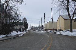
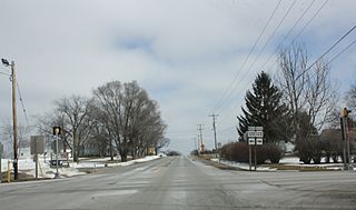
Lomira is a village in Dodge County, Wisconsin, United States. The population was 2,430 at the 2010 census. The village is located within the Town of Lomira, at the crossroads of State Highways 49, 67 and 175, and Interstate 41.

A county highway is a road in the United States and in the Canadian province of Ontario that is designated and/or maintained by the county highway department. Route numbering can be determined by each county alone, by mutual agreement among counties, or by a statewide pattern.
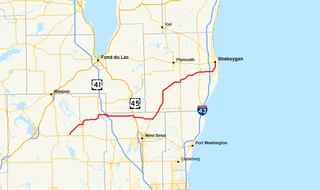
State Trunk Highway 28 is a 59.77-mile (96.19 km) state highway in Dodge, Washington, and Sheboygan counties in southeastern portion of the US state of Wisconsin that runs east–west between Horicon and Sheboygan. The route is generally two-lane road beyond portions of the road within the city of Sheboygan and the half-mile portion of the highway near Waldo which runs concurrently with Wisconsin Highway 57.
State Trunk Highway 109 was a 19.24-mile (30.96 km) state highway in southeastern Dodge County Wisconsin, United States, that ran north–south between Woodland and Watertown.

Collins is an unincorporated census-designated place in the town of Rockland, Manitowoc County, Wisconsin, United States, in the east central part of the state. Its zip code is 54207, although its post office is being studied for closure. As of the 2010 census, its population is 164. The Collins Marsh Wildlife Area is located east of the community. Wisconsin Highway 32 ran through the community; the route later became Wisconsin Highway 67 before it became County Highway W. County Highway JJ and the Wisconsin Central Ltd. railroad runs east–west through the community. Collins has an area of 0.496 square miles (1.28 km2), all of it land. The community was named for Sumner J. Collins, who was the general superintendent of the Wisconsin Central Railroad in the 1890s.

Dundee is an unincorporated community located in the town of Osceola, in Fond du Lac County, Wisconsin, United States. It is located on Wisconsin Highway 67 in the Kettle Moraine State Forest. The Kettle Moraine Scenic Drive runs through the community.
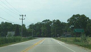
Taycheedah, Wisconsin is an unincorporated census-designated place in the Town of Taycheedah in Fond du Lac County, Wisconsin. The community is located adjacent to the city of Fond du Lac and Lake Winnebago. As of the 2010 census, its population is 704. Taycheedah calls itself the "Sheepshead Fishing Center of the World". U.S. Route 151 ran through the community until a bypass around Fond du Lac was built in the 2000s.

Garnet, Wisconsin is an unincorporated community in Fond du Lac County, in the U.S. state of Wisconsin. The community is on the north boundary of the county, just south of Calumet County. It is located at the intersection of County Highway HHH and Town Hall Road just east of Calumet County C, in the town of Calumet. Garnet is located 1.95 miles (3.14 km) east of Calumetville.

Greenville is a former unincorporated community located in the village of Greenville, in Outagamie County, Wisconsin, United States. Greenville is located at the intersection of Wisconsin Highway 76 and Wisconsin Highway 15.

LeRoy is an unincorporated community in the town of LeRoy in Dodge County, Wisconsin, United States. It is located at the intersection of County Y and County YY several miles west of Knowles.
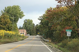
Sampson is an unincorporated community in Oconto County, Wisconsin, United States. The community is located at the intersection of Oconto County Highways C and D, in the town of Morgan. It is located at latitude 44.765 and longitude -88.186 and elevation 787 feet. In the unincorporated limits there is The Hilltop Tavern, a county highway shop and Sampson Valley Vineyard.

Burnett is an unincorporated census-designated place located in the town of Burnett, Dodge County, Wisconsin, United States. Burnett is located on Wisconsin Highway 26 5.5 miles (8.9 km) northwest of Horicon. Burnett has a post office with ZIP code 53922. As of the 2010 census, its population is 256.

Ashippun is an unincorporated census-designated place located in the town of Ashippun, Dodge County, Wisconsin, United States. Ashippun is located on Wisconsin Highway 67 7 miles (11 km) south of Neosho. Ashippun has a post office with ZIP code 53003. At the 2010 census, its population was 333.
Goerke's Corners is a former unincorporated community in the Town of Brookfield, in Waukesha County, Wisconsin, United States, at latitude 43°02'11" N and longitude 088°09'58" W. It is now the location of a major highway intersection, and the site of a park-and-ride lot.
Spring Prairie is an unincorporated community located in the town of Spring Prairie, Walworth County, Wisconsin, United States. Spring Prairie is located at the intersection of Wisconsin Highway 11 and Wisconsin Highway 120 7.25 miles (11.67 km) east of Elkhorn.