Brownsville, Wisconsin

Last updated

Brownsville, Wisconsin
Brownsville Wisconsin Looking East on WIS49.jpg
Looking east in Brownsville on Wisconsin Highway 49
Dodge County Wisconsin Incorporated and Unincorporated areas Brownsville Highlighted.svg
Location of Brownsville in Dodge County, Wisconsin.
Coordinates: 43°36′59″N88°29′26″W / 43.61639°N 88.49056°W / 43.61639; -88.49056 [1]
Country United States
State Wisconsin
County Dodge
Area
[2]
  Total0.61 sq mi (1.59 km2)
  Land0.61 sq mi (1.59 km2)
  Water0.00 sq mi (0.00 km2)
Elevation
[1]
997 ft (304 m)
Population
 (2020) [3]
  Total598
  Density975.5/sq mi (376.7/km2)
Time zone UTC-6 (Central (CST))
  Summer (DST) UTC-5 (CDT)
Area code 920
FIPS code 55-10450 [4]
GNIS feature ID1562277 [1]
Website www.villageofbrownsvilletoday.com

Brownsville is a village in Dodge County, Wisconsin, United States. The population was 598 at the 2020 census. [3]

Contents

Brownsville Fire Company station and equipment, c. 1963 Brownsville fire company 1963.png
Brownsville Fire Company station and equipment, c. 1963

History

The Village of Brownsville was first known as Thetis Station and had a narrow gauge railroad connection to Fond du Lac and Iron Ridge. In April 1878 the village was officially renamed to its current name, which was taken in honor of Alfred D. Brown, an English immigrant and pioneer farmer who in 1850 had settled an 80-acre farm on the edge of the village and became one of the first merchants there as well. The village remained unincorporated until it gained official status as an incorpated village on December 23, 1952. 1878 can therefore be regarded as the village's founding, with 1952 being its start as a proper municipality. As the town became more established towards the turn of the 20th Century, additional businesses and agricultural infrastructure were built, including crop storage bins and a grain elevator. In 1902 a small factory was built in town where it was used in local cheese production by various owners until the building was purchased by Michels Corporation in 1965, and demolished in 1973.

The Brownsville Fire Company, the local fire department, was organized in 1891 and originally consisted of 13 members and hook-and-ladder wagon with a hand-operated water pump. It was reorganized in October 1912. The first mechanical fire truck was purchased in 1931, a Studebaker pump truck which remains preserved today in local private ownership. The fire department today operates modern equipment, and responds to local and surrounding emergencies in collaboration with the emergancy services of other towns in Dodge and Fond du Lac counties.

The local Lutheran church, Saint Paul's Lutheran Church, began in 1885 when 15 local families from the congregation in Lomira (bearing the same name) were released to begin meeting as their own congregation. They built their first church building in 1887, which was located on Main Street next to the current cemetery until it was destroyed by a fire on September 6, 1909. The same year as the construction of the first church, the congregation elected a local Mr. Gottmanshausen as its first pastor, who accepted the call of the community. Reverend Gottmanshausen was installed on June 25, 1887. The current church, located a block away from the cemetery, was constructed in June 1915. It was completed in November later that year, and still stands in use today.

On August 28, 2018, an EF1 tornado caused major damage in the village. The tornado uprooted trees, tore siding off from buildings, damaged roofs, and downed power lines, among other destruction. The village was put under a state of emergency, with residents only being allowed in days after the tornado.

Geography

Sign for Brownsville Brownsville Wisconsin Sign looking east on WIS49.jpg
Sign for Brownsville

Brownsville is located two miles from US Hwy 41 and Wisconsin Highway 175. Wisconsin Highway 49 runs through the village.

Kummel Creek, a tributary of the Rock River, begins just north of the village and flows through the village.

According to the United States Census Bureau, the village has a total area of 0.52 square miles (1.35 km2), all of it land. [5]

Demographics

Historical population
CensusPop.Note
1960 276
1970 37435.5%
1980 43315.8%
1990 415−4.2%
2000 57037.3%
2010 5811.9%
2020 5982.9%
U.S. Decennial Census [6]

2010 census

As of the census [7] of 2010, there were 581 people, 221 households, and 175 families living in the village. The population density was 1,117.3 inhabitants per square mile (431.4/km2). There were 233 housing units at an average density of 448.1 per square mile (173.0/km2). The racial makeup of the village was 98.6% White, 0.3% African American, 0.3% Native American, 0.3% Asian, and 0.3% Pacific Islander. Hispanic or Latino of any race were 0.5% of the population.

There were 221 households, of which 37.6% had children under the age of 18 living with them, 70.1% were married couples living together, 7.2% had a female householder with no husband present, 1.8% had a male householder with no wife present, and 20.8% were non-families. 18.6% of all households were made up of individuals, and 5.9% had someone living alone who was 65 years of age or older. The average household size was 2.63 and the average family size was 2.99.

The median age in the village was 40.1 years. 25% of residents were under the age of 18; 7.9% were between the ages of 18 and 24; 25.4% were from 25 to 44; 30.6% were from 45 to 64; and 11% were 65 years of age or older. The gender makeup of the village was 50.6% male and 49.4% female.

2000 census

As of the census [4] of 2000, there were 570 people, 209 households, and 166 families living in the village. The population density was 1,467.3 people per square mile (564.3/km2). There were 213 housing units at an average density of 548.3 per square mile (210.9/km2). The racial makeup of the village was 99.30% White, 0.18% from other races, and 0.53% from two or more races. Hispanic or Latino of any race were 0.35% of the population.

There were 209 households, out of which 37.8% had children under the age of 18 living with them, 73.2% were married couples living together, 4.3% had a female householder with no husband present, and 20.1% were non-families. 17.7% of all households were made up of individuals, and 7.2% had someone living alone who was 65 years of age or older. The average household size was 2.73 and the average family size was 3.11.

In the village, the population was spread out, with 26.7% under the age of 18, 7.5% from 18 to 24, 33.7% from 25 to 44, 20.9% from 45 to 64, and 11.2% who were 65 years of age or older. The median age was 36 years. For every 100 females, there were 104.3 males. For every 100 females age 18 and over, there were 100.0 males.

The median income for a household in the village was $62,679, and the median income for a family was $65,441. Males had a median income of $40,625 versus $26,071 for females. The per capita income for the village was $22,452. None of the population or families were below the poverty line.

Michels Corporation Michels Corporation in Brownsville WI.jpg
Michels Corporation

Businesses

Brownsville contains a variety of businesses, including a bowling alley, a bar and grill, an apple orchard, a bank, a gas station, a dentist, and a medical clinic affiliated with SSM Health and Saint Agnes Hospital in Fond du Lac. The corporate headquarters of Michels Corporation is located in Brownsville. Public amenities include the local public library, two parks, baseball/softball diamonds and soccer fields, and a community center that functions both as a hub for community events as well as a rentable space for private events.

Civil service in the village includes the local fire department, a public works department, a police department consisting of one officer, and a post office. The interior of the local post office notably features photos of local residents who currently serve, or have previously served, in the United States Armed Forces. The village manages a water tower and a sewage disposal facility.

Related Research Articles

<span class="mw-page-title-main">Brownsville, Minnesota</span> City in Minnesota, United States

Brownsville is a city in Houston County, Minnesota, United States. The population was 566 at the 2020 census.

<span class="mw-page-title-main">Brandon, Wisconsin</span> Village in Wisconsin, United States

Brandon is a village in Fond du Lac County, Wisconsin, United States. The population was 879 at the 2010 census.

<span class="mw-page-title-main">Campbellsport, Wisconsin</span> Village in Wisconsin, United States

Campbellsport is a village in Fond du Lac County, Wisconsin, United States. The population was 2,016 at the 2010 census.

<span class="mw-page-title-main">North Fond du Lac, Wisconsin</span> Village in Wisconsin, United States

North Fond du Lac is a village in Fond du Lac County, Wisconsin, United States. The population was 5,378 at the 2020 census. Despite the name, North Fond du Lac is actually located northwest of Fond du Lac, as Lake Winnebago is directly north of Fond du Lac.

<span class="mw-page-title-main">St. Cloud, Wisconsin</span> Village in Wisconsin, United States

St. Cloud is a village in Fond du Lac County, Wisconsin, United States, along the Sheboygan River. The population was 477 at the 2010 census. St. Cloud is part of The Holyland region in northeastern Fond du Lac County.

<span class="mw-page-title-main">Barneveld, Wisconsin</span> Village in Wisconsin, United States

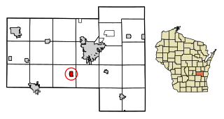
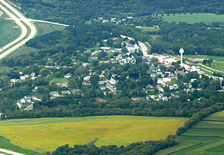
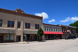
Barneveld is a village in Iowa County, Wisconsin, United States. The population was 1,331 at the 2020 census. It is part of the Madison Metropolitan Statistical Area.

<span class="mw-page-title-main">Maribel, Wisconsin</span> Village in Wisconsin, United States

Maribel is a village in Manitowoc County, Wisconsin, United States. The population was 336 at the 2020 census.

<span class="mw-page-title-main">Rothschild, Wisconsin</span> Village in Wisconsin, United States

Rothschild is a village in Marathon County, Wisconsin, United States. It is part of the Wausau, Wisconsin Metropolitan Statistical Area. The population was 5,567 at the 2020 census. Rothschild is the northern terminus of Interstate 39, which starts in Normal, Illinois.

<span class="mw-page-title-main">Spring Valley, Wisconsin</span> Village in Wisconsin, United States

Spring Valley is a village in Pierce and St. Croix counties in Wisconsin, United States. The population was 1,401 at the 2020 census. Of those, 1,390 were in Pierce County and 11 in St. Croix County. The village is mostly within the Town of Spring Lake in Pierce County. Small parts also lie in the Town of Gilman, also in Pierce County, and the Town of Cady in St. Croix County.

<span class="mw-page-title-main">Stockbridge, Wisconsin</span> Village in Wisconsin, United States

Stockbridge is a village in Calumet County, Wisconsin, United States. The population was 686 at the 2020 census. The village lies within the Town of Stockbridge.

<span class="mw-page-title-main">Deerfield, Wisconsin</span> City in Wisconsin, United States

Deerfield is a city in Dane County, Wisconsin. The population was 2,319 at the time of the 2010 census. The city is located within the Town of Deerfield. It is part of the Madison Metropolitan Statistical Area. Towns and villages near Deerfield include Marshall, Medina, London, Cambridge, and Cottage Grove, Wisconsin.

<span class="mw-page-title-main">Lomira, Wisconsin</span> Village in Wisconsin, United States

Lomira is a village in Dodge County, Wisconsin, United States. The population was 2,678 at the 2020 census. The village is located within the Town of Lomira, at the crossroads of State Highways 49, 67 and 175, and Interstate 41.

<span class="mw-page-title-main">Colfax, Wisconsin</span> Village in Wisconsin, United States

Colfax is a village in Dunn County, Wisconsin, United States. The population was 1,158 at the 2010 census. The village is surrounded by the Town of Colfax.

<span class="mw-page-title-main">Oakfield, Wisconsin</span> Village in Wisconsin, United States

Oakfield is a village in Fond du Lac County, Wisconsin, United States. The population was 1,052 at the 2020 census. The village is located within the Town of Oakfield.

<span class="mw-page-title-main">Ridgeway, Wisconsin</span> Village in Wisconsin, United States

Ridgeway is a village in Iowa County, Wisconsin, United States. The population was 624 at the 2020 census. The village is adjacent to the Town of Ridgeway. It is part of the Madison Metropolitan Statistical Area.

<span class="mw-page-title-main">Osceola, Wisconsin</span> Village in Wisconsin, United States

Osceola is a village in Polk County, Wisconsin, United States. The population was 2,765 at the 2020 census. Located mostly within the Town of Osceola, the village sits on the border with Minnesota, separated by the St. Croix River. It is along Wisconsin Highway 35.

<span class="mw-page-title-main">Clinton (village), Rock County, Wisconsin</span> Village in Wisconsin, United States

Clinton is a village in Rock County, Wisconsin, United States. The population was 2,221 in the 2020 census. The village is located within the town of Clinton. The Norwegian-American Jefferson Prairie Settlement was located near the village.

<span class="mw-page-title-main">Couderay, Wisconsin</span> Village in Wisconsin, United States

Couderay is a village in Sawyer County, Wisconsin, United States, along the Couderay River. The population was 88 at the 2010 census. The village is located within the Town of Couderay.

<span class="mw-page-title-main">Aniwa, Wisconsin</span> Village in Wisconsin, United States

Aniwa is a village in Shawano County, Wisconsin, United States. The population was 260 at the 2010 census. The village is located within the Town of Aniwa. U.S. Route 45 runs north–south through the village.

<span class="mw-page-title-main">Eagle, Wisconsin</span> Village in Wisconsin, United States

Eagle is a village in Waukesha County, Wisconsin, United States. At the 2020 census, the population was 2,071. The village is located within the Town of Eagle.

References

  1. 1 2 3 U.S. Geological Survey Geographic Names Information System: Brownsville, Wisconsin
  2. "2020 U.S. Gazetteer Files". United States Census Bureau. Retrieved March 22, 2024.
  3. 1 2 "Profile of General Population and Housing Characteristics: 2020 Demographic Profile Data (DP-1): Brownsville village, Wisconsin". United States Census Bureau . Retrieved March 22, 2024.
  4. 1 2 "U.S. Census website". United States Census Bureau . Retrieved January 31, 2008.
  5. "US Gazetteer files 2010". United States Census Bureau. Archived from the original on July 2, 2012. Retrieved November 18, 2012.
  6. "Census of Population and Housing". Census.gov. Retrieved June 4, 2015.
  7. "U.S. Census website". United States Census Bureau . Retrieved November 18, 2012.