
The Oregon Trail is a 2,170-mile (3,490 km) historic East–West, large-wheeled wagon route and emigrant trail in the United States that connected the Missouri River to valleys in Oregon. The eastern part of the Oregon Trail spanned part of the future state of Kansas, and nearly all of what are now the states of Nebraska and Wyoming. The western half of the trail spanned most of the future states of Idaho and Oregon.
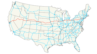
Interstate 80 (I-80) is an east–west transcontinental freeway in the United States that runs from downtown San Francisco, California, to Teaneck, New Jersey, in the New York City Metropolitan Area. The highway was designated in 1956 as one of the original routes of the Interstate Highway System. Its final segment was opened to traffic in 1986. It is the second-longest Interstate Highway in the United States, following I-90. The Interstate runs through many major cities including Oakland, Reno, Salt Lake City, Omaha, Des Moines, and Toledo, and passes within 10 miles (16 km) of Chicago, Cleveland, and New York City.

Fort Bridger is a census-designated place (CDP) in Uinta County, Wyoming, United States. The population was 345 at the 2010 census. The town takes its name from the eponymous Fort Bridger established in 1842.

Fort Laramie was a significant 19th-century trading post and diplomatic site located at the confluence of the Laramie and the North Platte rivers. They joined in the upper Platte River Valley in the eastern part of the U.S. state of Wyoming. The fort was founded as a private trading post in the 1830s to service the overland fur trade. It was located east of the long climb leading to the best and lowest crossing point of the Rocky Mountains at South Pass and became a popular stopping point for migrants on the Oregon Trail. Along with Bent's Fort on the Arkansas River, the trading post and its supporting industries and businesses were the most significant economic hub of commerce in the region.

The Great Divide Basin or Great Divide Closed Basin is an area of land in Wyoming's Red Desert where none of the water falling as rain to the ground drains into any ocean, directly or indirectly. It is therefore considered an endorheic basin, and it adjoins the Continental Divide in southern Wyoming. To the west of the basin is the Green River watershed, draining to the Gulf of California/Pacific Ocean; to the north is the North Platte watershed, draining to the Gulf of Mexico/Atlantic Ocean. The basin is very roughly rectangular in shape; the northwest corner is at Oregon Buttes near South Pass, about 40 miles (64 km) southwest of Lander, and the southeast corner is in the Sierra Madre Range near Bridger Pass, about 20 miles (32 km) southwest of Rawlins.

The Laramie Plains is an arid highland at an elevation of approx. 8,000 feet (2,400 m) in south central Wyoming in the United States. The plains extend along the upper basin of the Laramie River on the east side of the Medicine Bow Range. The city of Laramie is the largest community in the valley. The plains are separated from the Great Plains to the east by the Laramie Mountains, a spur of the Front Range that extends northward from Larimer County, Colorado west of Cheyenne. The high altitude of the region makes for a cold climate and a relatively short growing season. Unsuitable to most cultivation, the plains have historically been used for livestock raising, primarily of sheep and cattle.

The Mount Hood Highway No. 26 is the Oregon Department of Transportation's designation for a 93.84-mile (151.02 km) highway from Portland east around the south side of Mount Hood and north via Bennett Pass to Hood River. It is marked as U.S. Route 26 from Portland to near Mount Hood and Oregon Route 35 the rest of the way to Hood River.

The Archway is a monument that features a historical exhibit of Nebraska's and the Platte River Valley's role in the building of America. The Archway spans more than 300 feet over Interstate 80 three miles (5 km) east of Kearney, Nebraska. A new exit immediately east of The Archway provides easy access. Exit 272 also provides access to The Archway.
Interstate 80 (I-80) is a part of the Interstate Highway System that runs from San Francisco to Teaneck, New Jersey. In Wyoming, the Interstate Highway runs 402.780 miles (648.212 km) from the Utah state line near Evanston east to the Nebraska state line in Pine Bluffs. I-80 connects Cheyenne, Wyoming's capital and largest city, with several smaller cities along the southern tier of Wyoming, including Evanston, Green River, Rock Springs, Rawlins, and Laramie. The highway also connects those cities with Salt Lake City to the west and Omaha to the east. In Cheyenne, I-80 intersects I-25 and has Wyoming's only auxiliary Interstate, I-180. The Interstate runs concurrently with U.S. Route 30 for most of their courses in Wyoming. I-80 also has shorter concurrencies with US 189 near Evanston, US 191 near Rock Springs, and US 287 and Wyoming Highway 789 near Rawlins. The Interstate has business loops through all six cities along its course as well as a loop serving Fort Bridger and Lyman east of Evanston.
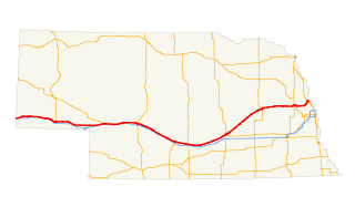
Interstate 80 (I-80) in the U.S. state of Nebraska runs east from the Wyoming state border across the state to Omaha. When it completed construction of the stretch of I-80 spanning the state on October 19, 1974, Nebraska was the first state in the nation to complete its mainline Interstate Highway System.
U.S. Highway 30 (US 30) is part of the United States Numbered Highway System that runs for 3,073 miles (4,946 km) from Astoria, Oregon to Atlantic City, New Jersey. Within the state of Nebraska it is a state highway that travels 451.74 miles (727.01 km) west to east across the state from the Wyoming state line west of Bushnell to the Missouri River in Blair on the Iowa state line. For much of its length it travels within the Platte River valley, adjacent or near the river between Brule and Fremont, a distance of just over 300 miles (480 km). This corridor was also highly traveled during Westward Expansion along the California and Oregon Trails, it was also used by the Pony Express and the Transcontinental Railroad. The landscape is dominated by vast agricultural fields within the fertile Platte River valley across the center of the state, while the western portion passes through higher plains and the eastern portion through the rolling hills adjacent to the Missouri River valley.

The path followed by the Oregon Trail, California Trail and Mormon Trail spans 400 miles (640 km) through the U.S. state of Wyoming. The trail entered from Nebraska on the eastern border of the state near the present day town of Torrington and exited on the western border near the towns of Cokeville and Afton. An estimated 350,000 to 400,000 settlers traveled on the trail through Wyoming between 1841 and 1868. All three trails follow the same path through most of the state. The Mormon Trail splits at Fort Bridger and enters Utah, while the Oregon and California Trails continue to Idaho.

The Great Platte River Road was a major overland travel corridor approximately following the course of the Platte River in present-day Nebraska and Wyoming that was shared by several popular emigrant trails during the 19th century, including the Trapper's Trail, the Oregon Trail, the Mormon Trail, the California Trail, the Pony Express route, and the military road connecting Fort Leavenworth and Fort Laramie. The road, which extended nearly 800 miles (1,300 km) from the Second Fort Kearny to Fort Laramie, was utilized primarily from 1841 to 1866. In modern times it is often regarded as a sort of superhighway of its era, and has been referred to as "the grand corridor of America's westward expansion".
Business routes of Interstate 80 exist in four states; California, Nevada, Utah, and Wyoming.
The Overland Trail was a stagecoach and wagon trail in the American West during the 19th century. While portions of the route had been used by explorers and trappers since the 1820s, the Overland Trail was most heavily used in the 1860s as an alternative route to the Oregon, California, and Mormon trails through central Wyoming. The Overland Trail was famously used by the Overland Stage Company owned by Ben Holladay to run mail and passengers to Salt Lake City, Utah, via stagecoaches in the early 1860s. Starting from Atchison, Kansas, the trail descended into Colorado before looping back up to southern Wyoming and rejoining the Oregon Trail at Fort Bridger. The stage line operated until 1869 when the completion of the First Transcontinental Railroad eliminated the need for mail service via Thais' stagecoach.
Howard Stansbury was a major in the U.S. Army Corps of Topographical Engineers. His most notable achievement was leading a two-year expedition (1849–1851) to survey the Great Salt Lake and its surroundings. The expedition report entitled Exploration and survey of the valley of the Great Salt Lake of Utah, including a reconnaissance of a new route through the Rocky Mountains was published in 1852 providing the first serious scientific exploration of the flora and fauna of the Great Salt Lake Valley as well as a favorable impression of the members of The Church of Jesus Christ of Latter-day Saints, who had settled there beginning in 1847.
In the American Old West overland trails were popular means of travel used by pioneers and immigrants throughout the 19th century and especially between 1830 and 1870 as an alternative to sea and railroad transport. These immigrants began to settle North America west of the Great Plains as part of the mass overland migrations of the mid-19th century. Settlers emigrating from the eastern United States were spurred by various motives, among them religious persecution and economic incentives. After the end of the Mexican–American War in 1849, vast new American conquests again enticed mass immigration. Legislation like the Donation Land Claim Act and significant events like the California Gold Rush further lured people to travel overland to the west.
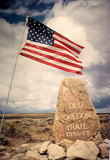
The historic 2,170-mile (3,490 km) Oregon Trail connected various towns along the Missouri River to Oregon's Willamette Valley. It was used during the 19th century by Great Plains pioneers who were seeking fertile land in the West and North.

The South Platte River Trail Scenic and Historic Byway is located in Sedgwick County in northeastern Colorado, just south of the border with Nebraska. It follows the historic trails used during westward expansion. Its 19-mile (31 km) route, which includes County Road 28 (CR 28) and U.S. Highway 138 (US 138), connects Ovid and Julesburg and encircles the South Platte River. It was designated a Colorado Scenic and Historic Byway in 1991.


