
America's first transcontinental railroad was a 1,911-mile (3,075 km) continuous railroad line built between 1863 and 1869 that connected the existing eastern U.S. rail network at Council Bluffs, Iowa, with the Pacific coast at the Oakland Long Wharf on San Francisco Bay. The rail line was built by three private companies over public lands provided by extensive U.S. land grants. Building was financed by both state and U.S. government subsidy bonds as well as by company-issued mortgage bonds. The Western Pacific Railroad Company built 132 miles (212 km) of track from the road's western terminus at Alameda/Oakland to Sacramento, California. The Central Pacific Railroad Company of California (CPRR) constructed 690 miles (1,110 km) east from Sacramento to Promontory Summit, Utah Territory. The Union Pacific Railroad (UPRR) built 1,085 miles (1,746 km) from the road's eastern terminus at the Missouri River settlements of Council Bluffs and Omaha, Nebraska, westward to Promontory Summit.

Uinta County is a county in the U.S. state of Wyoming. As of the 2020 United States Census, the population was 20,450. Its county seat is Evanston. Its south and west boundary lines abut the Utah state line.

Evanston is a city in and the county seat of Uinta County, Wyoming, United States. The population was 11,747 at the 2020 census. It is located near the border with Utah.
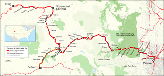
The Denver and Salt Lake Railway (D&SL) was a U.S. railroad company located in Colorado. Originally incorporated in 1902 as the Denver, Northwestern and Pacific (DN&P) Railway, it had as a goal a direct connection of Denver, Colorado, with Salt Lake City, Utah. It underwent numerous reorganizations throughout its financially troubled history and by the time the company was acquired in 1931 by the Denver and Rio Grande Western Railroad, it had advanced only as far as Craig, Colorado. After the acquisition the line was connected to the D&RGW main, and the eastern half of the line was used to give the D&RGW a more direct route to Denver. The portions of the railroad still in use today are known as the Moffat Tunnel Subdivision of Union Pacific Railroad's Central Corridor. Amtrak’s California Zephyr service from Denver to Glenwood Springs follows much of the old D&SL route.
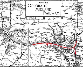
The Colorado Midland Railway, incorporated in 1883, was the first standard gauge railroad built over the Continental Divide in Colorado. It ran from Colorado Springs to Leadville and through the divide at Hagerman Pass to Glenwood Springs and Grand Junction.

Thistle is a ghost town in Spanish Fork Canyon in southeastern Utah County, Utah, United States. During the era of steam locomotives, the town's primary industry was servicing trains for the Denver and Rio Grande Western Railroad. The fortunes of the town were closely linked with those of the railroad until the changeover to diesel locomotives, when the town started to decline.

Soldier Summit is the name of both a mountain pass in the Wasatch Mountains in Utah, United States and an unincorporated community that is a near-ghost town located at the pass. Soldier Summit has been an important transportation route between the Wasatch Front and Price, Utah, since the area was settled by the Mormon pioneers. It is on the route of both U.S. Route 6 and the old main line of the Denver and Rio Grande Western Railroad (D&RGW), now the Provo Subdivision of the Central Corridor. Located where the road makes a brief bend through the extreme southwest corner of Wasatch County, Soldier Summit historically had more to do with nearby Utah County.

Interstate 80 (I-80) is a part of the Interstate Highway System that runs from San Francisco, California, to Teaneck, New Jersey. In Wyoming, the Interstate Highway runs 402.76 miles (648.18 km) from the Utah state line near Evanston east to the Nebraska state line in Pine Bluffs. I-80 connects Cheyenne, Wyoming's capital and largest city, with several smaller cities along the southern tier of Wyoming, including Evanston, Green River, Rock Springs, Rawlins, and Laramie. The highway also connects those cities with Salt Lake City to the west and Omaha to the east. In Cheyenne, I-80 intersects I-25 and has Wyoming's only auxiliary Interstate, I-180. The Interstate runs concurrently with US Highway 30 (US 30) for most of their courses in Wyoming. I-80 also has shorter concurrencies with US 189 near Evanston, US 191 near Rock Springs, and US 287 and Wyoming Highway 789 (WYO 789) near Rawlins. The Interstate has business loops through all six cities along its course as well as a loop serving Fort Bridger and Lyman east of Evanston.

Kelton is a ghost town, just north of the Great Salt Lake, in the Park Valley area of Box Elder County, Utah, United States. The town was inhabited during the period of 1869–1942. Once an important section station on the First transcontinental railroad, Kelton was dependent on the railroad throughout its history. The town suffered serious setbacks in the 1880s when its busy stagecoach route to Boise, Idaho was discontinued, and in the 1900s when the Lucin Cutoff left it off the main rail line. The strongest earthquake in Utah history caused severe damage in 1934, but Kelton ceased to exist only when the rails were completely removed during World War II.

Mill Fork is a ghost town located approximately 12 miles (19 km) east of Thistle in Spanish Fork Canyon in Utah County, Utah, United States. Named for its sawmills, Mill Fork was important in the development of the railroad through the canyon. The arched entrance to the small, well-tended Mill Fork Cemetery is a landmark on U.S. Route 6 between the cities of Spanish Fork and Price.

Forest City is a ghost town in Utah County, Utah, United States. It is located in the valley of Dutchman Flat in the upper part of American Fork Canyon, in the Uinta National Forest. A silver mining town just over the mountain from Alta, Forest City was inhabited about 1871–1880. The town grew up around the smelter that was built to process ore from the canyon's mines. The American Fork Railroad, which was intended to serve Forest City and the smelter, stopped short of its destination due to engineering difficulties. Transportation costs rose too high for the mines to continue operating profitably. As the smelter, mines, and railroad closed down, Forest City was abandoned.

The Overland Route was a train route operated jointly by the Union Pacific Railroad and the Central Pacific Railroad/Southern Pacific Railroad, between the eastern termini of Council Bluffs, Iowa, and Omaha, Nebraska, and the San Francisco Bay Area, over the grade of the first transcontinental railroad which opened on May 10, 1869. Passenger trains that operated over the line included the Overland Flyer, later renamed the Overland Limited, which also included a connection to Chicago.

Interstate 80 Business may refer to several business routes of the Interstate Highway System that connects Interstate 80 with the central business district of various cities bypassed by I-80. The business route in each community is considered a unique route. In many cases, these routes are a former section of a U.S. Route or state highway.

Wahsatch is a ghost town in Summit County, Utah, United States. It lies along I-80 at the northeastern end of Echo Canyon some 23 miles (37 km) east of Echo, and 11 miles (18 km) west of Evanston, Wyoming. Wahsatch was established as a railroad camp, later achieving local prominence in sheep ranching. It was inhabited from 1868 until the 1930s.

This is a list of the National Register of Historic Places listings in Uinta County, Wyoming.
Bridger Valley is a landform of Uinta County, Wyoming, United States, where Fort Bridger was established in 1843 to service emigrant traffic. For the next century, the region served as a crossroads for the "California/Oregon Trail, the Mormon Trail, the Pony Express Route, the Transcontinental Railroad, and the Lincoln Highway. Today, the valley is a historic byway, incorporating the small towns of Fort Bridger, Urie, Mountain View, and Lyman". Bridger Valley Historic Byway is an approximately 20 miles (32 km) loop showcasing some of Wyoming's most treasured historical sites.
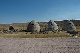
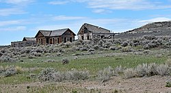
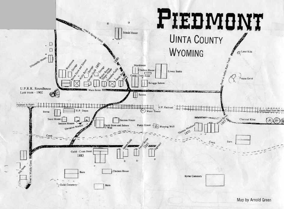
The Piedmont Charcoal Kilns in Piedmont, Wyoming, are a remnant of a once-extensive charcoal-making industry in southwestern Wyoming. The kilns were built by Moses Byrne around 1869 near the Piedmont Station along the Union Pacific Railroad. The three surviving beehive-shaped kilns were built of local sandstone about 30 feet (9.1 m) in circumference and about 30 feet (9.1 m) high, with 24-inch-thick (61 cm) walls. A granite marker reads:
Charcoal Kilns were built by Moses Byrne, 1869, to supply the pioneer smelters in the Utah Valley.
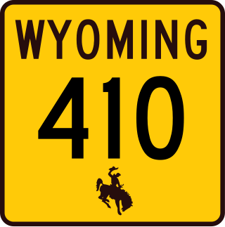
Wyoming Highway 410 (WYO 410) is a 13.36-mile (21.50 km) state highway in Uinta County, Wyoming, United States, that connects areas west of Roberston with Mountain View.
Sherman is a ghost town in Albany County, Wyoming, United States. Sherman is 19 miles (31 km) southeast of Laramie in the Laramie Mountains and is named for Civil War general William Tecumseh Sherman, purportedly at his request. From the 1860s to 1918, the town sat at the summit of the original grade of the first transcontinental railroad along the rails of the Union Pacific Railroad, at an elevation of 8,247 ft (2,514 m).
The Uinta Basin Rail project is a proposed 100-mile (160 km) rail line to connect the shale oil rich Uinta Basin region of eastern Utah to the national rail network. Numerous proposals have been made, some as far back as 1902, that are still under consideration. The current effort is a public-private partnership between a coalition of 7 counties in Utah, the Rio Grande Pacific Corporation and Drexel Hamilton Infrastructure Partners. The railroad is also backed by the Ute Tribe who hold a 5% stake in the project. If the rail line is built it will be the first major greenfield rail line built in the United States since the Chicago and North Western’s line to the Powder River Basin was built in the early 1980s. The Surface Transportation Board approved construction of the line in December 2021, but in August 2023, a Federal Appeals Court halted the project pending "a more fulsome explanation for the Board’s conclusion that the Railway’s transportation benefits outweighed the project’s environmental impacts".


