Broad Street (Columbus, Ohio)

Last updated
Broad Street
Discovery Bridge, Columbus, Ohio 01.jpg
Broad Street over the Discovery Bridge heading east into downtown
Location Franklin, Licking, Madison counties, Ohio
West end West Jefferson, Ohio
East end Pataskala, Ohio
NorthGay Street
SouthVaries

Broad Street is a major thoroughfare in Central Ohio, predominantly in Franklin County and Columbus. It stretches east from West Jefferson at Little Darby Creek to Pataskala. The street is considered one of Columbus's two main roads, along with High Street.

Contents

Broad Street was first laid out around 1797, when Franklinton was settled. In 1812, when Columbus was founded, a new section of the street was built in the new city. The street first connected to the rest of the settled country in 1831, when the Ohio and Erie Canal reached Columbus. In 1833, the National Road was extended to Columbus, utilizing all of West Broad Street. In the mid-to-late 19th century, East Broad Street became a fashionable place for wealthy homeowners, and large mansions were built along the tree-lined street. Large hotels and apartments followed into the early 1900s. The street has seen numerous changes since then, including clearing and widening. Portions of the street were improved with trees, bike lanes, and rainwater basins in Franklinton, with additional streetscape improvements planned for other sections of the street.

Route description

Broad Street looking east from downtown Columbus U.S. 40 from Rhodes Tower 2019.jpg
Broad Street looking east from downtown Columbus

Broad Street extends east and west far into Ohio, though it is named Broad Street starting at the eastern end of West Jefferson, Ohio (in Madison County). Continuing east, the road quickly enters Franklin County and passes by Lake Darby in Prairie Township. At about this point it passes into a portion of Columbus's municipal boundaries, though passes out to New Rome and Lincoln Village, both settlements that are part of Prairie Township. From there it passes through a series of Columbus neighborhoods. First is Hilltop, a large neighborhood in Columbus. It then passes through Franklinton. The road passes Franklinton and crosses the Scioto River on the Discovery Bridge, entering Downtown Columbus. Within Downtown, it first passes through the Civic Center followed by Capitol Square. It continues east through the Discovery District before exiting Downtown, crossing over Interstate 71 on a bridge known simply as the Broad Street bridge. It then passes through the city's Near East Side neighborhood, which has King-Lincoln Bronzeville immediately to the north and Olde Towne East and Franklin Park to the south. Broad Street then enters Bexley, a suburban city that is an enclave of Columbus. The road continues into a small area of Columbus again, an area that includes the Broadleigh neighborhood. It then passes into Whitehall, another enclave of Columbus. It resumes east into the easternmost portions of the city, where it then enters Pataskala, a small city, as well as Licking County. Broad Street terminates at the east end of the city, continuing on as Ohio Route 16 into Granville. [1]

History

Broad Street (running roughly east to west) has always been one of the city's main thoroughfares. The other, High Street, runs roughly north to south. Columbus Plan 16.jpg
Broad Street (running roughly east to west) has always been one of the city's main thoroughfares. The other, High Street, runs roughly north to south.

Broad Street has been one of Columbus's two main corridors since its founding, along with High Street, meeting at a 100 percent corner downtown. [2] The street has its origin before High Street and Columbus, with the 1797 founding of Franklinton. The first section of the road was constructed then, on the west bank of the Scioto River. Franklinton, then an independent settlement, had applied to be Ohio's capital. The settlement's founders were persuasive, though its flood problem led Ohio officials to choose the eastern bank of the river, on higher ground. Several streets were then laid out from the city's founding in 1812 into the following year, including Broad and High. [3] These streets and the entire grid were laid out 12 degrees off from a north–south and east–west alignment. [4] Broad Street's construction involved clearing dense forest, and tree stumps left behind caused horse-drawn carriages to maneuver around them, helping lead to the wide roadway. [3]

In the city's early years, it was isolated from the rest of Ohio and the country. This was first remedied in 1831 with the opening of the Ohio and Erie Canal's Columbus Feeder Canal. [5] In 1833, another connection began to benefit the city. The National Road, a project begun in 1806, reached the city in 1833; it utilized all of West Broad Street up to High Street, where it continued south and east. [3]

Early in Columbus's history, around the mid-1800s, East Broad Street became one of the most fashionable places to live, from downtown past Franklin Park. This carried into the early 1900s, when grand hotels and apartment buildings like the Royal York and Brunson Place were built. One early house from 1838, the Alfred Kelley mansion, was torn down and replaced with the Christopher Inn around 1961, itself torn down in 1988. [6] [7]

Broad (left) and High (right) extending east and south through Columbus past the Ohio Statehouse, 1893 Ohio Statehouse Grounds from Broad Street and High Street.jpg
Broad (left) and High (right) extending east and south through Columbus past the Ohio Statehouse, 1893

Beginning in 1857, a large portion of the downtown stretch was converted into a lush boulevard with tree-lined medians. Local businessman William Deshler designed the streetscape after he saw tree-lined boulevards in Paris. The road was still made up of dirt and not significantly changed until 1873, when gravel and broken rock was added. In the early 1930s, with increasing automobile traffic, the streetscape was viewed as an obstacle or danger. Careless drivers would commonly crash into the road's trees, suffering injuries or deaths. Thus in 1932, after a public vote, the trees were cut down, the medians removed, and the street was widened by two lanes. Around the 1970s, Columbus mayor Tom Moody commissioned Vincent Ponte to redesign downtown Broad Street. Ponte proposed a similar parkway to what was built in the 1850s, but a lack of funding and concerns of impeding traffic caused the plan to not be carried forward. [3] Starting around the 1980s, the remaining mansions on East Broad Street began to be repaired and restored to their original integrity. [6]

In 1992, with the AmeriFlora '92 exposition approaching, the city again considered reworking Broad Street, including transit options or a parkway with medians. Again in the late 1990s and early 2000s, with a declining downtown population, Mayor Michael B. Coleman commissioned $10 million in studies. Coleman was the first mayor in years to promote walkable urban living, and the plan and its timetable continued, though continually pushed back and overlooked during the 2007-2009 Great Recession. The city's 2010 strategic plan again pushed for a walkable, narrowed Broad Street, among many other projects. With the redevelopment of Franklinton in the 2000s into the present day, some of the first streetscape improvements took place. In 2017, the city created a tree-lined median, painted bike lanes, two-way turn lanes, and grassy rainwater basins around a stretch of Broad Street just west of downtown. The work was intended to safely bridge two of the city's riverfront-area museums: COSI and the National Veterans Memorial and Museum. In 2019, the city announced it will continue the process through the extent of Franklinton, though without the planted medians. [3]

Attributes

The street in Franklinton, west of Downtown Broad Street in Franklinton.jpg
The street in Franklinton, west of Downtown

Broad Street and High Street both traverse beyond the extent of the city; High Street is the longest in Columbus, running 13.5 mi (21.7 km) (23.4 across the county), while Broad Street is longer across the county, at 25.1 mi (40.4 km). [2] The city's street plan follows a grid pattern with the intersection of Broad and High Streets at its center. [8] The address system begins its numbering at the intersection of Broad and High, with numbers increasing in magnitude with distance from Broad or High, as well as cardinal directions used alongside street names. [9]

The street is named for its broad width; it was originally laid out to be 120 ft (37 m) wide. High Street was 100 feet wide, while most others were 82.5 feet, and alleys were 33 feet wide. [4] Broad St. is among the widest streets in Columbus, with significant portions four to six lanes wide, often with additional parking or bike lanes. The city has discussed narrowing the road for pedestrian safety for decades. [3] The street has a reputation as dangerous to cross without a walk sign, especially portions of West Broad that have large stretches without stoplights where cars speed by. [10]

A 10 E Broad / W Broad bus in Franklinton COTA XN40 bus.jpg
A 10 E Broad / W Broad bus in Franklinton

U.S. Routes 40 and 62 utilize Broad Street around downtown Columbus. For public transportation, the Central Ohio Transit Authority's Route 10 runs down most of Broad Street. [11] Before the authority was created, the same route was operated by private transit companies with bus lines, and before that, streetcars and horsecars.

Beside the historic landmarks listed below, the street has numerous cultural landmarks and attractions. These include the National Veterans Memorial and Museum, COSI, the Scioto Mile park system, the Discovery Bridge, Columbus City Hall, the Rhodes State Office Tower, Franklin County Memorial Hall, the Washington Gladden Social Justice Park, and Franklin Park.

Historical landmarks

Buildings on Broad Street can have one of several types of official landmark designations:

Individual landmarks

Below is a list of historic sites on Broad Street, from west to east. Historic districts are not included in this table, but are mentioned in § Historic districts. Buildings within historic districts, but no individual landmark designation, are not included in this table.

NameImageAddressNeighborhoodCRHPNRHPNotes
Central Ohio Lunatic Asylum Insane Asylum, Columbus, O (b).tif 1960 West Broad St. Hilltop YesDemolished by 1996
Franklinton Apartments at Broad and Hawkes Franklinton Apartments at Broad and Hawkes.jpg 949-957 West Broad St. Franklinton Yes
Gen. William Henry Harrison Headquarters / Sullivant Land Office Harrison House in Franklinton 25.jpg 570 West Broad St. Franklinton YesYes
Engine House No. 6 Columbus Engine House No. 6.jpg 540 West Broad St. Franklinton Yes
Toledo and Ohio Central Railroad Station Columbus, OH train station.jpg 379 West Broad St. Franklinton Yes
Central High School Central High School 1.jpg 75 South Washington Blvd. Franklinton YesYes
LeVeque Tower LeVeque Tower, Columbus, OH, US crop.jpg 50 West Broad St. Downtown YesYes
Wyandotte Building Wyandotte Building in Columbus.jpg 21 West Broad St. Downtown Yes
New Hayden Building New Hayden Building.jpg 16 East Broad St. Downtown Yes
Hayden Building Columbus - The Hayden (OHPTC) - 44486602260.jpg 20 East Broad St. Downtown Yes
Ohio Statehouse Ohio Statehouse 03.jpg 1 Capitol Square Downtown YesYesAlso a National Historic Landmark
Chase Tower Chase Bank Tower, Columbus, OH - 48310695242.jpg 100 East Broad St. Downtown Yes
Trinity Episcopal Church Trinity Episcopal, Columbus.jpg 125 East Broad St. Downtown YesYes
Athletic Club of Columbus Athletic Club of Columbus from southwest.jpg 136 East Broad St. Downtown Yes
Empire Building Yuster Building - Columbus Ohio.jpg 150 East Broad St. Downtown Yes
Benjamin Smith House Benjamin Smith House 01.jpg 181 East Broad St. Downtown Yes
St. Joseph Cathedral St. Joseph's Cathedral, Columbus.jpg 212 East Broad St. Downtown Yes
Seneca Hotel Columbus ohio seneca hotel.JPG 361 East Broad St. Downtown YesYes
First Congregational Church Columbus, Ohio (2018) - 422.jpg 444 East Broad St. Downtown Yes
Columbus Museum of Art Columbus Museum of Art 06.jpg 480 East Broad St. Downtown Yes
Broad Street United Methodist Church Broad Street United Methodist Church.jpg 501 East Broad St. Downtown YesYes
Ohio Farm Bureau Federation Offices Columbus-620-630 East Broad (OHPTC) - 7845108310.jpg 620, 630 East Broad St. Downtown Yes
Frederick Prentiss House Frederick Prentiss House replacement.jpg 706 East Broad St. King-Lincoln Bronzeville YesDemolished, site pictured
W.H. Jones Mansion Columbus ohio wh jones mansion.jpg 731 East Broad St. Olde Towne East YesYes
Central Assurance Company Central Assurance Company.jpg 741 East Broad St. Olde Towne East Yes
East Broad Street Commercial Building East Broad Street Commercial Building.jpg 747, 749, 751 East Broad St. Olde Towne East Yes
House at 753 East Broad Street House at 753 East Broad Street.jpg 753 East Broad St. Olde Towne East Yes
East Broad Street Presbyterian Church East Broad Street Presbyterian Church, blue sky.jpg 760 East Broad St. King-Lincoln Bronzeville Yes
Garfield-Broad Apartments Garfield-Broad Apartments.jpg 775 East Broad St. Olde Towne East Yes
Joseph-Cherrington House Joseph-Cherrington House.jpg 785 East Broad St. Olde Towne East Yes
Saint Paul's Episcopal Church Former Saint Paul's Episcopal Church on East Broad Street.jpg 787 East Broad St. Olde Towne East Yes
Carrie Lovejoy House Carrie Lovejoy House.jpg 807 East Broad St. Olde Towne East Yes
C.E. Morris House Columbus ohio ce morris house.jpg 875 East Broad St. Olde Towne East Yes
Broad Street Apartments Broad Street Apartments.jpg 880-886 East Broad St. King-Lincoln Bronzeville Yes
Erwin W. Schueller House Erwin W. Schueller House.jpg 904 East Broad St. King-Lincoln Bronzeville Yes
Linus B. Kauffman House Linus B. Kauffman House.jpg 906 East Broad St. King-Lincoln Bronzeville Yes
Cambridge Arms Cambridge Arms.jpg 926 East Broad St. King-Lincoln Bronzeville Yes
Soloman Levy House Soloman Levy House.jpg 929 East Broad St. Olde Towne East Yes
Sharp-Page House Sharp-Page House.jpg 935 East Broad St. Olde Towne East Yes
Shedd-Dunn House Shedd-Dunn House.jpg 965 East Broad St. Olde Towne East Yes
Heyne-Zimmerman House Heyne-Zimmerman House.jpg 973 East Broad St. Olde Towne East Yes
Hanna House Hanna House in Columbus.jpg 1021 East Broad St. Olde Towne East Yes
Scofield-Sanor House Scofield-Sanor House 1.jpg 1031 East Broad St. Olde Towne East Yes
Broad Street Christian Church Broad Street Christian Church.jpg 1051 East Broad St. Olde Towne East Yes
Prentiss-Tulford House Prentiss-Tulford House site.jpg 1074 East Broad St. King-Lincoln Bronzeville YesDemolished, site pictured
Johnson-Campbell House Johnson-Campbell House.jpg 1203 East Broad St. King-Lincoln Bronzeville Yes
Frank J. Kaufman House Frank J. Kaufman House.jpg 1231 East Broad St. King-Lincoln Bronzeville Yes
Old Governor's Mansion Old Ohio Governor's Mansion.jpg 1234 East Broad St. King-Lincoln Bronzeville Yes
Franklin Park Conservatory FPConservatory.jpg 1777 East Broad St. Franklin Park Yes
Broad-Brunson Place Condominiums Broad-Brunson Place Condominiums.jpg 1790-1798 East Broad St. Woodland Park Yes
Columbus Country Club Mound Toward the Columbus Country Club.jpg 4831 East Broad St.Greenbriar FarmYes

Historic districts

There are numerous historic districts through which Broad Street passes. Buildings in these districts with individual landmark designations are described in § Individual landmarks. From west to east, the districts are:

In addition, the Columbus Civic Center Historic District was deemed eligible for the National Register, though it was never added to the register.

See also

Related Research Articles

<span class="mw-page-title-main">Columbus, Ohio</span> Capital and largest city of Ohio, United States

Columbus is the capital and most populous city of the U.S. state of Ohio. With a 2020 census population of 905,748, it is the 14th-most populous city in the U.S., the second-most populous city in the Midwest after Chicago, and the third-most populous U.S. state capital after Phoenix, Arizona and Austin, Texas. Columbus is the county seat of Franklin County; it also extends into Delaware and Fairfield counties. It is the core city of the Columbus metropolitan area, which encompasses ten counties in central Ohio. It had a population of 2,138,926 in 2020, making it the largest metropolitan area entirely in Ohio and 32nd-largest metro area in the U.S.

<span class="mw-page-title-main">Franklinton (Columbus, Ohio)</span> Neighborhood in Columbus, Ohio

Franklinton is a neighborhood in Columbus, Ohio, just west of its downtown. Settled in 1797, Franklinton is the first American settlement in Franklin County, and was the county seat until 1824. As the city of Columbus grew, the city annexed and incorporated the existing settlement in 1859. Franklinton is bordered by the Scioto River on the north and east, Harmon Avenue on the east, Stimmel Road and Greenlawn Avenue on the south, and Interstate 70 on the west. Its main thoroughfare is West Broad Street, one of the city's two main roads.

<span class="mw-page-title-main">Columbus City Schools</span> School district for Columbus, Ohio

Columbus City Schools, formerly known as Columbus Public Schools, is the official school district for the city of Columbus, Ohio, and serves most of the city. The district has 46,686 students enrolled, making it the largest school district in the state of Ohio as of June 2021. At its peak during the 1971 school year the district served 110,725 students.

The Near East Side is a neighborhood located near downtown Columbus, Ohio, made up of several neighborhoods: Mount Vernon, King-Lincoln Bronzeville, Eastgate, Franklin Park, Nelson Park, Olde Towne East, and Woodland Park.

West Columbus, sometimes referred to as westside or the West Side, is a neighborhood in Columbus, Ohio, United States. Unlike other Columbus neighborhoods, it is a broad geographical term used by locals rather than a subdivision or suburb. West Columbus is defined as the entire southwest side of Columbus, bordered on the north by interstates 70 and 670, within Interstate 71 on the east, and on the south and west by the city limits that reach several miles to the outside of the I-270 outerbelt. It covers the ZIP Codes 43223, 43204, 43228, and 43222.

<span class="mw-page-title-main">Downtown Columbus, Ohio</span> Neighborhood in Columbus, Ohio

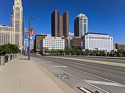
Downtown Columbus is the central business district of Columbus, Ohio. Downtown is centered on the intersection of Broad and High Streets, and encompasses all of the area inside the Inner Belt. Downtown is home to most of the tallest buildings in Columbus.

Columbus, the state capital and Ohio's largest city, has numerous neighborhoods within its city limits. Neighborhood names and boundaries are not officially defined. They may vary or change from time to time due to demographic and economic variables.

<span class="mw-page-title-main">Central High School (Columbus, Ohio)</span> United States historic place

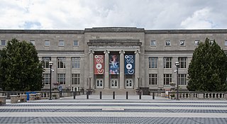
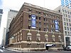
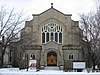
Central High School, also known as High School of Columbus and High School of Commerce, was a four-year secondary school located in Franklinton, Columbus, Ohio. It was a part of Columbus City Schools. On March 7, 1985, the 1924 school building was added to the National Register of Historic Places. It is considered part of the Columbus Civic Center Historic District.

<span class="mw-page-title-main">Geography of Columbus, Ohio</span> Topography, climate and cityscape in the city

The city of Columbus is located in central Ohio at the confluence of the Scioto and Olentangy rivers. The region is dominated by a humid continental climate, characterized by hot, muggy summers and cold, dry winters.

<span class="mw-page-title-main">Woodland Park (Columbus, Ohio)</span> Neighborhood of Columbus in Franklin, Ohio, United States

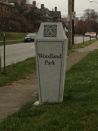
Woodland Park is a residential neighborhood located in the Near East Side of Columbus, Ohio that houses approximately 1,500 residents. The neighborhood was previously home to such figures as artist Emerson Burkhart, cartoonist Billy Ireland, and judge William Brooks. Established in the early 20th century, Woodland Park has grown from its planned neighborhood roots into a neighborhood that contains various faith communities, schools, sources of entertainment and recreation, and borders an extension of the Ohio State University medical center.

<span class="mw-page-title-main">Franklin Park (Columbus, Ohio)</span> Place

Franklin Park is a neighborhood located on the Near East Side of Columbus, Ohio. Both the historic neighborhood and landmark, the Franklin Park Conservatory and Botanical Gardens, are named after the 88-acre park.

Columbus, the capital city of Ohio, was founded on the east bank of the Scioto River in 1812. The city was founded as its capitol, beside the town of Franklinton, since incorporated into Columbus. The city's early history was gradual, as residents dealt with flooding and cholera epidemics, and the city had few direct connections to other cities. This led creation of a feeder canal, and later, freight and passenger railroads. The city became known for its industry and commercial businesses into the 20th century, though it experienced a lull in development in the late 20th century. In the 21st century, Columbus has been increasingly revitalized, led by parks projects, new developments, and efforts to beautify individual neighborhoods.

<span class="mw-page-title-main">Toledo and Ohio Central Railroad Station</span> Historic site

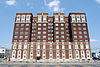
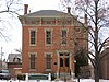
The Toledo and Ohio Central Railroad Station, today named Station 67, is a union meeting space and event hall located in Franklinton, near Downtown Columbus, Ohio. Built by the Toledo and Ohio Central Railroad from 1895 to 1896, it served as a passenger station until 1930. It served as an office and shelter for Volunteers of America from 1931 to 2003, and has been the headquarters of International Association of Fire Fighters Local 67, a firefighters' union, since 2007. The building was placed on the National Register of Historic Places in 1973. During its history, the building has experienced fires and floods, though its relatively few owners have each made repairs and renovations to preserve the building's integrity. The building is the last remaining train station in Columbus.

<span class="mw-page-title-main">Discovery Bridge (Columbus, Ohio)</span> Overpass on the Scioto River

The Discovery Bridge, commonly known as the Broad Street Bridge, is a bridge in Columbus, Ohio, United States, carrying Broad Street over the Scioto River and connecting Downtown Columbus to Franklinton. The bridge was named in reference to Christopher Columbus's "discovery" of the Americas; the bridge includes artistic bronze medallions featuring symbols of the explorer.

<span class="mw-page-title-main">Rich Street Bridge</span> Overpass in Columbus, Ohio

The Rich Street Bridge is a bridge in Columbus, Ohio, United States, spanning the Scioto River and connecting downtown's Rich Street to Franklinton's Town Street. It carries U.S. Route 62 (US 62) and Ohio State Route 3 (SR 3). The bridge was completed in 2012.

<span class="mw-page-title-main">Dorrian Green</span> Park in Columbus, Ohio, U.S.

Dorrian Green is a park by the Franklinton neighborhood of Columbus, Ohio. The park is part of the Scioto Mile network of parks and trails around downtown Columbus. Dorrian Green neighbors COSI, the city's science and children's museum.

<span class="mw-page-title-main">Columbus Civic Center (Ohio)</span> Civic center in downtown Columbus, Ohio

The Columbus Civic Center is a civic center, a collection of government buildings, museums, and open park space in Downtown Columbus, Ohio. The site is located along the Scioto Mile recreation area and historically was directly on the banks of the Scioto River.

<span class="mw-page-title-main">High Street (Columbus, Ohio)</span> North-south street in Columbus, Ohio

High Street is a major thoroughfare in Central Ohio, predominantly in Franklin County and Columbus. It stretches from the northern border of Columbus in Delaware County south to the southern boundary of Franklin County just past Columbus's municipal boundaries. The street is considered one of Columbus's two main roads, along with Broad Street.

<span class="mw-page-title-main">Great Flood of 1913 in Columbus, Ohio</span> 1913 flood in the United States

The Great Flood of 1913 severely affected Columbus, Ohio. The area most affected was Franklinton, also known as the Bottoms, for its low elevation near the Scioto River. Among many infrastructure projects, a 7.2-mile floodwall was built from 1993 to 2004 to protect most of Franklinton from flooding.

<span class="mw-page-title-main">10 E Broad / W Broad</span> Bus line in Columbus, Ohio

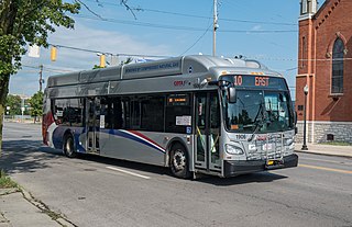
The 10 E Broad / W Broad is a Central Ohio Transit Authority (COTA) bus service in Columbus, Ohio. The line operates on Broad Street, the city's main east-west thoroughfare.

References

  1. Google (July 7, 2020). "Overview map of Broad Street" (Map). Google Maps . Google. Retrieved July 7, 2020.
  2. 1 2 Elliott, Susannah (July 28, 2015). "What is the longest, continuously running street in Columbus?". The Columbus Dispatch. Retrieved May 21, 2020.
  3. 1 2 3 4 5 6 "Broad Street Bungled Yet Again". Columbus Navigator. April 9, 2019.
  4. 1 2 "The Start of Broad and High". The Columbus Dispatch. October 14, 1962. p. 163. Retrieved October 23, 2021.
  5. "Canal connected city to world". ThisWeek Community News.
  6. 1 2 "Broad Street: Street of Dreams". The Columbus Dispatch.
  7. Lentz, Ed (May 22, 2023). "East Broad was the 'Dream Street' for Columbus' movers and shakers by end of 19th century". The Columbus Dispatch. Retrieved June 19, 2023.
  8. Moore, Opha (1930). History of Franklin County Ohio. Topeka-Indianapolis: Historical Publishing Company. p. 127.
  9. Federal Writers' Project employees (1946). The Ohio Guide (3rd ed.). Oxford University Press. p. 246. ISBN   9781603540346 . Retrieved April 27, 2020.
  10. Dispatch, Rick Rouan, The Columbus. "W. Broad St. project to reshape streetscape". The Columbus Dispatch.{{cite web}}: CS1 maint: multiple names: authors list (link)
  11. "10 E Broad/W Broad" (PDF). Central Ohio Transit Authority. Retrieved March 23, 2020.
  12. "How to List a Property". National Register of Historic Places (U.S. National Park Service). November 26, 2019. Retrieved December 22, 2019.
  13. "Eligibility". National Historic Landmarks (U.S. National Park Service). August 29, 2018. Retrieved December 22, 2019.