
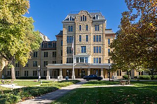
Franklin Park Conservatory and Botanical Gardens is a botanical garden and conservatory located in Columbus, Ohio. It is open daily and an admission fee is charged. Today, it is a horticultural and educational institution showcasing exotic plant collections, special exhibitions, and Dale Chihuly artworks.
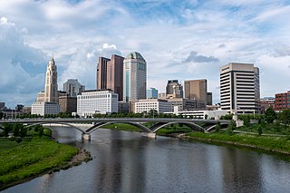
The Columbus, Ohio metropolitan area is a metropolitan area in Central Ohio surrounding the state capital of Columbus. As defined by the U.S. Census Bureau, it includes the counties of Delaware, Fairfield, Franklin, Hocking, Licking, Madison, Morrow, Perry, Pickaway, and Union. At the 2020 census, the MSA had a population of 2,138,926, making it 32nd-most populous in the United States and the second largest in Ohio, behind the Cincinnati metropolitan area. The metro area, also known as Central Ohio or Greater Columbus, is one of the largest and fastest-growing metropolitan areas in the Midwestern United States.
The Near East Side is a neighborhood located near downtown Columbus, Ohio, made up of several neighborhoods: Mount Vernon, King-Lincoln Bronzeville, Eastgate, Franklin Park, Nelson Park, Olde Towne East, and Woodland Park.

Olde Towne East is a neighborhood located in the historical Near East Side of Columbus, Ohio and is one of Columbus' oldest neighborhoods. The area has over 1,000 homes, some as old as the 1830s, and more than 50 architectural styles as a result of its history. These homes were built by many of the famous individuals of Columbus including industrialists, lawyers, judges, teachers, architects, mayors, governors, and legislators, many of whom shaped the city.
Columbus, the state capital and Ohio's largest city, has numerous neighborhoods within its city limits. Neighborhood names and boundaries are not officially defined. They may vary or change from time to time due to demographic and economic variables.
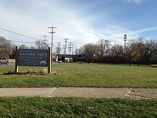
Driving Park is an urban residential area on the Near East Side of Columbus, Ohio just south of Interstate 70. Mainly a middle-class, predominantly African American neighborhood, Driving Park and its surrounding neighborhoods consist of an area of 17,730 residents. Driving Park received its name from its historic past as a large racing complex, first for horses and later for automobiles.
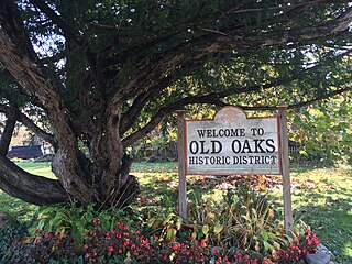
Old Oaks Historic District, or Old Oaks, is a neighborhood just south and east of downtown Columbus, Ohio and is an example of a streetcar suburb in the city.

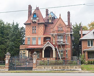
Joseph Warren Yost (1847–1923) was a prominent architect from Ohio whose works included many courthouses and other public buildings. Some of his most productive years were spent as a member of the Yost and Packard partnership with Frank Packard. Later in his career he joined Albert D'Oench at the New York City based firm D'Oench & Yost. A number of his works are listed for their architecture in the U.S. National Register of Historic Places (NRHP).

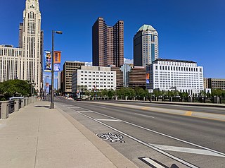
The city of Columbus is located in central Ohio at the confluence of the Scioto and Olentangy rivers. The region is dominated by a humid continental climate, characterized by hot, muggy summers and cold, dry winters.
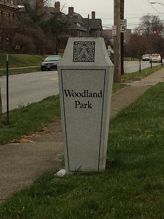
Woodland Park is a residential neighborhood located in the Near East Side of Columbus, Ohio that houses approximately 1,500 residents. The neighborhood was previously home to such figures as artist Emerson Burkhart, cartoonist Billy Ireland, and judge William Brooks. Established in the early 20th century, Woodland Park has grown from its planned neighborhood roots into a modest neighborhood that contains various faith communities, schools, sources of entertainment and recreation, and borders an extension of the Ohio State University medical center.

Franklin Park is a neighborhood located on the Near East Side of Columbus, Ohio. Both the historic neighborhood and landmark, the Franklin Park Conservatory and Botanical Gardens, are named after the 88-acre park.
Columbus Public Health is the health department of Columbus, Ohio. The department is accredited by the Public Health Accreditation Board. The department dates to 1833, when the city's mayor appointed five citizens to help with its cholera outbreak. It became a permanent body to activate whenever health emergencies arose.

The Hamilton Park Historic District is a historic district in the Near East Side of Columbus, Ohio. The site was listed on the National Register of Historic Places in 1983 and the Columbus Register of Historic Properties in 1987. It is one of few remaining examples of an 1880-1930 upper middle class neighborhood in Columbus. The district also contains an unusual street layout, with three parallel streets creating two islands. It is thought to have been one larger island originally, as can be seen on Jefferson Avenue.
Broad Street is a major thoroughfare in Central Ohio, predominantly in Franklin County and Columbus. It stretches east from West Jefferson at Little Darby Creek to Pataskala. The street is considered one of Columbus's two main roads, along with High Street.

The 18th & E. Broad Historic District is a historic district on Broad Street in the Near East Side of Columbus, Ohio. The district was added to the Columbus Register of Historic Properties in 1988. Its properties were added to the E. Broad St. Multiple Resources Area on the National Register of Historic Places in 1986.

The 21st & E. Broad Historic District is a historic district on Broad Street in the Near East Side of Columbus, Ohio. The district was added to the Columbus Register of Historic Properties in 1988. Its properties were added to the E. Broad St. Multiple Resources Area on the National Register of Historic Places in 1986.

The Avery Pontiac Building is a historic building in Columbus, Ohio. It is located in Columbus's Near East Side, roughly between the Franklin Park and Olde Towne East neighborhoods. The building was added to the Columbus Near East Side District in 1978. It was individually listed on the Columbus Register of Historic Properties in 1984.
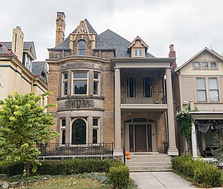
The Charles Frederick Myers house is a historic private residence in the Franklin Park neighborhood of Columbus, Ohio. The house was built in 1896 in an eclectic style. It was added to the Columbus Near East Side District in 1978, and the Bryden Road District in 1990.
The Joseph Warren Yost House is a historic house in Columbus, Ohio. It was added to the Columbus Near East Side District in 1978, and the Bryden Road District in 1990.

The Fair Avenue Elementary School is a historic school building in the Franklin Park neighborhood of Columbus, Ohio. The building contributes to the Columbus Near East Side District, on the National Register of Historic Places. It was built in the Richardsonian Romanesque style in 1890, having been designed by prolific Columbus architect Frank Packard. The building, originally housing a school as part of the Columbus Public School District, currently houses one of three campuses of the A+ Arts Academy.


