Broadway Tunnel (San Francisco)

Last updated

Broadway Tunnel
SF Broadway Tunnel.jpg
Western portal, from inside the north tunnel, facing west
Overview
Location San Francisco, California
Coordinates 37°47′49″N122°24′54″W / 37.796812°N 122.414893°W / 37.796812; -122.414893
Route Broadway
StartBetween Powell and Mason Streets
EndBetween Hyde and Larkin Streets
Operation
Work begunMay 1, 1950
OpenedDecember 21, 1952;71 years ago (1952-12-21)
OwnerCity of San Francisco
OperatorCity of San Francisco
TrafficAutomotive and pedestrian
Technical
Length1,616 ft (493 m)
No. of lanes 4
Operating speed40 mph (64 km/h)
Tunnel clearance 13.5 ft (4.1 m)

The Broadway Tunnel (officially the Robert C. Levy Tunnel) is a roadway tunnel in San Francisco, California. The tunnel opened in 1952, and serves as a high-capacity conduit for traffic between Chinatown and North Beach to the east and Russian Hill and Van Ness Avenue to the west. In a proposal of the city's 1948 Trafficways Plan, the tunnel was to serve as a link between the Embarcadero Freeway and the Central Freeway. [1]

Contents

History

Broadway Tunnel (7559399108).jpg
Western portal, from the Hyde Street overpass
20085 Broadway East (39788350950).jpg
Eastern portal

Early plans

Abner Doble (grandfather of the namesake who would go on to build steam-powered cars) and his associates in the Folsom St. and Fort Point Railroad and Tunnel Co. were granted "the right to construct a tunnel through Russian Hill, on the line of Broadway, from Mason to Hyde or Larkin" by the California State Assembly on April 22, 1863. [2] :414 [3] [4]

Fifty years later, Bion J. Arnold submitted a report to the City of San Francisco in March 1913, calling for a tunnel on Broadway to supplement the Stockton Street Tunnel, which was already under construction. [2] The general route of a tunnel for Broadway was described in April 1913, extending from Mason to Larkin. [5] A landowner protested against the proposed tunnel, calling it "absolutely as unnecessary as a bridge to the moon". [6] Also in 1913, a railway tunnel was proposed for Broadway as part of an extension for the Municipal Railway to carry passengers to and from the Panama-Pacific Exposition. [7] Arnold's proposal called for a combined rail and road tunnel with a single arch for Broadway through Russian Hill, 2,338 feet (713 m) long and 60 feet (18 m) wide, carrying two tracks each 11 feet (3.4 m) wide; three lanes of traffic 24 feet (7.3 m) wide in total; and two sidewalks each 7 feet (2.1 m) wide. [2] :220,222–224

Plans were elaborated in brief by City Engineer M.M. O'Shaughnessy as one of ten potential tunnel projects in San Francisco at the October 1917 meeting for the San Francisco Association of the members of the American Society of Civil Engineers. O'Shaughnessy proposed a 2,300-foot-long (700 m) bore, but the article reporting the meeting described it as merely "investigated and not likely to be soon built". [8]

Invisible Square.svg
Mapscaleline.svg
300m
330yds
Red pog.svg
Robert C Levy (Broadway) Tunnel in San Francisco
1
Western portal
2
Eastern portal

Construction

In 1948, voters in the City of San Francisco passed a $5 million bond measure (equivalent to $48.9 million in 2023 [9] ) to fund the construction of the Broadway Tunnel. [10] Site preparations, including the move of an apartment building from 1453 Mason to Vallejo Street, [11] were underway by October 1949, and the construction contract was anticipated to be bid in January 1950. [12] In February, Morrison-Knudsen was awarded the contract after submitting the low bid of $5,243,355 (equivalent to $50.8 million in 2023 [9] ) [13] and construction began in May 1950. [14] The final cost was some $7.3 million (equivalent to $64.9 million in 2023 [9] ). [15]

Completion was originally projected for May 1952, but unanticipated loose rock meant that shoring was required. [16] The tunnel opened to traffic on December 21, 1952. [15] Mayor Elmer Robinson cut a ceremonial ribbon to mark the occasion. [14]

Dedication and later years

Dedication plaque 20117 Levy Plaque (41556170642).jpg
Dedication plaque

The Broadway Tunnel was named in honor of Robert C. Levy (1921–1985) in January 1986. Levy was the city engineer and superintendent of building inspection for the City and County of San Francisco. A plaque outside the tunnel reads, "He devoted his life to high standards of professionalism in engineering and to the City which he loved."

Design

The east portal is just east of the Mason Street overpass. The west portal is just east of the Hyde Street overpass. Combined with these two overpasses, the tunnel provides for uninterrupted traffic flow along Broadway for a stretch of six blocks, between Powell on the east and Larkin on the west. There are two bores, each carrying two lanes of one-way traffic. The northern tunnel carries westbound traffic, and the southern tunnel carries eastbound traffic. Each tunnel is 1,616 feet (493 m) long. [15]

Eastbound tunnel, facing east. The large overhang is above. 0190 Abrupt Overhang (40704747055).jpg
Eastbound tunnel, facing east. The large overhang is above.

The vertical clearance throughout much of the tunnel is nearly 20 feet (6.1 m), but there is an overhanging concrete slab at the eastern end, which reduces vertical clearance to 13 feet 6 inches (4.11 m). [17]

There are narrow sidewalks on the outboard side of each tunnel (e.g., the north side of the westbound tunnel). Bicyclists tend to use the sidewalk, but signal lights triggered by an inductive loop were installed in 2011 to alert motorists to the presence of bicycles in the tunnel. [18]

Westbound tunnel, facing west. BroadwayTunnelSFCA.png
Westbound tunnel, facing west.
The Chinatown Public Health Center on top of the tunnel's eastern end (seen from the West across Mason Street) Chinatown Public Health Center (2020) 01.jpg
The Chinatown Public Health Center on top of the tunnel's eastern end (seen from the West across Mason Street)

Public art and architecture

A stylized dragon relief sculpture by Patti Bowler, rendered in bronze, has been mounted above the eastern portal of the tunnel since 1969. [19] [20] The building atop the eastern portal is the Chinatown Public Health Center (Chinese :華埠公共衛生局), a public health clinic operated by the San Francisco Department of Public Health. [21] It was built in the 1970s and remodeled in 2010. [22]

Reverse graffiti by Moose in 2008 Broadway tunnel reverse graffiti (2837240680).jpg
Reverse graffiti by Moose in 2008

In 2008, the artist Moose, sponsored by a company, executed a 140-foot-long (43 m) mural by cleaning dirt from the side of the approach to the western portal of the tunnel using pressure washing and cardboard stencils, a technique known as reverse graffiti. [23]

The Broadway Tunnel has been used as a filming location for several motion pictures, including: [24]

Related Research Articles

<span class="mw-page-title-main">San Francisco Municipal Railway</span> Public transport agency in San Francisco, California, USA

The San Francisco Municipal Railway ( MEW-nee; SF Muni or Muni), is the primary public transit system within San Francisco, California. It operates a system of bus routes, the Muni Metro light rail system, three historic cable car lines, and two historic streetcar lines. Previously an independent agency, the San Francisco Municipal Railway merged with two other agencies in 1999 to become the San Francisco Municipal Transportation Agency (SFMTA). In 2018, Muni served 46.7 square miles (121 km2) with an operating budget of about $1.2 billion. Muni is the seventh-highest-ridership transit system in the United States, with 142,168,200 rides in 2023, and the second-highest in California after the Los Angeles County Metropolitan Transportation Authority.

<span class="mw-page-title-main">Richmond–San Rafael Bridge</span> Bridge crossing the San Francisco Bay

The Richmond–San Rafael Bridge is the northernmost of the east–west crossings of California's San Francisco Bay, carrying Interstate 580 from Richmond on the east to San Rafael on the west. It opened in 1956, replacing ferry service by the Richmond–San Rafael Ferry Company, and was officially renamed in 1981 to honor California State Senator John F. McCarthy, who championed the bridge's creation.

<span class="mw-page-title-main">Muni Metro</span> Light rail system in San Francisco

Muni Metro is a semi-metro system serving San Francisco, California, United States. Operated by the San Francisco Municipal Railway (Muni), a part of the San Francisco Municipal Transportation Agency (SFMTA), Muni Metro served an average of 68,700 passengers per weekday in the first quarter of 2023, making it the seventh-busiest light rail system in the United States.

<span class="mw-page-title-main">Sunset Tunnel</span> Streetcar tunnel in San Francisco, California, U.S.

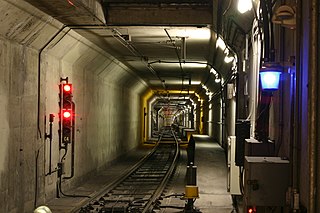
The Sunset Tunnel, originally known as the Duboce Tunnel, is a 4,232 ft (1,290 m)-long light rail/streetcar tunnel in San Francisco, California. The tunnel runs under the steep hill adjacent to Buena Vista Park and is used exclusively by the N Judah Muni Metro line.

<span class="mw-page-title-main">Third Street Light Rail Project</span> San Francisco Muni tram line

The Third Street Light Rail Project was the construction project that expanded the Muni Metro system in San Francisco, California, linking downtown San Francisco to the historically underserved southeastern neighborhoods of Bayview-Hunters Point and Visitacion Valley along the eastern side of the city. Construction was finished in late 2006, non-revenue weekend service began on January 13, 2007, and full service began on April 7, 2007. The new service, as the T Third Street Metro line, replaced the 15 Third bus line, which ran south from the Caltrain Depot at 4th and King streets, along Third Street and Bayshore Boulevard to the southeastern neighborhoods.

<span class="mw-page-title-main">Central Subway (San Francisco)</span> Underground light rail line

The Central Subway is a Muni Metro light rail tunnel in San Francisco, California, United States. It runs between Chinatown station in Chinatown and a portal in South of Market (SoMa), with intermediate stops at Union Square/Market Street station in Union Square and Yerba Buena/Moscone station in SoMa. A surface portion runs through SoMa to connect to the previously existing T Third Street line at 4th and King station.

<span class="mw-page-title-main">Twin Peaks Tunnel</span> Light rail tunnel in San Francisco, California

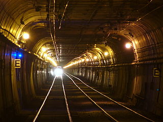
The Twin Peaks Tunnel is a 2.27-mile-long (3.65 km) light rail/streetcar tunnel in San Francisco, California. The tunnel runs under Twin Peaks and is used by the K Ingleside, M Ocean View and S Shuttle lines of the Muni Metro system.

<span class="mw-page-title-main">Market Street subway</span> BART-Muni Metro main line, San Francisco

The Market Street subway is a two-level subway tunnel that carries Muni Metro and BART trains under Market Street in San Francisco, California. It runs under the length of Market Street between Embarcadero station and Castro station. The upper level is used by Muni Metro lines and the lower level is used by BART lines. BART does not run through the whole subway; it turns south and runs under Mission Street southwest of Civic Center/UN Plaza station. The northeastern end of the BART level is connected to the Transbay Tube. On the Muni Metro level, the southwestern end of the Market Street subway connects to the much-older Twin Peaks Tunnel, and the northeastern end connects to surface tracks along the Embarcadero.

<span class="mw-page-title-main">California State Route 480</span> Former highway in California

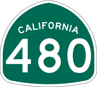
State Route 480 was a state highway in San Francisco, California, United States, consisting of the elevated double-decker Embarcadero Freeway, the partly elevated Doyle Drive approach to the Golden Gate Bridge and the proposed and unbuilt section in between. The unbuilt section from Doyle Drive to Van Ness Avenue was to have been called the Golden Gate Freeway and the Embarcadero Freeway as originally planned would have extended from Van Ness along the north side of Bay Street and then along the Embarcadero to the San Francisco-Oakland Bay Bridge.

<span class="mw-page-title-main">T Third Street</span> San Francisco light rail line

The T Third Street is a Muni Metro light rail line in San Francisco, California. It runs along the east side of San Francisco from Sunnydale to Chinatown, traveling in the median of Third Street for most of its length before entering the Central Subway as it approaches downtown. The line serves 22 stations, all of which are accessible. Most of the surface portion of the line runs in dedicated median lanes, though two portions operate in mixed traffic.

<span class="mw-page-title-main">Ferries of San Francisco Bay</span>

San Francisco Bay in California has been served by ferries of all types for over 150 years. John Reed established a sailboat ferry service in 1826. Although the construction of the Golden Gate Bridge and the San Francisco–Oakland Bay Bridge led to the decline in the importance of most ferries, some are still in use today for both commuters and tourists.

<span class="mw-page-title-main">Michael O'Shaughnessy</span>

Michael Maurice O'Shaughnessy was an Irish civil engineer who became city engineer for the city of San Francisco during the early twentieth century and developed both the San Francisco Municipal Railway (Muni) and the Hetch Hetchy water system.

<span class="mw-page-title-main">Stockton Street (San Francisco)</span> Street in San Francisco, California, US

Stockton Street is a north-south street in San Francisco. It begins at Market Street passing Union Square, a major shopping district in the city. It then runs underground for about two and a half blocks in the Stockton Street Tunnel, passes through Chinatown and North Beach, and ends at Beach Street near the Pier 39 shopping center and tourist attraction.

<span class="mw-page-title-main">MacArthur Tunnel</span> Road tunnel in San Francisco

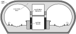
The MacArthur Tunnel, formally known as the General Douglas MacArthur Tunnel, is a highway tunnel in San Francisco, California.

<span class="mw-page-title-main">Stockton Street Tunnel</span> Road tunnel in San Francisco

The Stockton Street Tunnel is a tunnel in San Francisco, California, which carries its namesake street underneath a section of Nob Hill near Chinatown for about three blocks. It was opened in 1914. The south portal is located just shy of Bush Street, which is about two blocks to the north of Union Square. The north portal is located just to the south of the Sacramento Street intersection.

<span class="mw-page-title-main">Chinatown station (Muni Metro)</span> Subway station in San Francisco, California, US

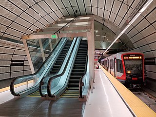
Chinatown station is an underground Muni Metro light rail station, located under Stockton Street at Washington Street in the Chinatown neighborhood of San Francisco, California. It opened on November 19, 2022, as part of the Central Subway project. The station's official name honors Rose Pak, a political activist in the Chinatown community who helped secure support and funding for the station and the extension of the T Third Street line.

<span class="mw-page-title-main">Union Square/Market Street station</span> Underground light rail station in San Francisco, California, US

Union Square/Market Street station is an underground Muni Metro light rail station located adjacent to the southeast corner of Union Square in San Francisco, California. It opened on November 19, 2022, as part of the Central Subway project. It is the penultimate northbound station on the T Third Street, since T service moved to the Central Subway on January 7, 2023.

<span class="mw-page-title-main">Fillmore Street Tunnel</span> Proposed San Francisco streetcar tunnel

The Fillmore Street Tunnel was a proposed double-bore tunnel approximately 34 mile (1.2 km) long in San Francisco, California which would have carried Fillmore Street and a new streetcar line underneath Pacific Heights and Russian Hill. The proposed tunnel would have connected the Western Addition and Fillmore Districts, near the south portal at Sutter Street, with Marina and Cow Hollow, near the north portal at Filbert Street. One tunnel would have been reserved for railroad and pedestrian traffic, while the parallel tunnel would have been for vehicles. The tunnel was planned, along with the contemporary Twin Peaks and Stockton Street Tunnels, to serve the traffic that was anticipated from the 1914–15 Panama–Pacific International Exposition.

References

  1. Wolff, Jane (August 15, 2021). Bay Lexicon . Montreal: McGill-Queen’s University Press. p. 127. doi:10.1515/9780228007913. ISBN   9780228007913. Proposed in a 1948 transportation plan to link the Embarcadero and Central Freeways, the Broadway Tunnel is a not-so-distant cousin of the city's constructed waterfront.
  2. 1 2 3 Arnold, Bion J. (March 1913). "10. Tunnels into Harbor View". Report on the Improvement and Development of the Transportation Facilities of San Francisco (Report). Retrieved April 17, 2018.
  3. "Appendix: Railroad Franchises". San Francisco Municipal Reports for the Fiscal Year 1879-80 Ending June 30, 1880 (Report). San Francisco Board of Supervisors. p. 914. Retrieved April 17, 2018.
  4. California State Assembly. "An Act to provide for the construction of a Street Railroad and Tunnel through Russian Hill, in the City and County of San Francisco". Fourteenth Session of the Legislature. Statutes of California. State of California. Ch. 293 p. 392. The right is hereby given to Abner Doble, I.T. Pennel, Joseph M. Wood, I.W. Cudworth, to them and their associates and assigns, to construct a tunnel in the City and County of San Francisco, through Russian Hill, on the line of Broadway street, from Mason street to Hyde or Larkin street, with the exclusive use of said tunnel, and the right to charge tolls upon animals and vehicles which may pass through the same. Said tunnel shall not be less than twenty feet in width, by sixteen feet in height, in the centre chord thereof; the entrances, shafts, slopes, and open cuts, shall be protected with suitable railings, walls, etc., to prevent accidents; [...]
  5. "Tunnel Committee Makes Progress Report". Municipal Record. Vol. 6, no. 17. San Francisco Board of Supervisors. April 24, 1913. p. 78. Retrieved April 16, 2018.
  6. "Protests Against Proposed Broadway Tunnel". Municipal Record. Vol. 6, no. 10. San Francisco Board of Supervisors. March 6, 1913. p. 130. Retrieved April 16, 2018.
  7. O'Shaughnessy, M. M. (April 5, 1913). Report on Extension of Municipal Railways to Provide Transportation for the Panama-Pacific Exposition (Report). San Francisco Board of Supervisors. Retrieved April 16, 2018.
  8. "City Engineer Describes City Tunnels". Municipal Record. Vol. 10, no. 50. San Francisco Board of Supervisors. December 13, 1917. pp. 409–410. Retrieved April 16, 2018.
  9. 1 2 3 Johnston, Louis; Williamson, Samuel H. (2023). "What Was the U.S. GDP Then?". MeasuringWorth. Retrieved November 30, 2023. United States Gross Domestic Product deflator figures follow the Measuring Worth series.
  10. Wallace, Kevin (March 27, 1949). "The City's Tunnels: When S.F. Can't Go Over, It Goes Under Its Hills". San Francisco Chronicle. Archived from the original on June 15, 2008. Retrieved September 1, 2010.
  11. Donovan, Diane C.; Montgomery, Steve (2015). San Francisco Relocated. Arcadia Publishing. p. 78. ISBN   978-1-4671-3371-5 . Retrieved April 17, 2018.
  12. "Broadway Tunnel Brings Sausalito Closer to S.F." Sausalito News. October 27, 1949. Retrieved April 16, 2018.
  13. "Low Bidder Named for Bay City Tunnel Job". San Bernardino Sun. Associated Press. February 3, 1950. Retrieved April 16, 2018.
  14. 1 2 "Broadway Tunnel Opened To Traffic". Santa Cruz Sentinel. AP. December 22, 1952. Retrieved April 16, 2018.
  15. 1 2 3 "Broadway Tunnel Opens Sunday; Will Cut Travel Time from Sausalito to S.F." Sausalito News. December 18, 1952. Retrieved April 16, 2018.
  16. "S.F. Tunnel Job Faces New Delay". Sausalito News. April 10, 1952. Retrieved April 16, 2018.
  17. Egelko, Bob (August 19, 2006). "San Francisco: Tunnel death suit rejected". San Francisco Chronicle. Retrieved April 16, 2018.
  18. Bialick, Aaron (June 3, 2011). "SFMTA Installs Bike and Ped Lights on the Broadway Tunnel and Tenderloin". Streetsblog SF. Retrieved April 16, 2018.
  19. Cindy (March 28, 2012). "Chinatown – Broadway Tunnel". Art and Architecture SF. Retrieved April 16, 2018.
  20. "Dragon Relief, (sculpture)". Smithsonian American Art Museum. 1969. Retrieved April 16, 2018.
  21. "Chinatown Public Health Center". San Francisco Health Network. Retrieved April 16, 2018.
  22. "Chinatown Health Center". San Francisco Department of Public Works. Retrieved April 16, 2018.
  23. Colom, Francisco. "Reverse Graffiti Project in San Francisco". More Than Green. Retrieved April 16, 2018.
  24. 1 2 3 4 "Film Locations in San Francisco" (PDF). City of San Francisco. April 17, 2018. Retrieved April 17, 2018.
  25. Wethern, George; Colnett, Vincent (1978). A Wayward Angel: The Full Story of the Hells Angels. Richard Marek Publishers. ISBN   1-59228-385-3 . Retrieved April 16, 2018.
  26. "Broadway Tunnel to close for film car chase Sunday". San Francisco Examiner. October 14, 2006. Retrieved April 16, 2018.
  27. "What Dreams May Come". Film in America. Retrieved April 16, 2018.