State Route 1 (SR 1) is a major north–south state highway that runs along most of the Pacific coastline of the U.S. state of California. At 656 miles (1,056 km), it is the longest state route in California, and the second-longest in the US after Montana Highway 200. SR 1 has several portions designated as either Pacific Coast Highway (PCH), Cabrillo Highway, Shoreline Highway, or Coast Highway. Its southern terminus is at Interstate 5 (I-5) near Dana Point in Orange County and its northern terminus is at U.S. Route 101 (US 101) near Leggett in Mendocino County. SR 1 also at times runs concurrently with US 101, most notably through a 54-mile (87 km) stretch in Ventura and Santa Barbara counties, and across the Golden Gate Bridge.

San Mateo County, officially the County of San Mateo, is a county located in the U.S. state of California. As of the 2020 census, the population was 764,442. Redwood City is the county seat, and the third most populated city following Daly City and San Mateo. San Mateo County is included in the San Francisco–Oakland–Berkeley, CA MSA, Silicon Valley, and is part of the San Francisco Bay Area, the nine counties bordering San Francisco Bay. It covers most of the San Francisco Peninsula. San Francisco International Airport is located in the northeastern area of the county and is approximately 7 miles south of the city and county limits of San Francisco, even though the airport itself is assigned a San Francisco postal address. The county's built-up areas are mostly suburban, and are home to several corporate campuses.

Montara is a census-designated place (CDP) in San Mateo County, California, United States. The population was 2,833 at the 2020 census. Nearby communities include Moss Beach and Princeton-by-the-Sea.

The Caldecott Tunnel is an east–west highway tunnel through the Berkeley Hills between Oakland and Orinda, California. Its four bores carry California State Route 24. Named after Thomas E. Caldecott, former mayor of Berkeley, it opened in 1937 as a two-bore tunnel. The third bore opened in 1964 and the fourth bore in 2013. Currently, the two oldest bores carry eastbound traffic and the two newest bores carry westbound traffic.

Devil's Slide is a coastal promontory in California, United States. It lies on the San Mateo County coast between Pacifica and Montara. Its name comes from the rocky edges prone to accident.

State Route 4 is a state highway in the U.S. state of California, routed from Interstate 80 in the San Francisco Bay Area to State Route 89 in the Sierra Nevada. It roughly parallels the Sacramento-San Joaquin River Delta, a popular area for boating and fishing, with a number of accesses to marinas and other attractions. After crossing the Central Valley, the highway ascends up the Sierra foothills. It passes through Ebbetts Pass and contains the Ebbetts Pass Scenic Byway, a National Scenic Byway.

U.S. Route 101 (US 101) is a major north–south United States Numbered Highway, stretching from Los Angeles, California, to Tumwater, Washington. The California portion of US 101 is one of the last remaining and longest U.S. Routes still active in the state, and the longest highway of any kind in California. US 101 was also one of the original national routes established in 1926. Significant portions of US 101 between the Los Angeles area and the San Francisco Bay Area follow El Camino Real, the commemorative route connecting the former Alta California's 21 missions.
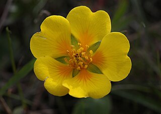
Potentilla hickmanii is an endangered perennial herb of the rose family. This rare plant species is found in a narrowly restricted range in two locations in coastal northern California, in Monterey County, and in very small colonies in San Mateo County. This small wildflower, endemic to western slopes of the outer coastal range along the Pacific Ocean coast, produces bright yellow blossoms through spring and summer.
Martini Creek is a coastal stream whose watershed lies entirely within San Mateo County, California, United States on the western exposures of the Montara mountain block, discharging to the Pacific Ocean. It flows about 2 miles (3 km) from its source on Montara Mountain to its mouth in Montara State Beach. This stream has a drainage basin composed of open space and agricultural lands. Some of the basin has moderate to steep slopes and much of the basin habitat is northern coastal scrub, and in places almost of a pygmy forest nature.

Montara State Beach is a beach located in the coastal region of the U.S. state of California, eight miles north of Half Moon Bay on State Route 1. It is operated by the California State Department of Parks and Recreation under the San Mateo Coast Sector Office. It is one of the cleanest beaches in the state and is known for surfing and fishing.

Pedro Mountain Road describes a series of historical road crossings of Pedro Mountain, a promontory ridge located between Montara Mountain and the coastal cliffs of Devil's Slide in San Mateo County, California. This Pedro Mountain headland blocks the easy passage of coastal travelers between the Pedro Valley in Pacifica, California and Montara, California. The most prominent of these Pedro Mountain roads was Coastside Boulevard, the 1914 to 1937 coastal highway 57, which remains in use today as part of the trail network of McNee Ranch State Park.

Montara Mountain, positioned between the unincorporated community of Montara, California, to the southwest and the city of Pacifica, California, to the north, forms the northern spur of the Santa Cruz Mountains, a narrow mountain range running the length of the San Francisco Peninsula that separates San Francisco Bay from the Pacific Ocean. Its highest point rises to 1,898 feet (579 m) above sea level. Montara and Pacifica are connected by the Tom Lantos Tunnels, which run through the Mountain.
Purissima is a ghost town in southwestern San Mateo County, California, United States, near the junction of State Route 1 and Verde Road. Purísima means "purest" in Spanish and is most commonly used in Spanish to refer to La Purísima Concepción of the Virgin Mary. Purissima is the name of the town used as the setting for Ross Macdonald's 1958 crime fiction novel 'The Doomsters'.
The Waldo Grade is a highway grade between the Golden Gate Bridge and Marin City along U.S. Route 101 and State Route 1. It is defined as the stretch of roadway between the Spencer Offramp and Marin City, within the city of Sausalito. This grade is traversed by a full freeway multi-lane highway facility. This portion of US 101/SR 1 is an important link in surface transportation connecting the city of San Francisco to Marin County and the North Bay. Nearby locations to the Waldo Grade include: the city of Sausalito, the U.S. Army Corps of Engineers Bay Model, The Marine Mammal Center and the Golden Gate National Recreation Area. It, and nearby Waldo Point along Richardson Bay between Sausalito and Mill Valley, is named after 1850s California politician William Waldo.

The San Mateo–Hayward Bridge is a bridge crossing the American state of California's San Francisco Bay, linking the San Francisco Peninsula with the East Bay. The bridge's western end is in Foster City, a suburb on the eastern edge of San Mateo. The eastern end of the bridge is in Hayward. It is the longest fixed-link bridge in California and the 25th longest in the world by length. The bridge is owned by the state of California, and is maintained by California Department of Transportation (Caltrans), the state highway agency. Further oversight is provided by the Bay Area Toll Authority (BATA).
The Downtown Rail Extension (DTX) is a planned second phase of the San Francisco Transbay Transit Center (TTC). When complete, it will extend the Caltrain Peninsula Corridor commuter rail line from its current northern terminus at 4th and King via a 1.3 mi (2.1 km) tunnel. The new terminus will be near the Financial District and will provide intermodal connections to BART, Muni, Transbay AC Transit buses, and long-distance buses. In addition, the California High Speed Rail Authority (CHSRA) plans to use DTX and the Caltrain-owned Peninsula Corridor for service on the CHSRA San Francisco–San Jose segment. Because DTX uses a long tunnel, current diesel locomotives are not suitable and the Caltrain Modernization Project (CalMod), which includes electrification of the line and acquisition of electrified rolling stock, is a prerequisite.

The Doran Memorial Bridge is the twin pair of steel girder bridges that carry eight lanes of road traffic on Interstate 280 over San Mateo Creek near Hillsborough, California in San Mateo County.
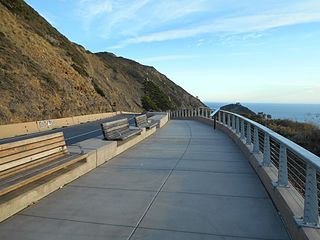
The Devil's Slide Trail is a hiking trail between Pacifica, California and Montara, California in the San Francisco Bay Area. The trail is a segment in the California Coastal Trail, which stretches from Oregon to Mexico.