Broomehill, Western Australia

Last updated

Broomehill
Western Australia
Henry Jones Building, Broomehill, 2018 (01).jpg
The Henry Jones Building, Broomehill, 2018
Australia Western Australia location map.svg
Red pog.svg
Broomehill
Broomehill, Western Australia
Coordinates 33°50′42″S117°38′02″E / 33.84500°S 117.63389°E / -33.84500; 117.63389
Population211 (SAL 2021) [1] [2]
Established1890
Postcode(s) 6318
Elevation332 m (1,089 ft)
Area8.3 km2 (3.2 sq mi)
Location
LGA(s) Shire of Broomehill-Tambellup
State electorate(s) Roe
Federal division(s) O'Connor
Broomehill Post Office building 2018 Broomehill WA post office.jpg
Broomehill Post Office building 2018
Sheridan's memorial garden 2018 Sheridans memorial gardens Broomehill WA.jpg
Sheridan's memorial garden 2018
CBH Group train at Broomehill Watco CBH 1 and 2 Broomehill.jpg
CBH Group train at Broomehill

Broomehill is a town on the Great Southern Highway between Katanning and Albany, in the Great Southern region of Western Australia. Its local government area is the Shire of Broomehill-Tambellup.

Contents

History

The town of Broomehill (originally Broome Hill) owes its creation to the Great Southern Railway, which was completed in 1889. The railway runs from Beverley to Albany. Broomehill is named after Sir Frederick Napier Broome (1842–1896) who was then the Governor of Western Australia.

Gold bearing quartz was discovered by the station master around Broomehill in 1889. [3]

In the same year Patrick Garrity purchased two lots facing Jasper Street and built a galvanised iron hotel. By 1905 the hotel had been rebuilt in brick with more extensions added in 1908. Known as the Broomehill Hotel and later as the Imperial Hotel, the two storey tuck pointed building is now heritage listed. [4]

The townsite was gazetted by the Western Australian Land Company in 1890, which was recognised by the state government in 1897. [5] A group of settlers from the now extinct town of Eticup moved to the present site of Broomehill to help establish a township after the construction of the railway was completed. These settlers included the Withams, the Walshes, and the Curnows. These three families worked hard to establish the early structures. A Victorian named Hamilton acquired 1,300 acres (526 ha) of land around the townsite in 1890; T. W. Powell also acquired 1,000 acres (405 ha) near the town from the Western Australian Land Company. [6]

A branch of the Commercial Bank of Australia was opened in the town-site in 1891. [7]

In 1892, a police station and post office were also established. [8] The Imperial Hotel was operating in the town by late 1892. [9]

The Broomehill Agricultural Hall was opened by T. Norris, a settler of the area, in 1898. [10] The population of the town was 72 (37 males and 35 females) in 1898. [11]

A local Progress association was formed in 1905 with C.J. Darcy taking the position of chairman. [12]

Broomehill Football Club had been established in or before 1907, playing games against surrounding towns such as Katanning. [13]

A cooperative was discussed in 1920 with insufficient capital being raised, [14] in 1921 the cooperative commenced operations after having taken over the premises of Messrs E. Garrity and Company. [15] The official spelling of Broomehill was changed from two words to one in 1959. [8]

Economy

The main industry in town is wheat farming with the town being a Cooperative Bulk Handling receival site. [16] There is also some sheep farming, while more recently farmers have diversified into viticulture and aquaculture (in the form of barramundi farming). [17] [18]

Features

The Holland Track, a well known walking and 4WD track, begins in Broomehill and ends in Coolgardie. [19] The 700 kilometres (435 mi) track was established in 1893 by the pioneer John Holland through the bush via Newdegate to the goldfields at Coolgardie. [20]

Related Research Articles

<span class="mw-page-title-main">Katanning, Western Australia</span> Town in Western Australia

Katanning is a town located 277 kilometres (172 mi) south-east of Perth, Western Australia on the Great Southern Highway. At the 2016 census, Katanning had a population of 3,687.

<span class="mw-page-title-main">Great Southern (Western Australia)</span> Region of Western Australia

The Great Southern region is one of the nine regions of Western Australia, as defined by the Regional Development Commissions Act 1993, for the purposes of economic development. It is a section of the larger South coast of Western Australia and neighbouring agricultural regions.

<span class="mw-page-title-main">Wagin, Western Australia</span> Town in the Wheatbelt region of Western Australia

Wagin is a town and shire in the Wheatbelt region of Western Australia, approximately 225 km (139.81 mi) south-east of Perth on the Great Southern Highway between Narrogin and Katanning. It is also on State Route 107. The main industries are wheat and sheep farming.

<span class="mw-page-title-main">Albany Highway</span> Highway in Western Australia

Albany Highway links Western Australia's capital city Perth with its oldest settlement, Albany, on the state's south coast. The 405-kilometre-long (252 mi) highway travels through the southern Wheatbelt and Great Southern regions, and is designated State Route 30 for most of its length. Outside of Perth the highway is predominately a sealed, single carriageway with regular overtaking lanes in some undulating areas. Albany Highway commences at The Causeway, a river crossing that connects to Perth's central business district. The highway heads south-east through Perth's metropolitan region, bypassed in part by Shepperton Road and Kenwick Link, and continues south-eastwards through to Albany. It intersects several major roads in Perth, including the Leach, Tonkin, Brookton, and South Western highways. The rural section of Albany Highway connects to important regional roads at the few towns and roadhouses along the route, including Coalfields Highway at Arthur River, Great Southern Highway at Cranbrook, and Muirs Highway at Mount Barker.

<span class="mw-page-title-main">Great Southern Highway</span> Highway in Western Australia

Great Southern Highway is a highway in the southern Wheatbelt region of Western Australia, starting from Great Eastern Highway at The Lakes, 50 km (31 mi) from Perth, and ending at Albany Highway near Cranbrook. It is the primary thoroughfare for this part of Western Australia and runs parallel with the Perth-Albany railway for its entire length. It is signed as State Route 120 from York to Cranbrook, and was first named in 1949, although it was built well before that time.

<span class="mw-page-title-main">Division of O'Connor</span> Australian federal electoral division

The Division of O'Connor is an Australian electoral division in the state of Western Australia. It is one of Western Australia's three rural seats, and one of the largest electoral constituencies in the world.

<span class="mw-page-title-main">Tambellup, Western Australia</span> Town in Western Australia

The townsite of Tambellup is located in the Great Southern region of Western Australia, 317 km south-east of Perth on the Great Southern Highway where it crosses the Gordon River. It is 23 km south of Broomehill.

<span class="mw-page-title-main">Great Southern Railway (Western Australia)</span> Former railway company in Western Australia

The Great Southern Railway was a railway company that operated from Beverley to Albany in Western Australia between 1886 and 1896. In 1896 the Western Australian Government Railways took over the company, and kept the name for the route.

<span class="mw-page-title-main">Ongerup, Western Australia</span> Town in Australia

Ongerup is a town 410 kilometres (250 mi) south-east of Perth and 54 kilometres (34 mi) east of Gnowangerup in the Great Southern region of Western Australia. At the 2021 census Ongerup had a population of 114.

<span class="mw-page-title-main">Gnowangerup, Western Australia</span> Town in Western Australia

Gnowangerup is a town located 61 kilometres (38 mi) south-east of Katanning in the Great Southern region of Western Australia.

<span class="mw-page-title-main">Woodanilling, Western Australia</span> Town in Western Australia

Woodanilling is a small town in the Great Southern region of Western Australia.

<span class="mw-page-title-main">Pingelly, Western Australia</span> Town in Western Australia

Pingelly is a town and shire located in the Wheatbelt region of Western Australia, 158 kilometres (98 mi) from Perth via the Brookton Highway and Great Southern Highway. The town is also located on the Great Southern railway line.

<span class="mw-page-title-main">Shire of Broomehill</span> Former local government area in Australia

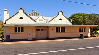
The Shire of Broomehill was a local government area in the Great Southern region of Western Australia, about 20 kilometres (12 mi) south of Katanning and about 310 kilometres (193 mi) south-southeast of the state capital, Perth. The Shire covered an area of 1,173 square kilometres (453 sq mi), and its seat of government was the town of Broomehill.

<span class="mw-page-title-main">Shire of Tambellup</span> Local government area in Western Australia

The Shire of Tambellup was a local government area in the Great Southern region of Western Australia, about 40 kilometres (25 mi) south of Katanning and about 330 kilometres (205 mi) south-southeast of the state capital, Perth. The Shire covered an area of 1,436 square kilometres (554 sq mi), and its seat of government was the town of Tambellup.

<span class="mw-page-title-main">Shire of Broomehill–Tambellup</span> Local government area in Western Australia

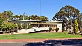
The Shire of Broomehill-Tambellup is a local government area in the Great Southern region of Western Australia, 320 kilometres (200 mi) south-southeast of the state capital, Perth. The Shire covers an area of 2,609.1 square kilometres (1,007.4 sq mi), and its seat of government is the town of Tambellup. It came into existence in 2008 through the amalgamation of the former Shire of Broomehill and Shire of Tambellup.

The Ongerup Branch railway, also known as the Tambellup, Gnowangrup to Ongerup railway is a former railway in Western Australia.

<span class="mw-page-title-main">Tunney, Western Australia</span> Town in Western Australia

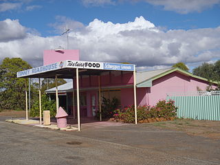
Tunney is a town located along the Albany Highway between Kojonup and Cranbrook, in the Shire of Broomehill-Tambellup in the Great Southern region of Western Australia.

<i>Great Southern Herald</i>


The Great Southern Herald is a weekly newspaper published in Katanning, Western Australia. It is distributed to communities in Katanning, Kojonup, Cranbrook, Gnowangerup and Lake Grace.

<span class="mw-page-title-main">John Moir (settler)</span>

John Moir was a settler and pastoralist in the areas to the east of Albany, in the Great Southern region of Western Australia.

References

  1. Australian Bureau of Statistics (28 June 2022). "Broomehill Village (suburb and locality)". Australian Census 2021 QuickStats. Retrieved 28 June 2022.  OOjs UI icon edit-ltr-progressive.svg
  2. Australian Bureau of Statistics (28 June 2022). "Broomehill (suburb and locality)". Australian Census 2021.  OOjs UI icon edit-ltr-progressive.svg
  3. "News from Albany". The Inquirer and Commercial News . Vol. XLVIII, no. 1414. Western Australia. 31 July 1889. p. 4. Retrieved 26 December 2017 via National Library of Australia.
  4. "Broomehill Hotel". InHerit. Heritage Council of Western Australia. 15 July 1988. Retrieved 30 March 2018.
  5. "Albany Gateway - Telling Tales about Broomehill". 2003. Archived from the original on 21 July 2008. Retrieved 20 September 2008.
  6. "General News". The Inquirer and Commercial News . Vol. L, no. 1493. Western Australia. 21 May 1890. p. 2. Retrieved 26 December 2017 via National Library of Australia.
  7. "News of the Week". Western Mail . Vol. VI, no. 287. Western Australia. 13 June 1891. p. 27. Retrieved 26 December 2017 via National Library of Australia.
  8. 1 2 "History of country town names – B". Western Australian Land Information Authority. Archived from the original on 14 March 2022. Retrieved 27 September 2008.
  9. "Advertising". The Inquirer and Commercial News . Vol. LI, no. 17, 493. Western Australia. 7 December 1892. p. 2. Retrieved 26 December 2017 via National Library of Australia.
  10. "News and Notes". The West Australian . Vol. 14, no. 3, 854. Western Australia. 6 July 1898. p. 4. Retrieved 26 December 2017 via National Library of Australia.
  11. "Population of Western Australia". Western Mail . Perth, Western Australia: National Library of Australia. 22 April 1898. p. 23. Retrieved 31 May 2012.
  12. "Progress Association formed at Broomehill". Great Southern Herald . Vol. 4, no. 192. Western Australia. 19 July 1905. p. 3. Retrieved 26 December 2017 via National Library of Australia.
  13. "Football. Katanning v. Broomehill". Great Southern Herald . Vol. 6, no. 396. Western Australia. 27 July 1907. p. 4. Retrieved 26 December 2017 via National Library of Australia.
  14. "Co-Operation". The Southern Districts Advocate . Vol. 6, no. 289. Western Australia. 12 January 1920. p. 2. Retrieved 26 December 2017 via National Library of Australia.
  15. "Advance Katanning". The Southern Districts Advocate . Vol. 8, no. 55. Western Australia. 28 November 1921. p. 2. Retrieved 26 December 2017 via National Library of Australia.
  16. "CBH Receival Sites - Contact Details" (PDF). 2010. Archived from the original (PDF) on 18 March 2012. Retrieved 31 March 2013.
  17. "Sydney Morning Herald - Travel - Broomehill". The Sydney Morning Herald. 8 February 2004. Retrieved 27 September 2008.
  18. "Shire of Broomehill-Tambellup - - Tourist Sites". 2005. Archived from the original on 20 July 2008. Retrieved 27 September 2008.
  19. "Shire of Broomehill-Tambellup - Holland Track". 2005. Archived from the original on 19 July 2008. Retrieved 27 September 2008.
  20. "The Holland Track". Goldfields Tourism Network. Retrieved 26 December 2017.

Commons-logo.svg Media related to Broomehill, Western Australia at Wikimedia Commons