The River Torrens, is the most significant river of the Adelaide Plains. It was one of the main reasons for the siting of the city of Adelaide, capital of South Australia. It flows 85 kilometres (53 mi) from its source in the Adelaide Hills near Mount Pleasant, across the Adelaide Plains, past the city centre and empties into Gulf St Vincent between Henley Beach South and West Beach. The upper stretches of the river and the reservoirs in its watershed supply a significant part of the city's water supply.

The Port River is part of a tidal estuary located north of the Adelaide city centre in the Australian state of South Australia. It has been used as a shipping channel since the beginning of European settlement of South Australia in 1836, when Colonel Light selected the site to use as a port. Before colonisation, the Port River region and the estuary area were known as Yerta Bulti by the Kaurna people, and used extensively as a source of food and plant materials to fashion artefacts used in daily life.
Brown Hill or Brownhill may refer to:

The City of Mitcham is a local government area in the foothills of southern Adelaide, South Australia. Within its bounds is Flinders University, South Australia's third largest, and the notable, affluent suburb of Springfield which contains some of the city's most expensive properties.
The City of Burnside is a local government area in the South Australian city of Adelaide stretching from the Adelaide Parklands into the Adelaide foothills with an area of 2,753 hectares. It was founded in August 1856 as the District Council of Burnside, the name of a property of an early settler, and was classed as a city in 1943. The LGA is bounded by Adelaide, Adelaide Hills Council, Campbelltown, Mitcham, Norwood Payneham and St Peters and Unley.
O'Halloran Hill is a suburb in the south of Adelaide, South Australia, situated on the hills south of the O'Halloran Hill Escarpment, which rises from the Adelaide Plains and located 18 km from the city centre via the Main South Road. The suburb is split between the Cities of Marion and Onkaparinga, and it neighbours Happy Valley, Hallett Cove, Trott Park and Darlington. It includes a large area of farmland and commercial vineyards known as the Glenthorne Estate.

The Onkaparinga River, known as Ngangkiparri or Ngangkiparingga in the Kaurna language, is a river located in the Southern Adelaide region in the Australian state of South Australia. Rising in the Mount Lofty Ranges, the river's estuary extends from Old Noarlunga to the river's mouth between the suburbs of Port Noarlunga and Port Noarlunga South.
The Panalatinga Creek is an urban watercourse located in the southern suburbs of Adelaide in the Australian state of South Australia.

Morialta is a single-member electoral district for the South Australian House of Assembly. It is a 356 km2 electorate stretching from the Adelaide Hills to the outer eastern and north-eastern suburbs of Adelaide, taking in the suburbs and localities of Auldana, Ashton, Athelstone, Basket Range, Birdwood, Castambul, Cherryville, Cudlee Creek, Forest Range, Gumeracha, Highbury, Kenton Valley, Lenswood, Lobethal, Marble Hill, Montacute, Mount Torrens, Norton Summit, Rostrevor, Summertown, Teringie, Uraidla and Woodforde, as well as part of Chain of Ponds.
Fullarton Road is a main road in the South Australian capital city of Adelaide.

Brown Hill is a hill in the Australian state of South Australia located on the western edge of the Mount Lofty Ranges, 7 kilometres southeast of the centre of Adelaide, in the suburb of Brown Hill Creek. Brown Hill rises to 312 metres above sea level.
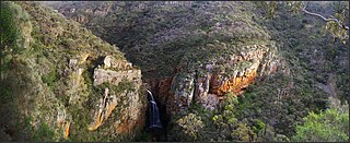
Morialta Conservation Park, formerly the Morialta Falls Reserve and the Morialta Falls National Pleasure Resort, is a protected area 10 km north-east of Adelaide city centre, in the state of South Australia, Australia. The park is in a rugged bush environment, with a narrow gorge set with three waterfalls, bounded by steep ridges and cliffs. The park caters to many activities, including bushwalking, bird watching and rock climbing.
Mitcham, formerly known as Mitcham Village, is an inner-southern suburb of Adelaide in the City of Mitcham.

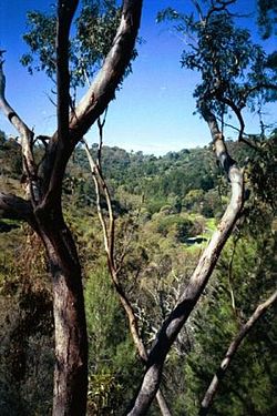
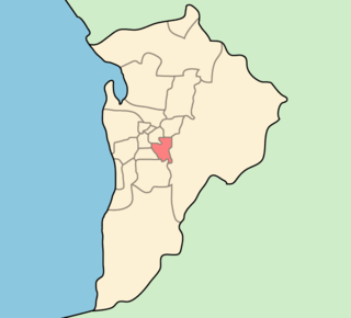
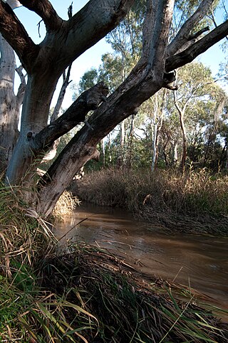
Brown Hill Creek is a south-eastern suburb of Adelaide in the City of Mitcham in South Australia, named in 1991 after Brown Hill Creek which flows from east to west through the locality. The creek itself was named after Brown Hill which rises immediately south-east of Mitcham village.

Brownhill Creek Recreation Park is a protected area located about 8 kilometres south of the Adelaide city centre in City of Mitcham along part of the course of the Brown Hill Creek. The recreation park was proclaimed under the National Parks and Wildlife Act 1972 in 1972 to "provide recreation opportunities for the Adelaide and eastern metropolitan region and to conserve remnant aged river red gums and the riparian zone habitat". The land previously subject to protected area status as a "National Pleasure Resort" since 1915. The recreation park is classified as an IUCN Category III protected area.

Cobbler Creek Recreation Park is a 266-hectare (657-acre) protected area located in South Australia about 19 kilometres (12 mi) north of the Adelaide city centre in the suburb of Salisbury East. Originally part of the lands of the Kaurna aboriginal people, it was farmed from European settlement of South Australia until the declaration of the park in 1989.

The Patawalonga River is a river located in the western suburbs of the Adelaide metropolitan area, in the Australian state of South Australia. It drains an area of flat, swampy lands formerly known as the Cowandilla Plains or The Reedbeds, which in the mid-20th century were drained by engineering works, enabling the establishment of Adelaide Airport and the development of residential housing.
The Sturt River, also known as the Sturt Creek and Warri Parri (Warriparri) in the Kaurna language, is a river located in the Adelaide region of the Australian state of South Australia.

Wirrina Cove is a locality and holiday resort on the Fleurieu Peninsula, South Australia. It is located between the coastal towns of Second Valley and Normanville on Yankalilla Bay. The holiday resort was developed from around 1972, and is located about 90 kilometres (56 mi) south of Adelaide.
Keswick Creek and Glen Osmond Creek together form a watercourse flowing through the inner south-eastern, south-western and western suburbs of the Adelaide metropolitan area, in the Australian state of South Australia. The watercourse is part of the Patawalonga River catchment.