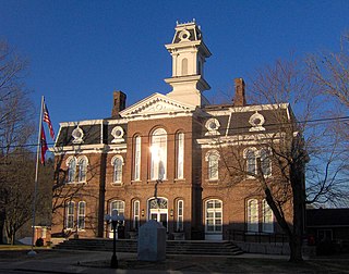
Smith County is a county in the U.S. state of Tennessee. As of the 2020 census, the population was 19,904. Smith County is located in the region of the state known as Middle Tennessee. Its county seat is Carthage. The county was organized in 1799 and is named for Daniel Smith, a Revolutionary War veteran who made the first map of Tennessee and served as a United States senator.

Sequatchie County is a county located in the U.S. state of Tennessee. As of the 2020 census, the population was 15,826. Its county seat is Dunlap. Sequatchie County is part of the Chattanooga, TN–GA Metropolitan Statistical Area.

Benton County is a county located in the U.S. state of Tennessee. As of the 2020 census, the population was 15,864. Its county seat is Camden. The county was created in December 1835 and organized in 1836.

Swain County is a county located on the far western border of the U.S. state of North Carolina. As of the 2020 census, the population was 14,117. Its county seat is Bryson City.

Madison County is a county located in the U.S. state of North Carolina. As of the 2020 census, the population was 21,193. Its county seat is Marshall. Madison County is part of the Asheville, NC Metropolitan Statistical Area.

Camden is a city in Benton County, Tennessee. The population was 3,674 at the 2020 census. It is the county seat of Benton County.

The Cumberland River is a major waterway of the Southern United States. The 688-mile-long (1,107 km) river drains almost 18,000 square miles (47,000 km2) of southern Kentucky and north-central Tennessee. The river flows generally west from a source in the Appalachian Mountains to its confluence with the Ohio River near Paducah, Kentucky, and the mouth of the Tennessee River. Major tributaries include the Obey, Caney Fork, Stones, and Red Rivers.

The Tombigbee River is a tributary of the Mobile River, approximately 200 mi (325 km) long, in the U.S. states of Mississippi and Alabama. Together with the Alabama, it merges to form the short Mobile River before the latter empties into Mobile Bay on the Gulf of Mexico. The Tombigbee watershed encompasses much of the rural coastal plain of western Alabama and northeastern Mississippi, flowing generally southward. The river provides one of the principal routes of commercial navigation in the southern United States, as it is navigable along much of its length through locks and connected in its upper reaches to the Tennessee River via the Tennessee-Tombigbee Waterway.
Brush Creek may refer to the following places in the United States:
Brush Creek is a 15.3-mile-long (24.6 km) tributary of Wills Creek in Pennsylvania in the United States.
Brush Creek is a 24.7-mile-long (39.8 km) tributary of the Raystown Branch Juniata River in Fulton and Bedford counties, Pennsylvania, in the United States.
Elk Creek is a 19.2-mile-long (30.9 km) tributary of Pine Creek in Centre County, Pennsylvania in the United States. Via Penns Creek, it is part of the Susquehanna River watershed.

Brush Creek Township is one of the sixteen townships of Scioto County, Ohio, United States. The 2010 census counted 1,199 people in the township, 1,112 of whom lived in the unincorporated parts of the township.

Defeated is an unincorporated community in Smith County, Tennessee, United States. It is located northeast of Carthage along Defeated Creek, a tributary of the Cumberland River. State Route 85 passes through the community.
Spring Creek is an unincorporated community in Madison County, Tennessee, United States. The zipcode is 38378.
Brush Creek is an unincorporated community in Sequatchie County, Tennessee, United States.
Brush Creek is an unincorporated community in northwestern Williamson County, Tennessee, United States.
New Middleton is an unincorporated community in Smith County, Tennessee, United States, located approximately 4 miles (6.4 km) west of Gordonsville.
This page is based on this
Wikipedia article Text is available under the
CC BY-SA 4.0 license; additional terms may apply.
Images, videos and audio are available under their respective licenses.


