Defeated, Tennessee

Last updated
Defeated, Tennessee
Defeated-Tennessee-tn.jpg
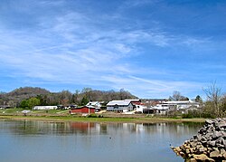
Buildings and houses in Defeated
USA Tennessee location map.svg
Red pog.svg
Defeated, Tennessee
Usa edcp location map.svg
Red pog.svg
Defeated, Tennessee
Coordinates: 36°19′35″N85°54′30″W / 36.32639°N 85.90833°W / 36.32639; -85.90833 Coordinates: 36°19′35″N85°54′30″W / 36.32639°N 85.90833°W / 36.32639; -85.90833
Country United States
State Tennessee
County Smith
Elevation
551 ft (168 m)
Time zone UTC-6 (Central (CST))
  Summer (DST) UTC-5 (CDT)
ZIP code
37030
Area code 615
GNIS feature ID1306322 [1]

Defeated is an unincorporated community in Smith County, Tennessee, United States. [1] It is located northeast of Carthage along Defeated Creek, a tributary of the Cumberland River (the lower part of the creek and the adjacent section of the river are both part of Cordell Hull Lake). State Route 85 passes through the community.

Defeated is named for the events that took place in the late 18th century along the banks of Defeated Creek. John Peyton, one of the earliest settlers and explorers of Smith County, and his surveying party were camped along the creek when they were attacked by a band of Cherokees led by Hanging Maw and driven out of the area. [2]

Defeated was the site of a post office from 1824 until 1929. The post office had the name Montrose from 1824 through 1880, when the name was changed to Defeated. [3]

Defeated is home to the Defeated Creek Marina, which lies along the Defeated Creek section of Cordell Hull Lake. The marina is home to a boat dock and ramp, rental cabins, and numerous recreational facilities. [4]

Related Research Articles

<span class="mw-page-title-main">Pickett County, Tennessee</span> County in Tennessee, United States

Pickett County is a county located in the U.S. state of Tennessee. As of the 2020 census, the population was 5,001, making it the least populous county in Tennessee. Its county seat is Byrdstown. The city of Byrdstown and the Kentucky town of Albany, 11 miles (18 km) to the northeast, are positioned between two Army Corps of Engineers lakes: Dale Hollow Lake, mainly in Tennessee, and Lake Cumberland, in Kentucky. The area is known as "Twin Lakes" and Byrdstown is noted as "The Gateway To Dale Hollow Lake". Every year thousands of people vacation at the many resorts situated along the lakes.

<span class="mw-page-title-main">Grainger County, Tennessee</span> County in Tennessee, United States

Grainger County is a county located in the U.S. state of Tennessee. As of the 2020 census, the population was 23,527. Its county seat is Rutledge. Grainger County is a part of both the Knoxville Metropolitan Statistical Area and Morristown Metropolitan Statistical Area.

<span class="mw-page-title-main">Celina, Tennessee</span> City in Tennessee, United States

Celina is a city in and the county seat of Clay County, Tennessee, United States. The population was 1,495 at the 2010 census.

<span class="mw-page-title-main">Carthage, Tennessee</span> Town in Tennessee, United States

Carthage is a town in and the county seat of Smith County, Tennessee, United States; it is part of the Nashville Metropolitan Statistical Area. The population was 2,306 at the 2010 census. It is located on the Cumberland River, which was important to its early development. It is likely best known as the hometown of former Vice President and Senator Al Gore of the Democratic Party and his father, Senator Albert Gore, Sr. The younger Gore announced his 1988 and 2000 presidential bids, as well as his 1992 vice-presidential bid, from the steps of the Smith County Courthouse.

<span class="mw-page-title-main">Cordell Hull</span> American politician (1871–1955)

Cordell Hull was an American politician from Tennessee and the longest-serving U.S. Secretary of State, holding the position for 11 years (1933–1944) in the administration of President Franklin Delano Roosevelt during most of World War II. Before that appointment, Hull represented Tennessee for two years in the United States Senate and 22 years in the House of Representatives.

<span class="mw-page-title-main">Cumberland River</span> River in Kentucky and Tennessee, United States

The Cumberland River is a major waterway of the Southern United States. The 688-mile-long (1,107 km) river drains almost 18,000 square miles (47,000 km2) of southern Kentucky and north-central Tennessee. The river flows generally west from a source in the Appalachian Mountains to its confluence with the Ohio River near Paducah, Kentucky, and the mouth of the Tennessee River. Major tributaries include the Obey, Caney Fork, Stones, and Red rivers.

<span class="mw-page-title-main">French Broad River</span> River in North Carolina and Tennessee, United States

The French Broad River is a river in the U.S. states of North Carolina and Tennessee. It flows 218 miles (351 km) from near the town of Rosman in Transylvania County, North Carolina, into Tennessee, where its confluence with the Holston River at Knoxville forms the beginning of the Tennessee River. The river flows through the counties of Transylvania, Buncombe, Henderson, and Madison in North Carolina, and Cocke, Jefferson, Sevier, and Knox in Tennessee. It drains large portions of the Pisgah National Forest and the Cherokee National Forest.

<span class="mw-page-title-main">Calfkiller River</span> River in Tennessee, United States

The Calfkiller River is a 42.4-mile-long (68.2 km) stream in the east-central portion of Middle Tennessee in the United States. It is a tributary of the Caney Fork, and is part of the Cumberland, Ohio, and Mississippi watersheds. The river is believed to be named for a Cherokee chief who once lived in the area.

<span class="mw-page-title-main">Caney Fork River</span> River in Tennessee, United States

The Caney Fork River is a river that flows through central Tennessee in the United States, draining a substantial portion of the southwestern Cumberland Plateau and southeastern Highland Rim regions. It is a major tributary of the Cumberland River, and is part of the Cumberland, Ohio and Mississippi basins. The river is 143 miles (230 km) long, and its watershed covers 1,771 square miles (4,590 km2) in eleven counties. Monterey, Baxter, Sparta, Smithville, McMinnville, Altamont, Spencer and Gordonsville are among the towns that are at least partially drained by the river.

<span class="mw-page-title-main">Old Hickory Lake</span> Reservoir of the Cumberland River in Tennessee, United States

Old Hickory Lake is a reservoir in north central Tennessee. It is formed by the Old Hickory Lock and Dam, located on the Cumberland River at mile 216.2 in Sumner and Davidson counties, approximately 25 miles (40 km) upstream from Nashville.

<span class="mw-page-title-main">Cordell Hull Birthplace State Park</span> State park in Tennessee, United States

Cordell Hull Birthplace State Park is a state park in Pickett County, Tennessee, in the southeastern United States. Cordell Hull (1871–1955) served as U.S. Secretary of State under President Franklin Roosevelt and played a pivotal role in the creation of the United Nations in the mid-1940s.

Olympus was a community in Pickett County, Tennessee, that was once the site of a post office and was the birthplace of U.S. Secretary of State Cordell Hull.

Sharps Chapel is an unincorporated community in southwestern Union County, Tennessee, along the northern shore of Norris Lake.

<span class="mw-page-title-main">Fort Blount</span> United States historic place

Fort Blount was a frontier fort and federal outpost located along the Cumberland River in Jackson County, Tennessee, United States. Situated at the point where Avery's Trace crossed the river, the fort provided an important stopover for migrants and merchants travelling from the Knoxville area to the Nashville area in the 1790s. After the fort was abandoned around 1800, the community of Williamsburg developed on the site and served as county seat for the newly formed Jackson County from 1807 and 1819. The fort and now vanished village sites were added to the National Register of Historic Places in 1974.

Defeated Creek is a stream in Smith County, Tennessee, in the United States.

<span class="mw-page-title-main">Tennessee State Route 53</span>

State Route 53 (SR 53) is a north–south state highway that traverses six counties in Middle Tennessee. It is 113.5 miles (182.7 km) long.

<span class="mw-page-title-main">Tennessee State Route 85</span>

State Route 85 is an east-west state highway in Middle Tennessee. The 83.4 miles (134.2 km)-long road traverses portions of Smith, Jackson, Overton, and Fentress Counties.

Eastport is an unincorporated community in Tishomingo County, Mississippi, United States. During the 1840s and 1850s, Eastport became an important river port and boasted a population of 2,000 and many businesses. In 1857, the railroad missed Eastport and the townspeople began moving to nearby Iuka. During the American Civil War, the town again became an important river port, but by the 1890s the post office closed. When the Tennessee River was dammed to create Pickwick Lake in the 1930s, the old town was submerged. Eastport still exists as a small community with a marina.

Indian Creek, also known as Big Indian Creek, is a large stream in western Putnam County, Tennessee. It is a tributary of the Caney Fork River.

Willow Grove was a small town in eastern Clay County, Tennessee, United States. Named for the willow trees in the area, the town was located 13 miles (21 km) due east of Celina. It was located along the banks of Iron Creek, a tributary of the Obey River.

References

  1. 1 2 "Defeated, Tennessee". Geographic Names Information System . United States Geological Survey, United States Department of the Interior.
  2. Edward Albright, Early History of Middle Tennessee (Brandon Printing Company, 1909), p. 120.
  3. Post Offices and Post Masters for Smith County, Smith County Genealogy website, accessed December 22, 2009
  4. Defeated Creek Marina. Official website. Accessed: 7 April 2017.