The City of Manningham is a local government area in Victoria, Australia in the north-eastern suburbs of Melbourne and is divided into 12 suburbs, with the largest being Doncaster and Doncaster East. It comprises an area of 113 square kilometres and had a population of 125,508 in June 2018.

Balwyn North, also known as North Balwyn, is a suburb of Melbourne, Victoria, Australia, 10 km east of Melbourne's Central Business District, located within the Cities of Boroondara and Whitehorse local government areas. Balwyn North recorded a population of 21,302 at the 2021 census.

Bulleen is an eastern suburb in Melbourne, Australia, 13 km north-east of the Melbourne central business district, located within the City of Manningham local government area. Bulleen recorded a population of 11,219 at the 2021 census.

Doncaster is a suburb of Melbourne, Victoria, Australia, 18 km north-east of Melbourne's Central Business District, located within the City of Manningham local government area. Doncaster recorded a population of 25,020 at the 2021 census.

Templestowe is a suburb of Melbourne, Victoria, Australia, 16 km north-east of Melbourne's Central Business District, located within the City of Manningham local government area. Templestowe recorded a population of 16,966 at the 2021 census.

The Eastern Freeway is an urban freeway in eastern Melbourne, the state capital of Victoria, Australia. It is one of the most important freeways in terms of commuting to the city, connecting Alexandra Parade and Hoddle Street in the inner suburbs, with EastLink tollway farther east. It consists of between three and six lanes in each direction, also an inbound transit lane reserved for vehicles with two or more occupants during peak hours.
Maroondah Highway is a major east–west thoroughfare in the eastern suburbs of Melbourne, and a highway connecting the north-eastern fringes of Melbourne to the lower alpine region of Victoria, Australia.
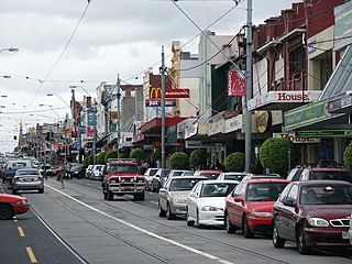
Burke Road is a major north–south thoroughfare in Melbourne, Australia. It runs from Ivanhoe East to Caulfield East and through the major shopping district at Camberwell.
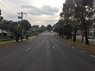
Mickleham Road is a secondary road located in Victoria, Australia, north of Melbourne.
Westall Road is a major north to south thoroughfare west of Springvale, Victoria, Australia.
Greensborough Highway is a highway in the north-eastern suburbs of Melbourne, Australia, and is an important route for north-east Melbourne. This name is not widely known to most drivers, as the entire allocation is still best known as by the names of its constituent parts: Lower Heidelberg Road, Rosanna Road, Lower Plenty Road, Greensborough Road and Greensborough Bypass. This article will deal with the entire length of the corridor for sake of completion, as well to avoid confusion between declarations.
Thompson Road is a major urban arterial road in the south-eastern suburbs of Melbourne, Victoria, Australia.
Western Port Highway is a highway in Victoria, Australia, linking the south-eastern fringe of suburban Melbourne to the western coast of Western Port, after which the highway is named, at the Port of Hastings nearly 30 km to the south. It runs from the end of South Gippsland Freeway at Lynbrook, firstly as a dual carriageway and later as an undivided road, to Frankston-Flinders Road at Hastings.
Warrigal Road is a major inner urban road in southeastern Melbourne, Australia. On weekdays, it is heavily trafficked as it runs through many major suburbs along its route, traversing some of Melbourne's eastern and south-eastern suburbs. These suburbs include Chadstone, Oakleigh, and Cheltenham. The Chadstone Shopping Centre can be accessed directly from Warrigal Road at its eastern entrance.

State (Bell/Springvale) Highway, also known as Bell Street/Springvale Road State Highway, is the longest self-contained urban highway in Melbourne, Australia, linking Tullamarine Freeway and Nepean Highway through Melbourne's north-eastern suburbs. These names are not widely known to most drivers, as the entire allocation is still best known as by the names of its constituent parts : Bell Street, Banksia Street, Manningham Road, Williamsons Road, Doncaster Road, Mitcham Road, Springvale Road and Edithvale Road. This article will deal with the entire length of the corridor for sake of completeness, as well to avoid confusion between declarations.

The Doncaster railway line was a long-proposed suburban railway in the eastern suburbs of Melbourne, Victoria, Australia, that was anticipated to be built by the late 2020s, as a branch, along with the Hurstbridge line, of the planned future Clifton Hill Loop Line, as part of the 2013 PTV Network Development Plan.
Plenty Road is a major urban arterial road in the north-eastern suburbs of Melbourne, Victoria, Australia. Plenty Road begins at the intersection of High Street and Dundas Street in Preston, travelling through the north eastern suburbs of Reservoir, Bundoora, Mill Park, South Morang and Mernda and terminating in the township of Whittlesea, just outside the urban area of Melbourne.

Doncaster–Eltham Road is a major arterial road in the north-eastern suburbs of Melbourne, Victoria, Australia. This name is not widely known to most drivers, as the entire allocation is still best known as by the names of its constituent parts: Fitzsimons Lane and Williamsons Road. This article will deal with the entire length of the corridor for sake of completion, as well to avoid confusion between declarations.
The Eastern Express Busway is a proposed bus rapid transit line in the eastern suburbs of Melbourne, Australia. It would operate alongside the Eastern Freeway, from Hoddle Street in Abbotsford to Doncaster Road in Doncaster. As a part of the North East Link project and Eastern Freeway upgrade, the entire busway is expected to be commence construction in 2024 and be completed by 2028.

Bulleen Park and Ride is a park and ride bus station and future busway station located in Melbourne, Australia serving the suburb of Bulleen and situated next to the Eastern Freeway. It was opened on 30 April 2023 by the Victorian government as the first piece of public infrastructure delivered by the North East Link project.

