
Burlington County is a county in the South Jersey region of the U.S. state of New Jersey. The county is the largest by land area in New Jersey and ranks second behind Ocean Country in total area. Its county seat is Mount Holly. As of the 2020 census, the county was the state's 11th-most-populous county, with a population of 461,860, its highest decennial count ever and an increase of 13,126 (+2.9%) from the 448,734 recorded at the 2010 census, which in turn had reflected an increase of 25,340 (6.0%) from the 423,394 enumerated at the 2000 census. The most populous place in the county was Evesham Township with 46,826 residents as of the 2020 census. Washington Township covered 102.71 square miles (266.0 km2), the largest area of any municipality in the county.
Delanco Township is a township in Burlington County, in the U.S. state of New Jersey. As of the 2020 United States census, the township's population was 4,824, an increase of 541 (+12.6%) from the 2010 census count of 4,283, which in turn reflected an increase of 1,046 (+32.3%) from the 3,237 counted in the 2000 census. The township, and all of Burlington County, is a part of the Philadelphia-Reading-Camden combined statistical area and the Delaware Valley.

Palmyra is a borough in Burlington County, in the U.S. state of New Jersey. As of the 2020 United States census, the borough's population was 7,438, an increase of 40 (+0.5%) from the 2010 census count of 7,398, which in turn reflected an increase of 307 (+4.3%) from the 7,091 counted in the 2000 census. The borough, and all of Burlington County, is a part of the Philadelphia-Reading-Camden combined statistical area and the Delaware Valley.

Route 73 is a state highway in the southern part of the U.S. state of New Jersey. It runs 34.64 mi (55.75 km) as an outer bypass of the Camden area from an intersection with U.S. Route 322 (US 322) in Folsom, Atlantic County, north to the Tacony–Palmyra Bridge in Palmyra, Burlington County, where the road continues into Philadelphia, Pennsylvania, as Pennsylvania Route 73. South of the interchange with the Atlantic City Expressway in Winslow Township, Camden County, Route 73 is a two-lane undivided county-maintained road and is signed as County Route 561 Spur, a spur of CR 561. North of the Atlantic City Expressway, the route is maintained by the New Jersey Department of Transportation and is mostly four lanes, with the portion north of the CR 561 concurrency a divided highway. North of the US 30 interchange near Berlin, Route 73 runs through suburban areas of the Delaware Valley metropolitan area, intersecting Route 70 in Marlton, the New Jersey Turnpike and Interstate 295 (I-295) in Mount Laurel Township, Route 38 and Route 41 in Maple Shade Township, Route 90 in Cinnaminson Township, and US 130 in Pennsauken Township.

U.S. Route 130 is a U.S. Highway that is a spur route of US 30, located completely within the state of New Jersey. It is signed with north and south cardinal directions, following a general northeast–southwest diagonal path, with north corresponding to the general eastward direction and vice versa. The route runs 83.46 mi (134.32 km) from Interstate 295 (I-295) and US 40 at Deepwater in Pennsville Township, Salem County, where the road continues south as Route 49, north to US 1 in North Brunswick Township, Middlesex County, where Route 171 continues north into New Brunswick. The route briefly runs concurrent with US 30 near Camden, about one-third of the way to New Brunswick. The road runs within a close distance of I-295 south of Bordentown and a few miles from the New Jersey Turnpike for its entire length, serving as a major four- to six-lane divided local road for most of its length. US 130 passes through many towns including Penns Grove, Bridgeport, Westville, Camden, Pennsauken, Burlington, Bordentown, Hightstown, and North Brunswick.
Route 90 is a 3.22-mile (5.18 km) state highway in New Jersey in the United States (U.S.). The western terminus is at the Betsy Ross Bridge over the Delaware River in Pennsauken Township, Camden County, where the road continues into Philadelphia, Pennsylvania, as an unnumbered road that provides access to Interstate 95 (I-95). The eastern terminus is an interchange with Route 73 in Cinnaminson Township, Burlington County. It is a four- to six-lane freeway its entire length, interchanging with U.S. Route 130 and County Route 644.

Route 413 is a 0.76-mile-long (1.22 km) state highway located entirely in the City of Burlington, New Jersey, United States. It is an eastward extension into New Jersey of the longer Pennsylvania Route 413 (PA 413). The western terminus is in the middle of the Burlington–Bristol Bridge crossing of the Delaware River at the New Jersey–Pennsylvania state border; the eastern terminus is at an intersection with U.S. Route 130 (US 130) and County Route 543 (CR 543). Prior to the 1953 renumbering, Route 413 was Route S25, a prefixed spur of Route 25.

The Tacony–Palmyra Bridge is a combination steel tied-arch and double-leaf bascule bridge across the Delaware River that connects New Jersey Route 73 in Palmyra, New Jersey with Pennsylvania Route 73 in the Tacony section of Philadelphia. The bridge, designed by Polish-born architect Ralph Modjeski, has a total length of 3,659 feet (1,115 m) and spans 2,324 feet (708 m). After one and a half years of construction, it opened on August 14, 1929, replacing ferry service that had operated between Tacony and Palmyra since May 6, 1922.

The Burlington–Bristol Bridge is a truss bridge with a lift span crossing the Delaware River from Burlington, New Jersey to Bristol Township, Pennsylvania in the United States. Construction of the bridge started on April 1, 1930, and the bridge opened to traffic on May 2, 1931. The bridge carries New Jersey Route 413 and Pennsylvania Route 413 (PA 413).
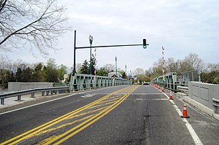
The Riverside–Delanco Bridge is a truss bridge with a central swing span that carries CR 543 across the Rancocas Creek, between Riverside and Delanco in New Jersey. The current bridge was built in 1934-1935 to replace the 1901 bridge, which itself replaced an 1870 structure. It is currently managed by the Burlington County Bridge Commission.

The Betsy Ross Bridge, also known as the Ross Memorial Bridge, is a continuous steel truss bridge spanning the Delaware River from Philadelphia, Pennsylvania to Pennsauken, New Jersey. It was built from 1969 to 1974, and opened in April 1976, during the American Bicentennial Year. It was originally planned to be named as the "Delair Bridge", after a paralleling vertical lift bridge owned by Pennsylvania Railroad, which is now used by Conrail Shared Assets Operations and New Jersey Transit's Atlantic City Line, but was instead later named for Betsy Ross, a Philadelphia seamstress and creator of the first American flag in 1776. It was the first automotive bridge named for a woman in the United States, and the second U.S. bridge overall named for a woman after Iowa's Boone High Bridge was renamed the Kate Shelley High Bridge in 1912.
Route 25 was a major state highway in New Jersey, United States prior to the 1953 renumbering, running from the Benjamin Franklin Bridge in Camden to the Holland Tunnel in Jersey City. The number was retired in the renumbering, as the whole road was followed by various U.S. Routes: US 30 coming off the bridge in Camden, US 130 from the Camden area north to near New Brunswick, US 1 to Tonnele Circle in Jersey City, and US 1 Business to the Holland Tunnel.

Interstate 295 (I-295) in Delaware, New Jersey, and Pennsylvania is an auxiliary Interstate Highway, designated as a bypass around Philadelphia, Pennsylvania, and a partial beltway of Trenton, New Jersey.

Frankford Creek is a minor tributary of the Delaware River in southeast Pennsylvania. It derived its name from the nearby town of Frankford, Philadelphia County. The stream originates as Tookany Creek at Hill Crest in Cheltenham Township and meanders eastward, then southeastward, throughout Cheltenham Township, until a sharp bend near the Philadelphia border at Lawncrest, where the place names Toxony and Tookany were used in historic times; the stream is still known as Tookany Creek in this region, where it flows southwest. Turning south into Philadelphia at the crotch of Philadelphia's V-shaped border, the creek is called Tacony Creek; from here southward, it is considered the informal boundary separating Northeast Philadelphia from the rest of the city. The Philadelphia neighborhoods of Olney and Feltonville lie on the western side of the stream in this area while Northwood, Lawncrest, Summerdale, and Frankford lie on the eastern side. It continues to be called the Tacony at least until the smaller Wingohocking Creek merges with it in Juniata Park, within the city-owned golf course. Beyond Castor Avenue it is known as Frankford Creek until the stream's confluence with the Delaware River in the Bridesburg neighborhood of Philadelphia. The section of stream known as Frankford Creek is 3.1 miles (5.0 km) long, and the upstream section known as Tacony Creek, from Hill Crest, is 11.1 miles (17.9 km) long.

The Delaware River–Turnpike Toll Bridge is a four-lane, steel through arch bridge crossing the Delaware River between Burlington Township, Burlington County, New Jersey and Bristol Township, Bucks County, Pennsylvania. As a part of Interstate 95 (I-95), it is a major highway link between Philadelphia and New York City. The bridge also connects the Pennsylvania Turnpike's east-west mainline with the main trunk of the New Jersey Turnpike, via the Pearl Harbor Memorial Turnpike Extension. Tolls are collected only in the west/southbound direction via electronic toll collection.
Tacony is a historic neighborhood in Northeast Philadelphia, United States, approximately 8 miles (13 km) from downtown Philadelphia. It is bounded by the east side of Frankford Avenue on the northwest, the south side of Cottman Avenue on the northeast, the north side of Robbins Street on the southwest, and the Delaware River and Interstate 95 on the southeast.

County Route 543 is a county highway in the U.S. state of New Jersey. The highway extends 28.77 miles (46.30 km) from Federal Street in Camden to Wrightstown-Georgetown Road in Mansfield Township.

Interstate 895 (I-895) was a planned 6.4-mile-long (10.3 km) auxiliary Interstate Highway in New Jersey and Pennsylvania that would have provided a freeway between I-295 near Burlington in Burlington County, New Jersey, and I-95 near Bristol in Bucks County, Pennsylvania.

Route 155 was a short state highway in the community of Palmyra, New Jersey in Burlington County. The route ran from the ferry docks to the north of the Tacony–Palmyra Bridge (Route 73) through the community, terminating at an intersection with U.S. Route 130. The highway was a former alignment of Route 73 before the construction of the bridge. The route originated as Route S41N in the 1927 renumbering. The route was decommissioned and turned over to Burlington County, who designated it as an extension of County Route 607.

Pennsylvania Route 73 (PA 73) is a 62.32-mile (100.29 km) long east–west state highway in southeastern Pennsylvania. It runs from PA 61 near Leesport southeast to the New Jersey state line on the Tacony–Palmyra Bridge over the Delaware River in Philadelphia, where the road continues south as New Jersey Route 73. The route passes through rural areas of Berks County, crossing U.S. Route 222 (US 222) in Maiden Creek before heading southeast through Oley and Boyertown. PA 73 continues into Montgomery County and intersects PA 100 in Gilbertsville and PA 29 in Schwenksville before it heads into the northwest suburbs of Philadelphia. The route passes through Skippack and intersects US 202 in Center Square, PA 309 in Springfield Township, and PA 611 near Jenkintown. PA 73 continues through Northeast Philadelphia on Cottman Avenue, crossing US 1 and US 13 before coming to an interchange with Interstate 95 (I-95) near the Tacony–Palmyra Bridge.
