Burntcoat Head, Nova Scotia

Last updated

Burntcoat Head Park BurntCoat Head Park.jpg
Burntcoat Head Park

Burntcoat Head (improperly known as Burncoat) is an unincorporated rural Canadian community in Hants County, Nova Scotia. The area is known for having the largest tidal range (the greatest difference in height between high tide and low tide) of any location in the world. It is also home to Burntcoat Head Park, which offers public access to the ocean floor.

Contents

Etymology

The origin of the name "Burntcoat" or "Burncoat", as the community is sometimes named, is unknown. The derivation of the spelling of the name is also unclear. Today the village on the west side of the Noel Bay is named Burntcoat, however, the Acadians named the village on the east side of the Noel Bay "Pointe Brull" (i.e., Burnt Point or Burnt Coast). Perhaps the Protestant settlers who came after the exodus of the Acadians from the community confused the names for the east and west side of the Noel Bay and thought the west side of the bay was "Pointe Brull".

The Acadian name for west side of Noel Bay (i.e., present day Burntcoat) was "Pointe Cloche", indicating a chapel was likely located on the west side of the bay at Noel, Nova Scotia. [1]

Tidal range

Burntcoat Head is located in Cobequid Bay, near the eastern end of the Bay of Fundy. Burntcoat Head had a public wharf that has been the location of a tide gauge since the 19th century. The tide gauge at Burntcoat Head was operated by the Canadian Hydrographic Service and has recorded the highest tidal range in the world. Currently, the tidal gauge is no longer in operation. Tides at Burntcoat Head average 55.8 ft (17.0 m), with the highest being set during the 1869 Saxby Gale at 70.9 ft (21.6 m).

The Guinness Book of World Records (1975) declared that Burntcoat had the highest tides in the world:

“The Natural World, Greatest Tides: The greatest tides in the world occur in the Bay of Fundy.... Burntcoat Head in the Minas Basin, Nova Scotia, has the greatest mean spring range with 14.5 metres (47.5 feet) and an extreme range of 16.3 metres (53.5 feet).”

The National Geographic magazine (August 1957) also made a similar assertion: “The famous tides of the Bay of Fundy move with deceptive quiet. Sheltered from the open sea, they ebb and flood to a recorded range unequal in the rest of the world.”

Like pretty much every place along the ocean around the world, Burntcoat Head experiences two high tides and two low tides each day. The Bay of Fundy fills and empties with approximately 160 billion tonnes of water twice a day. On average it takes 6 hours and 13 minutes between high and low tide. As soon as the tide has reached its lowest or highest point it will change directions and either begin to come to shore or flow back out. The tide times change by approximately by one hour daily. [2]

Spring tides happen twice a month when the sun, moon, and earth are aligned. During this alignment the tides rise higher than average. [3] Neap tides occur during the first and third quarter moon. During this time the high tides heights are lower than average. [4]

Ecosystems

At low tide the ocean floor becomes exposed allowing different species and ecosystems to be found along the shoreline and within tide pools. Barnacles, periwinkles, slipper limpets, moon snails, horse mussels, leafy bryozoa, and whelks can commonly be found.

A publicly accessible staircase leads down to the ocean floor at Burntcoat Head Park. Burntcoat Head Park ocean floor access.jpg
A publicly accessible staircase leads down to the ocean floor at Burntcoat Head Park.

[5] Atlantic mud-piddock (and the similar, but separate False Angel Wing) can be found burrowed into the sandstone. Dead man's fingers and mermaid's glove which are sponges can be found washed up on shore. [6] The five main crab species that can be found within the tidal pools are green crab, hermit crab, lady crab, toad crab, and rock crab. [7] Fish species that are sometimes found in tidal pools include tommy cod, Atlantic mackerel, smallmouth bass, eels, monkfish, and flounder. [8]

Burntcoat Head is a popular location for migrating shorebirds, which include sandpipers, whimbrels, yellowlegs, willets, and plovers. During low tide when mud flats are exposed the birds will consume mud shrimps before heading south for the winter months. [9]

The intertidal area of Burntcoat Head's shoreline is identified as a Critical Habitat for the Atlantic Mud-Piddock (Barnea truncata). The Atlantic Mud-piddock was listed as threatened under the Species at Risk Act (SARA) in 2017. It is a species of bivalve mollusk that burrows exclusively into red mudstone in the intertidal zone of the Minas Basin. To help reduce human impact on this habitat, visitors to Burntcoat Head Park will notice signage and directives to help avoid disturbing the delicate habitat of the Atlantic Mud-Piddock while exploring the ocean floor.

From mid-May to mid-October, guided tours are offered by the Park to provide a shoreline exploration during low tide. Visitors can experience hands-on learning about shorelife ecosystems that live within the tidal pools and mudflats. Visitors will also learn about the tides and history of the shorelines of Burntcoat and surrounding areas. [10]

Geology

Burntcoat is a part of the Triassic Lowlands Region. The Minas Basin and Cobequid Bay was formed from rivers that eroded from the Bay of Fundy. Burntcoat Head shoreline and ocean floor is made from Triassic red sandstones and conglomerates. [11] Fossils and bones of animals that travelled the Triassic Lowland Region can be found within the rocks of Burntcoat Head. Over the years skulls from an archosaur known as Teraterpetion and backbones of a dicynodont have been found within the rocks along the shoreline. [12]

The sandstone shoreline in the area erodes from the sea level rising and falling, as well as from the currents produced by the tides. Erosion causes sediment of sand, pebbles, and mud to be washed up and down the Cobequid Bay with the incoming and outgoing tides. The sediment forms sand bars along the shorelines, as well as in the Shubenacadie River. [13]

History

Burntcoat Head and its wider geographical region was inhabited by the Mi'kmaw first nations for thousands of years. The name of the Cobequid Bay on which the community is located is derived from the Mi'kmaq word We'kopekwitk (also spelled Wagobagitk) meaning "the bay runs far up".

The first document settlers of Burntcoat Head were the Acadians in the 16th century. Noel Doiron and his family built a chapel in Burntcoat on the west side of the Noel Bay, when Burntcoat was known as "Steeple Point". The Acadians in the Noel Bay vacated the community in 1750, a year after the founding of Halifax by the British. [14]

After the Acadians, the next prominent settlers were three Faulkner brothers, Thomas, William, and Robert (buried in Burntcoat), who were Ulster Scots people. Their maternal grandfather, Edward Faulkner (m. Martha Steward) emigrated from Ireland to Massachusetts; Edward died in 1756 in the Battle of Fort Oswego during the Seven Years' War. Edward's daughter Hannah married her adopted brother Robert Faulkner Sr. [15] and Thomas, William, and Robert were their sons. The family moved from Massachusetts and settled across the Cobequid Bay from Burntcoat in Londonderry Township, Nova Scotia (Glenholme). [16] During the 19th century there were a number of shipyards in Burntcoat and surrounding areas. The road on which Burntcoat Head Park is located is named Faulkner Lane in recognition of this family, who continued to own the land and operate the lighthouses(s) for several generations.

Lighthouses

The first Burntcoat lighthouse was erected to guide wooden sailing ships during the Golden Age of Sail in Nova Scotia. Built in 1858, the lighthouse was built on land which eventually became an island. The lighthouse had 5 oil lamps with reflectors that were cleaned daily. A narrow neck of land connected it with the mainland. After the strip of land was eroded, the inhabitants went to and from the lighthouse by climbing up and down the bank by means of a ladder. There were five kerosene lamps that were cleaned and lit every evening. The lighthouse keeper of the first lighthouse saw the crashing of the schooner the Only Son (1898). This vessel belonged to the Mariner of Minasville, Captain William Scott. The vessel was being sailed by his sons in a storm and was dashed to pieces off the rocks of Burntcoat. The sons survived and the only part of the vessel that remains is the vessel's guiding light. The first lighthouse was eventually lost to erosion of the coast.[ citation needed ]

Thomas Faulkner and the Lighthouse, The Hants Journal 7 October 1931 ThomasFaulkner.jpg
Thomas Faulkner and the Lighthouse, The Hants Journal 7 October 1931

The second lighthouse was built on the mainland in 1913, on the site of where its replica sits today. The lighthouse was kept by William Faulkner and his family, on whose land the lighthouse was built. The gas light in this house was raised every evening on a 76 ft. tower. It was converted to an electric light in 1950.

During the Great Depression, a German mail plane crashed off the coast at 3:30 am on 6 October 1931. Many local residents, including the lighthouse keeper Thomas Faulkner, heard the loud roar of the plane over their homes and then an explosion in the bay and then silence. [17] Fifteen minutes after the crash, Faulkner heard screams from the water. He made his way to the nearby Noel wharf to see if a rescue boat was available. There was a schooner, however, Faulkner had to wait for an hour before the tide was high enough to push it off. While he waited, the pilots continued to scream. After an hour, as the schooner began to float, the pilots fell silent. After a twelve-hour search, the bodies of the pilots were not found. The only remnant of the plane that was found was the gas tank. A week later, a pilot's body was found by a passing tugboat. Immediately after the event, Thomas Faulkner reported that he thought he could have saved the men had he had a boat ready. The local newspaper reported that the crew were trying to set a record for mail delivery from Europe to New York.[ citation needed ]

The second lighthouse burned in 1972. To commemorate the history of the lighthouse and the site where the highest tides in the world have been recorded, the community rebuilt the lighthouse in 1994. Burntcoat Head Park is currently operated by the Municipality of East Hants and operates seasonally during the months May–October. [18] Burntcoat Head park contains a replica lighthouse, walking trails and displays that interpret the natural and human history of the Minas Basin. The replica lighthouse contains a gift shop and more interpretive panels that provide information about the tides, past lighthouses, and history about the surrounding area. [19] Burntcoat has one of the only two lighthouses remaining in all of Hants county. The other lighthouse is in Walton, Nova Scotia.[ citation needed ]

A photo taken in 2022 of the replica lighthouse (built in 1994) at Burntcoat Head Park, East Hants, Nova Scotia. Burntcoat Head Replica Lighthouse.jpg
A photo taken in 2022 of the replica lighthouse (built in 1994) at Burntcoat Head Park, East Hants, Nova Scotia.
The Replica Lighthouse Burntcoat Head Lighthouse.jpg
The Replica Lighthouse

Lighthouse keepers:

Related Research Articles

<span class="mw-page-title-main">Bay of Fundy</span> Bay on the east coast of North America

The Bay of Fundy is a bay between the Canadian provinces of New Brunswick and Nova Scotia, with a small portion touching the U.S. state of Maine. It is an arm of the Gulf of Maine. Its tidal range is the highest in the world. The name is probably a corruption of the French word fendu, meaning 'split'.

<span class="mw-page-title-main">Hants County, Nova Scotia</span> County in Nova Scotia, Canada

Hants County is a historical county and census division of Nova Scotia, Canada. Local government is provided by the West Hants Regional Municipality, and the Municipality of the District of East Hants.

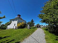
Windsor is a community located in Hants County, Nova Scotia, Canada. It is a service centre for the western part of the county and is situated on Highway 101.

Falmouth is a village located along the Avon River in Hants County between Mount Denson and Windsor in the Canadian province of Nova Scotia.

<span class="mw-page-title-main">Minas Basin</span>

The Minas Basin is an inlet of the Bay of Fundy and a sub-basin of the Fundy Basin located in Nova Scotia, Canada. It is known for its extremely high tides.

<span class="mw-page-title-main">Cobequid Bay</span> Inlet in Nova Scotia, Canada

Cobequid Bay is an inlet of the Bay of Fundy and the easternmost part of the Minas Basin, located in the Canadian province of Nova Scotia. The bay was carved by rivers flowing into the eastern end of the Bay of Fundy.

The Glooscap Trail is a scenic roadway in the Canadian province of Nova Scotia.

The Fundy Shore Ecotour is a former scenic drive and network of tourist destinations in the Canadian province of Nova Scotia and encircles several sub-basins of the Bay of Fundy, which contains the highest tidal range on the planet.

<span class="mw-page-title-main">Nova Scotia Route 215</span>

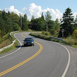
Route 215 is collector road in the Canadian province of Nova Scotia.

<span class="mw-page-title-main">Geography of Nova Scotia</span>

Nova Scotia is a province located in Eastern Canada fronting the Atlantic Ocean. One of the Maritime Provinces, Nova Scotia's geography is complex, despite its relatively small size in comparison to other Canadian provinces.

<span class="mw-page-title-main">Nova Scotia peninsula</span> Peninsula in Nova Scotia

The Nova Scotia peninsula is a peninsula on the Atlantic coast of North America. It is called Enmigtaqamu'g in the Mi'kmaw language.

<span class="mw-page-title-main">Salmon River (Nova Scotia)</span>

The Salmon River is a Canadian river in central Nova Scotia's Colchester County.

<span class="mw-page-title-main">Cape Chignecto Provincial Park</span> Provincial park in Nova Scotia, Canada

Cape Chignecto Provincial Park is a Canadian provincial park located in Nova Scotia. A wilderness park, it derives its name from Cape Chignecto, a prominent headland which divides the Bay of Fundy with Chignecto Bay to the north and the Minas Channel leading to the Minas Basin to the east. The park, which opened in 1998, is the largest provincial park in Nova Scotia. It also anchors one end of the UNESCO Cliffs of Fundy Global Geopark.

<span class="mw-page-title-main">Battle of Grand Pré</span> Battle in Grand Pré during King Georges War

The Battle of Grand Pré, also known as the Battle of Minas and the Grand Pré Massacre, was a battle in King George's War that took place between New England forces and Canadian, Mi'kmaq and Acadian forces at present-day Grand-Pré, Nova Scotia in the winter of 1747 during the War of the Austrian Succession. The New England forces were contained to Annapolis Royal and wanted to secure the head of the Bay of Fundy. Led by Nicolas Antoine II Coulon de Villiers and Louis de la Corne, Chevalier de la Corne under orders from Jean-Baptiste Nicolas Roch de Ramezay, the French forces surprised and defeated a force of British troops, Massachusetts militia and rangers that were quartered in the village.

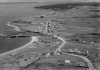
Noel is a community in the Canadian province of Nova Scotia, located in the Municipal District of East Hants, which is in Hants County, Nova Scotia. The community is most well known for being named after its most prominent resident Noël Doiron and for ship building in the nineteenth century. Noel Doiron is the namesake of the village as well as the surrounding communities of Noel Shore, Nova Scotia, East Noel, Noel Road, Nova Scotia, North Noel Road, Nova Scotia. The earliest recorded reference to the community of "Noel" was by surveyor Charles Morris in 1752. Prior to that date, the area is referred to as "Trejeptick", which first appears in the Colonial Office minutes of Annapolis Royal in 1734. Noel was also the home of the Osmond O'Brien Shipyard.

<span class="mw-page-title-main">Belliveau Cove, Nova Scotia</span>

Belliveau Cove is a historical Acadian community in the Canadian province of Nova Scotia, located in the District of Clare in Digby County settled in 1768 on un-ceded Mi'kmaq territory. A major centre of wooden shipbuilding in the 19th and early 20th century, Belliveau Cove built the second largest wooden ship ever constructed in Canada, the County of Yarmouth in 1884. It is now a mixed community of citizens with diverse backgrounds, including Acadians.

Noël Doiron was a leader of the Acadians, renowned for his leadership during the Deportation of the Acadians. Doiron was deported on a vessel named the Duke William (1758). The Duke William sank, killing many passengers, in one of the worst marine disasters in Canadian history. The captain of the Duke William, William Nichols, described Noel Doiron as the "father" to all the Acadians on Ile St. Jean and the "head prisoner" on board the ship.

<span class="mw-page-title-main">Bay of Fundy campaign</span> Campaign during the French and Indian War

The Bay of Fundy campaign occurred during the French and Indian War when the British ordered the Expulsion of the Acadians from Acadia after the Battle of Fort Beauséjour (1755). The campaign started at Chignecto and then quickly moved to Grand-Pré, Rivière-aux-Canards, Pisiguit, Cobequid, and finally Annapolis Royal. Approximately 7,000 Acadians were deported to the New England colonies.

<span class="mw-page-title-main">Acadian Exodus</span> Flight and Relocation of Acadians during Father Le Loutres War

The Acadian Exodus happened during Father Le Loutre's War (1749–1755) and involved almost half of the total Acadian population of Nova Scotia deciding to relocate to French controlled territories. The three primary destinations were: the west side of the Mesagoueche River in the Chignecto region, Isle Saint-Jean and Île-Royale. The leader of the Exodus was Father Jean-Louis Le Loutre, whom the British gave the code name "Moses". Le Loutre acted in conjunction with Governor of New France, Roland-Michel Barrin de La Galissonière, who encouraged the Acadian migration. A prominent Acadian who transported Acadians to Ile St. Jean and Ile Royal was Joseph-Nicolas Gautier. The overall upheaval of the early 1750s in Nova Scotia was unprecedented. Present-day Atlantic Canada witnessed more population movements, more fortification construction, and more troop allocations than ever before in the region. The greatest immigration of the Acadians between 1749 and 1755 took place in 1750. Primarily due to natural disasters and British raids, the Exodus proved to be unsustainable when Acadians tried to develop communities in the French territories.

<span class="mw-page-title-main">Cape d'Or</span> Lighthouse

Cape d'Or is a headland located near Advocate, Cumberland County, on the Bay of Fundy coast of the Canadian province of Nova Scotia.

References

  1. Shawn Scott and Tod Scott (2008). Noel Doiron and the East Hants Acadians. Royal Nova Scotia Historical Society: The Journal.
  2. "World's highest tides - Bay of Fundy". Bay of Fundy. Retrieved 2017-03-31.
  3. "Bay of Fundy Tides: The Highest Tides in the World!". www.bayoffundy.com. Retrieved 2017-03-31.
  4. "Bay of Fundy Tides: The Highest Tides in the World!". www.bayoffundy.com. Retrieved 2017-03-31.
  5. "Invertebrates - BURNTCOAT HEAD PARK". BURNTCOAT HEAD PARK. Retrieved 2017-03-31.
  6. "Invertebrates - BURNTCOAT HEAD PARK". BURNTCOAT HEAD PARK. Retrieved 2017-03-31.
  7. "Invertebrates - BURNTCOAT HEAD PARK". BURNTCOAT HEAD PARK. Retrieved 2017-03-31.
  8. "Shorelife - BURNTCOAT HEAD PARK". BURNTCOAT HEAD PARK. Retrieved 2017-03-31.
  9. "Shoreline Birds - BURNTCOAT HEAD PARK". BURNTCOAT HEAD PARK. Retrieved 2017-03-31.
  10. "Ocean Floor Adventures - BURNTCOAT HEAD PARK". BURNTCOAT HEAD PARK. Retrieved 2017-03-31.
  11. "44 Geologically Significant Sites in Nova Scotia - Bay of Fundy". www.bayoffundy.com. Retrieved 2017-03-31.
  12. "Geology - BURNTCOAT HEAD PARK". BURNTCOAT HEAD PARK. Retrieved 2017-03-31.
  13. "Geology - BURNTCOAT HEAD PARK". BURNTCOAT HEAD PARK. Retrieved 2017-03-31.
  14. Shawn Scott and Tod Scott (2008). Noel Doiron and the East Hants Acadians. Royal Nova Scotia Historical Society: The Journal.
  15. Pavone, Karen. "Robert Faulkner 1733". Geni. Geni.com. Retrieved 21 December 2020.
  16. John Duncanson. Rawdon and Douglas: Two Loyalist Townships in Nova Scotia. 1989, p. 184
  17. The Hants Journal, Oct 7, 1931
  18. "Lighthouses - BURNTCOAT HEAD PARK". BURNTCOAT HEAD PARK. Retrieved 2017-03-31.
  19. "Burntcoat Head". www.nslps.com. Retrieved 2017-03-31.

45°18′26.5″N63°48′30.7″W / 45.307361°N 63.808528°W / 45.307361; -63.808528