
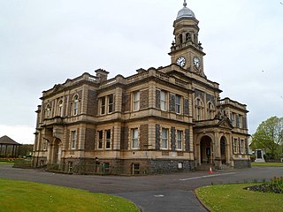
Carmarthenshire is a county in the south-west of Wales. The three largest towns are Llanelli, Carmarthen and Ammanford. Carmarthen is the county town and administrative centre. The county is known as the "Garden of Wales" and is also home to the National Botanic Garden of Wales.
Llanelli is a market town and community in Carmarthenshire and the preserved county of Dyfed, Wales. It is located on the Loughor estuary and is also the largest town in the county of Carmarthenshire.

Burry Port is a port town and community in Carmarthenshire, Wales, on the Loughor estuary, to the west of Llanelli and south-east of Kidwelly. Its population was recorded at 5,680 in the 2001 census and 6,156 in the 2011 census, and estimated at 5,998 in 2019. The town has a harbour. It is also where Amelia Earhart landed as the first woman to fly across the Atlantic Ocean. Nearby are the Pembrey Burrows sand dune and wetland system, forming a country park, and the Cefn Sidan sands. Its musical heritage includes Burry Port Opera, Male Choir and Burry Port Town Band.

Kidwelly is a town and community in Carmarthenshire, southwest Wales, approximately 7 miles (11 km) northwest of the most populous town in the county, Llanelli. In the 2001 census the community of Kidwelly returned a population of 3,289, increasing to 3,523 at the 2011 Census.
Pembrey Burrows stretch from Burry Port's harbour area – a former coal port, now a marina – to Pembrey Country Park, a leisure and nature complex that is one of West Wales's leading visitor attractions.

Cefn Sidan is a long sandy beach with dunes, which form the outer edge of the Pembrey Burrows between Burry Port and Kidwelly, facing southwestwards over Carmarthen Bay in South Wales. Cefn Sidan beach is backed by dunes, salt marshes, Pembrey Forest and the Pembrey Country Park.

Pembrey is a village in Carmarthenshire, Wales, situated between Burry Port and Kidwelly, overlooking Carmarthen Bay, with a population of about 2,154 in 2011. The electoral ward having a population of 4,301. It is in the community of Pembrey and Burry Port Town.

Llanelli is a constituency of the House of Commons of the Parliament of the United Kingdom. From 1918 to 1970 the official spelling of the constituency name was Llanelly. It elects one Member of Parliament (MP) by the first past the post system of election. Since 2005, it is currently represented by Nia Griffith of the Labour Party.

The West Wales lines are a group of railway lines from Swansea through Carmarthenshire to Pembrokeshire, West Wales. The main part runs from Swansea to Carmarthen and Whitland, where it becomes three branches to Fishguard, Milford Haven and Pembroke Dock.

Whiteford Point Lighthouse is located off the coast at Whiteford Point near Whiteford Sands, on the Gower Peninsula, South Wales.

Trimsaran is a community and former mining village which lies on the B4308 between Llanelli and Kidwelly, in Carmarthenshire, Wales.

The Kidwelly and Llanelly Canal was a canal and tramroad system in Carmarthenshire, Wales, built to carry anthracite coal to the coast for onward transportation by coastal ships. It began life as Kymer's Canal in 1766, which linked pits at Pwll y Llygod to a dock near Kidwelly. Access to the dock gradually became more difficult as the estuary silted up, and an extension to Llanelli was authorised in 1812. Progress was slow, and the new canal was linked to a harbour at Pembrey built by Thomas Gaunt in the 1820s, until the company's own harbour at Burry Port was completed in 1832. Tramways served a number of collieries to the east of Burry Port.

Pembrey and Burry Port Town is a community located in Carmarthenshire, Wales including the town of Burry Port and the village of Pembrey. The community population taken at the 2011 census was 8,547.

Court Farm in Pembrey, Carmarthenshire, Wales, is an ancient and formerly imposing manor house which is now an overgrown ruin, but structurally sound, and capable of repair and restoration. It consists of three buildings: the farmhouse, a complex two-storey house of approximately 99 square metres; an adjacent barn; and a later cowshed.

Burry Port Lifeboat Station was first opened in 1887, the cost of the station defrayed from a legacy bequeathed by the late Mrs J. S. Barclay of Edmonton, London, and in accordance with her wishes, the boat was named David Barclay of Tottenham (ON110), after her late husband.

The Portland Breakwater Lighthouse is a functioning lighthouse located at Portland Harbour, Isle of Portland, Dorset, England. It is situated on the southern end of the north-east breakwater.
Burry Port is an electoral ward, representing the community of Burry Port, Carmarthenshire, Wales.
Burry Port railway station served the town of Burry Port. It continued to serve the inhabitants of the area near Llanelli between 1909 and 1953 and was one of several basic halts opened on the Burry Port and Gwendraeth Valley Railway in Carmarthenshire, Wales.
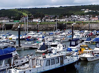
Burry Port Harbour is a former industrial harbour which mainly served the coal industry, on the Loughor estuary. It is now converted into a marina. The town of Burry Port grew around the harbour.


