
Maesteg is a town and community in Bridgend County Borough, Wales. Maesteg lies at the northernmost end of the Llynfi Valley, close to the border with Neath Port Talbot. In 2011, Maesteg had a population of 20,612. The English translation of Maesteg is 'fair field'.

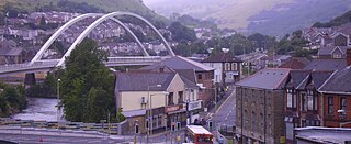
Burry Port is a port town and community in Carmarthenshire, Wales, on the Loughor estuary, to the west of Llanelli and south-east of Kidwelly. Its population was recorded at 5,680 in the 2001 census and 6,156 in the 2011 census, and estimated at 5,998 in 2019. The town has a harbour. It is also where Amelia Earhart landed as the first woman to fly across the Atlantic Ocean. Nearby are the Pembrey Burrows sand dune and wetland system, forming a country park, and the Cefn Sidan sands. Its musical heritage includes Burry Port Opera, Male Choir and Burry Port Town Band.
Porth is a town and a community in the county borough of Rhondda Cynon Taf, within the historic county boundaries of Glamorgan, Wales. Lying in the Rhondda Valley, it is regarded as the gateway connecting the Rhondda Fawr and Rhondda Fach valleys due to both valleys meeting at Porth. The Welsh word "porth" means "gate". Porth is a predominantly English-speaking community.
Mountain Ash is a town and former community in the Cynon Valley, within the County Borough of Rhondda Cynon Taf, Wales, with a population of 11,230 at the 2011 Census, estimated in 2019 at 11,339. It includes the districts and villages of Cefnpennar, Cwmpennar, Caegarw, Darranlas, Fernhill, Glenboi and Newtown, all within the historic county boundaries of Glamorgan. Aberdare lies about 4.5 miles (7.2 km) north-west, Cardiff 19 miles (31 km) south-east, and Penrhiwceiber a mile to the south-east. It divides into two communities : West covers the town centre and the districts of Miskin, Darranlas, Fernhill and Glenboi, and East the districts of Cefnpennar, Cwmpennar, Caegarw and Newtown.

Ynysybwl is a village in Cwm Clydach in Wales. It is situated in the county borough of Rhondda Cynon Taf, roughly 15 miles (24 km) north-north-west of Cardiff, 4 miles (6 km) north of Pontypridd and 16 miles (26 km) south of Merthyr Tydfil, and forms part of the community of Ynysybwl and Coed-y-Cwm.
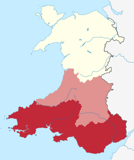
South Wales is a loosely defined region of Wales bordered by England to the east and mid Wales to the north. It has a population of around 2.2 million, almost three-quarters of the whole of Wales, including 400,000 in Cardiff, 250,000 in Swansea and 150,000 in Newport. Generally considered to include the historic counties of Glamorgan and Monmouthshire, south Wales extends westwards to include Carmarthenshire and Pembrokeshire. In the western extent, from Swansea westwards, local people would probably recognise that they lived in both south Wales and west Wales. The Brecon Beacons National Park covers about a third of south Wales, containing Pen y Fan, the highest British mountain south of Cadair Idris in Snowdonia.

Cwmdare is a village very close to Aberdare, in Rhondda Cynon Taf, Wales. The village's history is intertwined with coal-mining, and since the decline of the industry in the 1980s, it has become primarily a commuter base for the larger surrounding towns of Aberdare and Merthyr Tydfil and Pontypridd, as well as the cities of Cardiff and Swansea.

Rhigos is a small village on the saddle of higher ground between the Vale of Neath and the Cynon Valley. It was part of the old Neath Rural district Council under Glamorgan until 1974. The village then came under the jurisdiction of The Cynon Valley Borough which subsequently became Rhondda Cynon Taf, South Wales in 1996. It lies just off the old Aberdare road that was the main link between Aberdare and Glynneath, before the A465 road was extended in the 1960s. The hamlets of Cefn Rhigos and Cwm-Hwnt lie to the west of the main village.

Garnant is a Welsh mining village in the valley of the River Amman in Carmarthenshire, north of Swansea. Like the neighbouring village of Glanamman it experienced a coal-mining boom in the 19th and early 20th centuries, but the last big colliery closed in 1936 and coal has been extracted fitfully since then. The village has the only Commissioners' church built in southwest Wales, traditionally a Methodist region.

The River Gwendraeth is a river in Carmarthenshire in West Wales.
Trimsaran is a community and former mining village which lies on the B4308 between Llanelli and Kidwelly, in the Welsh county of Carmarthenshire.
Pontyates is a village straddling two communities situated in the Gwendraeth Valley halfway between Carmarthen and Llanelli in Carmarthenshire, West Wales. the population in 2011 was 1,449.

The Kidwelly and Llanelly Canal was a canal and tramroad system in Carmarthenshire, Wales, built to carry anthracite coal to the coast for onward transportation by coastal ships. It began life as Kymer's Canal in 1766, which linked pits at Pwll y Llygod to a dock near Kidwelly. Access to the dock gradually became more difficult as the estuary silted up, and an extension to Llanelli was authorised in 1812. Progress was slow, and the new canal was linked to a harbour at Pembrey built by Thomas Gaunt in the 1820s, until the company's own harbour at Burry Port was completed in 1832. Tramways served a number of collieries to the east of Burry Port.
Ysgol y Gwendraeth was a secondary comprehensive school for pupils aged 11 to 18 in the Gwendraeth Valley, Carmarthenshire, Wales. Situated in the village of Drefach, it had 312 pupils in 2012. The School was effectively closed in 2013 when it was merged with Ysgol Maes Yr Yrfa and teaching at the Ysgol y Gwendraeth site in Drefach ceased.
Ffairfach is a village one-half mile (0.80 km) south of the market town of Llandeilo in the eastern part of Carmarthenshire, Wales. It is located close to the confluence of the Afon Cennen and the River Towy. Population is 516 according to 2017 census.
Cynheidre Colliery was a coal mine located in the Gwendraeth valley, in Carmarthenshire, South Wales. Opened in 1954, it closed in 1989.
Pentremawr Colliery was a coal mine, located in the Gwendraeth valley in Carmarthenshire, South Wales.

Cwm is a former coal mining village, community and electoral ward three miles (4.8 km) south of Ebbw Vale in the county borough of Blaenau Gwent, Wales, within the historic boundaries of Monmouthshire, United Kingdom. In the far north of the community lies Waunlwyd.
Ponthenry railway station was opened in 1909 It continued to serve the inhabitants of the Pont-henri area and hinterland between 1909 and 1953; it was one of several basic stations opened on the Burry Port and Gwendraeth Valley Railway in Carmarthenshire, Wales.
Pontyberem railway station was opened in 1909 to timetabled passenger services however services for miners began in 1898. It continued to serve the inhabitants of the Pontyberem area and hinterland between 1909 and 1953; it was one of several basic stations opened on the Burry Port and Gwendraeth Valley Railway in Carmarthenshire, Wales.

