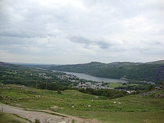
Llanberis is a village, community and electoral ward in Gwynedd, northwest Wales, on the southern bank of the lake Llyn Padarn and at the foot of Snowdon, the highest mountain in Wales. It is a centre for outdoor activities in Snowdonia, including walking, mountaineering, climbing, mountain biking and pony trekking, as well as water sports such as scuba diving. The community includes Nant Peris.

Newcastle Emlyn is a town on the River Teifi, straddling the counties of Ceredigion and Carmarthenshire in West Wales. It is also a community entirely within Carmarthenshire, bordered by those of Llangeler and Cenarth, also in Carmarthenshire, and by Llandyfriog in Ceredigion. Adpar is the part of town on the Ceredigion side of the River Teifi. It was formerly called Trefhedyn and was an ancient Welsh borough in its own right. The area including Adpar had a population of 1,883 according to the 2011 census.

Llandybie is a village and community which includes a large village of the same name situated 2 miles (3.2 km) north of Ammanford in Carmarthenshire, Wales.

Felinfoel is a small village and electoral ward on the River Lliedi on the northern border of Llanelli, Carmarthenshire, West Wales, with a population of about 2,000.

Llangadog railway station serves the village of Llangadog near Llandeilo, Carmarthenshire. The station is on the Heart of Wales Line 36+1⁄2 miles (59 km) north east of Swansea. The station is located at street level at Station Road beside the River Brân. The Garn Goch Iron Age hill fort is about three miles away from this station.

Llangyndeyrn is a village, community and electoral ward in the River Gwendraeth valley, Carmarthenshire, in Dyfed region of West Wales, United Kingdom. The village name is often spelt as Llangendeirne.

Llanllyfni is a village and a community in Gwynedd, Wales. It is in the historic county of Caernarfonshire. The community consists of the villages of Drws-y-coed, Nantlle, Nasareth, Nebo, Penygroes, Talysarn and the village of Llanllyfni itself. Penygroes, Llanllyfni and Talysarn are almost conjoined. As an electoral ward the 2011 census recorded a population of 1256. It is a largely Welsh-speaking village as 85% of the villagers speak Welsh as their first language. The community covers 43 square kilometres.

Llanboidy is a village and community in Carmarthenshire, West Wales. The community includes the village of Llanglydwen.

Llanpumsaint is a village and community in Carmarthenshire, Wales. In the 2001 UK Census, Llanpumsaint community had a population of 595. It is not to be confused with Pumsaint, a small village some distance away on the River Cothi. The population increased in 2011 to 734, and thus the percentage of Welsh speakers declined.

Tremeirchion is a small residential community in Denbighshire, Wales. It lies on the B5429 road, to the north east of Denbigh and to the east of St Asaph. The community includes the village of Rhuallt.

Cynwyl Elfed is a village and community in the county of Carmarthenshire, Wales. The community includes the villages of Cynwyl Elfed, Blaenycoed and Cwmduad. It is situated about 5 miles (8.0 km) north of Carmarthen and had a population of 953 in 2001, increasing to 1,044 at the 2011 Census.
Llanddeusant is a community in the Black Mountain Range of the Brecon Beacons National Park in Carmarthenshire, Wales. It is about 5 miles southeast of Llangadog.
Manordeilo and Salem is a community located in Carmarthenshire, Wales. The population taken at the 2011 census was 1,754.
Quarter Bach is a community located in the east of Carmarthenshire, Wales.

Llanrug is a medium-sized village and community in Gwynedd, north-west Wales. It lies about 4 miles (6.4 km) to the east of Caernarfon, 7 miles (11 km) south of Bangor and 3 miles (4.8 km) northwest of Llanberis. It is the largest populated village in the Arfon area of Gwynedd, Wales. The old name of the village was Llanfihangel-y-Rug, derived from Eglwys Sant Mihangel, which is situated about half a mile west of the village.

Bethel is a village in Gwynedd, Wales. It lies east of Caernarfon on the B4366 road. Bethel Primary School is located in the village. The population of Bethel electoral ward was measured in the 2011 Census, and found to be 1,395. The village population is 1,171 with 87.3% having some form of Welsh identity one of the highest figures in the north of Wales.
Ffairfach is a village one-half mile (0.80 km) south of the market town of Llandeilo in the eastern part of Carmarthenshire, Wales. It is located close to the confluence of the Afon Cennen and the River Towy. Population is 516 according to 2017 census.

Llandissilio is a village and parish in the community of Llandissilio West in east Pembrokeshire, Wales on the A478 road between Efailwen to the north and Clunderwen to the south. A largely ribbon development along the main road, the village is surrounded by farmland.

Gwynfe or Capel Gwynfe is a small village inside the portion of Brecon Beacons National Park that is in Carmarthenshire, a county of southwestern Wales. This village is situated between Trichrug and the western slopes of the Black Mountain, to the west of the A4069 road about halfway between Llangadog and Brynamman. The village comprises a scattered collection of mostly nineteenth and twentieth-century housing that developed around several chapels. The area around the village is mainly farmland and the village was 2004 'Village of the Year for Carmarthenshire'. The village has a grade-two listed phone box now used as an information centre and a modern community hall built in 2001. The community association have erected 2 large woodcarvings of three red kites.


