
Mukono is one of the districts in the Central Region of Uganda. The town of Mukono home to the district's main commercial center and district headquarters.

Wakiso District is a district in the Central Region of Uganda that partly encircles Kampala, Uganda's capital city. The town of Wakiso is the site of the district headquarters. Kira, the country's second largest city and suburb of Kampala, is in the district.

The Mandela National Stadium is a multi-purpose stadium in Uganda. It is named after the South African then-President and anti-apartheid icon, Nelson Mandela. The stadium's record attendance of 50,000 was set in 2004, in a football match between the national football teams of Uganda and South Africa.
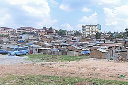
Kira Town, a municipality in the Wakiso District of the Central Region of Uganda, is the country's second-largest city by population. It is administered by the Kira Town Council, an urban local government.

Mukono Town is a municipality in Mukono District in the Central Region of Uganda. The town is administered by the Mukono Town Council. The district headquarters are located in this town.
Wakiso is a city in the Central Region of Uganda. It is the headquarters of Wakiso District.
Lugazi is a town in the Buikwe District of the Central Region of Uganda. The town is also called "Kawolo", and the two names are interchangeably used by the local inhabitants.
The Kampala–Jinja Highway is a road in Uganda, connecting the cities of Kampala and Jinja. Sometimes referred to as Kampala–Jinja Road, it is a busy road, with several towns, trading centers and other points of interest along the way. As of October 2016, a new, wider, four-lane dual carriageway expressway, the Kampala–Jinja Expressway, is proposed to be constructed south of the present highway to relieve traffic and complement existing transport infrastructure between Kampala and Jinja.
Nansana is a town in the Central Region of Uganda. It is located in the Wakiso District and is one of the five municipalities in the district.Nansana is a municipal council comprising four Divisions; Nansana Division, Nabweru Division, Gombe Division, and Busukuma Divisions. The four Divisions are considered as lower local government independent units.
Kireka is the name of a township in Central Uganda. It is one of the six townships or Wards that constitute Kira Municipality in Wakiso District. The other five Wards in Kira Municipality are Bweyogerere Ward, Kimwaanyi Ward, Kira Ward, Kirinnya Ward and Kyaliwajjala Ward.
Nsasa is a neighborhood in Kira Municipality, Kyaddondo County, Wakiso District, in the Central Region of Uganda.

Kajjansi is a town in Central Uganda. It is one of the urban centers in Wakiso District.
Naalya is a township in Kira Municipality, in Kyaddondo County, Wakiso District, in Uganda.
Namanve is an area in the Central Region of Uganda. The larger portion of Namanve lies in Kira Municipality, in Wakiso District with portions located in Mukono Municipality, in Mukono District.
Kyaliwajjala is a neighborhood in Kira Municipality, Kyaddondo County, Wakiso District, in Central Uganda.
Kimwanyi is a neighborhood in Kira Municipality, Wakiso District, in the Buganda Region of Uganda. Kimwanyi also refers to Kimwanyi Parish, in Kira sub-county, Kyaddondo County, Wakiso District. It is one of the six parishes (wards) of Kira Municicipality, namely; Kimwanyi, Kira, Kyaliwajjala, Kireka, Bweyogerere and Kirinnya.
The Kampala Southern Bypass Highway is a proposed four-lane, dual carriage highway in the Central Region of Uganda, connecting, Bweyogerere, in the Wakiso District, to Munyonyo in the Makindye Division of Kampala, the largest city and capital of Uganda.
Upper Mulago Regional Referral Hospital, also known as Old Mulago Regional Referral Hospital, is a planned hospital in Uganda. When established, it is expected to serve as the regional referral hospital for the Kampala Metropolitan Area, which includes the capital city of Kampala and the surrounding Wakiso District.
Mbalwa is a neighborhood in Kyaliwajjala Parish, Kira Municipality, Wakiso District in the Central Region of Uganda.
Kijabijo is a neighborhood in Kira Town, in Wakiso District in the Buganda Region of Uganda.

