
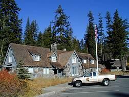
Mineral King is a subalpine glacial valley located in the southern part of Sequoia National Park, in the U.S. state of California. The valley lies at the headwaters of the East Fork of the Kaweah River, which rises at the eastern part of the valley and flows northwest. Accessed by a long and narrow winding road, the valley is mostly popular with backpackers and hikers.

Scenic State Park is a Minnesota state park near Bigfork in Itasca County. It encompasses 3,936 acres (1,593 ha) of virgin pine forests that surround Sandwick Lake and Coon Lake. It also includes portions of Lake of the Isles, Tell Lake, Cedar Lake, and Pine Lake. Established in 1921, the Ojibwe tribe had previously used the area for hunting. The park has places for camping, hiking, swimming, fishing, and canoeing.

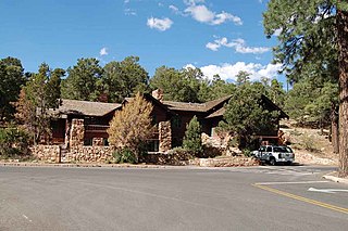
Grand Canyon Village Historic District comprises the historic center of Grand Canyon Village, on the South Rim of the Grand Canyon in Grand Canyon National Park, Arizona. The district includes numerous landmark park structures, many of which are National Historic Landmarks themselves, or are listed on the National Register of Historic Places. The town design as a whole is also significant for its attention to integration with the Grand Canyon landscape, its incorporation of National Park Service Rustic design elements, and for the idiosyncratic design of park concessioner structures such as the El Tovar Hotel.
Munson Valley Historic District is the headquarters and main support area for Crater Lake National Park in southern Oregon. The National Park Service chose Munson Valley for the park headquarters because of its central location within the park. Because of the unique rustic architecture of the Munson Valley buildings and the surrounding park landscape, the area was listed as a historic district on the National Register of Historic Places (NRHP) in 1988. The district has eighteen contributing buildings, including the Crater Lake Superintendent's Residence which is a U.S. National Historic Landmark and separately listed on the NRHP. The district's NRHP listing was decreased in area in 1997.

Oregon Caves Historic District covers 6 acres (24,000 m2) in the main visitor area of Oregon Caves National Monument in southern Oregon. The district includes four primary buildings plus two other structures. Because of the unique rustic architecture of these National Park Service buildings and the surrounding park landscape, the area was listed on the National Register of Historic Places in 1992.

The Clackamas Lake Ranger Station Historic District is a Forest Service compound consisting of eleven historic buildings located in the Mount Hood National Forest in the Cascade Mountains of northern Oregon. It was originally built as a district ranger station for the Clackamas Lake Ranger District. It was later converted to a summer guard station. Today, the Forest Service rents the historic ranger's residence to recreational visitors. The Clackamas Lake Ranger Station is listed as a historic district on the National Register of Historic Places.

The Ash Mountain Entrance Sign at Sequoia National Park was constructed in 1935 by Civilian Conservation Corps craftsmen. Featuring a carved Native American face, the sign was made from blocks of sequoia wood and fastened with wrought iron brackets.

The Giant Forest Village–Camp Kaweah Historic District is located in Sequoia National Park. It is notable as one of two registered historic districts in the park that were largely demolished as part of National Park Service efforts to mitigate the impact of park visitor facilities on the park's giant sequoia groves. They were in a vernacular National Park Service Rustic and American Craftsman Bungalow style.

The Merced Grove Ranger Station in Yosemite National Park was designed by the National Park Service and completed in 1935. An example of the National Park Service Rustic style, it features log construction. The station is near the Merced Grove of giant sequoias, in the Crane Flat region of the park.

The Saddlehorn Caretaker's House and Garage, also known as the Stone House, the Rock House, and the Superintendent's Quarters is a house and asset listed as part of the National Register of Historic Places located in the Colorado National Monument.

The historical buildings and structures of Zion National Park represent a variety of buildings, interpretive structures, signs and infrastructure associated with the National Park Service's operations in Zion National Park, Utah. Structures vary in size and scale from the Zion Lodge to road culverts and curbs, nearly all of which were designed using native materials and regional construction techniques in an adapted version of the National Park Service Rustic style. A number of the larger structures were designed by Gilbert Stanley Underwood, while many of the smaller structures were designed or coordinated with the National Park Service Branch of Plans and Designs. The bulk of the historic structures date to the 1920s and 1930s. Most of the structures of the 1930s were built using Civilian Conservation Corps labor.

The Wonderland Trail is an approximately 93-mile (150 km) hiking trail that circumnavigates Mount Rainier in Mount Rainier National Park, Washington, United States. The trail goes over many ridges of Mount Rainier for a cumulative 22,000 feet (6,700 m) of elevation gain. The trail was built in 1915.

The historical buildings and structures of Grand Teton National Park include a variety of buildings and built remains that pre-date the establishment of Grand Teton National Park, together with facilities built by the National Park Service to serve park visitors. Many of these places and structures have been placed on the National Register of Historic Places. The pre-Park Service structures include homestead cabins from the earliest settlement of Jackson Hole, working ranches that once covered the valley floor, and dude ranches or guest ranches that catered to the tourist trade that grew up in the 1920s and 1930s, before the park was expanded to encompass nearly all of Jackson Hole. Many of these were incorporated into the park to serve as Park Service personnel housing, or were razed to restore the landscape to a natural appearance. Others continued to function as inholdings under a life estate in which their former owners could continue to use and occupy the property until their death. Other buildings, built in the mountains after the initial establishment of the park in 1929, or in the valley after the park was expanded in 1950, were built by the Park Service to serve park visitors, frequently employing the National Park Service Rustic style of design.

Canelo Ranger Station, also known as Canelo Work Station, is a historic ranger station in the Coronado National Forest, within Santa Cruz County of southern Arizona. It is located in the ghost town of Canelo, within a small valley between the Canelo Hills on the west and the northern Huachuca Mountains on the east.
Daniel Ray Hull (1890–1964), sometimes stated Daniel P. Hull, was an American landscape architect who was responsible for much of the early planning of the built environment the national parks of the United States during the 1920s. Hull planned town sites, designed landscapes, and designed individual buildings for the Park Service, in private practice, and later for the California State Parks. A number of his works are listed on the U.S. National Register of Historic Places.

The Gasquet Ranger Station Historic District comprises a compound of buildings associated with the Gasquet Ranger District of Six Rivers National Forest. The U.S. Forest Service complex is located along the Smith River on U.S. Route 199 in Del Norte County, California, within Smith River National Recreation Area. Most of the buildings were built by the Civilian Conservation Corps between 1933 and 1939. Seven buildings and a rock wall remain of the CCC-built structures. The district office, the assistant district ranger's residence, a warehouse, two garages and a fuel house were built in the Forest Service rustic style that prevailed at the time. The style is reflected in distinctive detailing, including a recurring pine tree cut-out logo that appears on gables and shutters.

The Gold Creek Ranger Station is located in Humboldt-Toiyabe National Forest in Elko County, Nevada, USA. It was built in 1910 to administer the Ruby Mountains Forest Reserve, which became Humboldt National Forest. The compound was later expanded by labor provided by the Civilian Conservation Corps.
Architects of the National Park Service are the architects and landscape architects who were employed by the National Park Service (NPS) starting in 1918 to design buildings, structures, roads, trails and other features in the United States National Parks. Many of their works are listed on the National Register of Historic Places, and a number have also been designated as National Historic Landmarks.
Harold G. Fowler was a National Park Service landscape architect.

The Kabetogama Ranger Station District is a historic ranger station complex in Kabetogama, Minnesota, United States. It was built from 1933 to 1941 by the Civilian Conservation Corps (CCC) as an administrative center for Kabetogama State Forest, managed by the Minnesota Department of Natural Resources. Following the establishment of Voyageurs National Park in the 1970s, the Minnesota government finalized the donation of the property to the National Park Service (NPS) in 1987. The NPS continues to use the property as one of the four administrative and visitor entrances to Voyageurs.


