
Flamingo is the southernmost headquarters of Everglades National Park, in Monroe County, Florida, United States. Flamingo is one of the two end points of the 99-mile (159-km) Wilderness Waterway, and the southern end of the only road through the park from Florida City. It began as a small coastal settlement on the eastern end of Cape Sable on the southern tip of the Florida peninsula, facing Florida Bay. The actual town of Flamingo was located approximately 4+1⁄2 miles west of the current Flamingo campground area. All that remains of the former town are a few remnants of building foundations, and it is considered a ghost town.

Prince William Forest Park is a national park in the U.S. state of Virginia within Prince William County, located adjacent to the Marine Corps Base Quantico near the town of Dumfries. Established as Chopawamsic Recreational Demonstration Area in 1936, the park is the largest protected natural area in the Washington, D.C. metropolitan region at over 13,000 acres (5,300 ha).
The Generals Highway is a highway that connects State Route 180 and State Route 198 through Sequoia National Park, Sequoia National Forest, Giant Sequoia National Monument, and Kings Canyon National Park in the Sierra Nevada of California. As the road goes through national parks and monuments, the highway is primarily maintained by the federal government instead of a California State Highway controlled by Caltrans.

Mineral King is a subalpine glacial valley located in the southern part of Sequoia National Park, in the U.S. state of California. The valley lies at the headwaters of the East Fork of the Kaweah River, which rises at the eastern part of the valley and flows northwest. Accessed by a long and narrow winding road, the valley is mostly popular with backpackers and hikers.

The Kaweah Colony was a utopian socialist community in central California founded in 1886, with a name meaning "here we rest." Located in the Sierra Nevada range, they lived near groves of giant sequoia trees. The colony officially disbanded in 1892. The establishment of Sequoia National Park in 1890 contributed to the colony's demise. Some of their descendants still reside in the area.

The Kaweah River is a river draining the southern Sierra Nevada in Tulare County, California in the United States. Fed primarily by high elevation snowmelt along the Great Western Divide, the Kaweah begins as four forks in Sequoia National Park, where the watershed is noted for its alpine scenery and its dense concentrations of giant sequoias, the largest trees on Earth. It then flows in a southwest direction to Lake Kaweah – the only major reservoir on the river – and into the San Joaquin Valley, where it diverges into multiple channels across an alluvial plain around Visalia. With its Middle Fork headwaters starting at almost 13,000 feet (4,000 m) above sea level, the river has a vertical drop of nearly two and a half miles (4.0 km) on its short run to the San Joaquin Valley, making it one of the steepest river drainages in the United States. Although the main stem of the Kaweah is only 33.6 miles (54.1 km) long, its total length including headwaters and lower branches is nearly 100 miles (160 km).

The Giant Forest, famed for its giant sequoia trees, is within the United States' Sequoia National Park. This montane forest, situated at over 6,000 ft (1,800 m) above mean sea level in the western Sierra Nevada of California, covers an area of 1,880 acres (7.6 km2). The Giant Forest is the most accessible of all giant sequoia groves, as it has over 40 mi (64 km) of hiking trails.
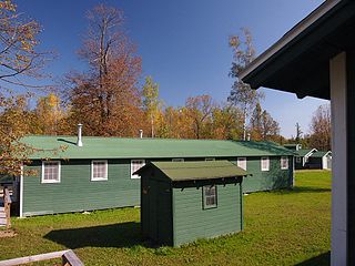
The Rabideau CCC Camp was a Civilian Conservation Corps (CCC) camp in the Chippewa National Forest in northern Minnesota, United States. It is located off Beltrami County Highway 39, in Taylor Township, and is one of the best-preserved of the nation's many CCC camps. A National Historic Landmark, it now serves as an educational center.

Mansfield Plantation is a well-preserved antebellum rice plantation, established in 1718 on the banks of the Black River in historic Georgetown County, South Carolina.

Old Faithful Lodge in Yellowstone National Park is located opposite the more famous Old Faithful Inn, facing Old Faithful geyser. The Lodge was built as a series of detached buildings through 1923 and was consolidated into one complex by architect Gilbert Stanley Underwood in 1926-27. The Lodge is included in the Old Faithful Historic District.

The Roosevelt Lodge Historic District comprises the area around the Roosevelt Lodge in the northern part of Yellowstone National Park, near Tower Junction. The district includes 143 buildings ranging in size from cabins to the Lodge, built beginning in 1919. The Lodge was first conceived as a field laboratory for students and educators conducting research in the park. It later became a camp for tourists, specifically designed to accommodate automobile-borne tourists. The Lodge is a simplified version of the National Park Service Rustic style.

The Mammoth Hot Springs Historic District is a 158-acre (64 ha) historic district in Yellowstone National Park comprising the administrative center for the park. It is composed of two major parts: Fort Yellowstone, the military administrative center between 1886 and 1918, and now a National Historic Landmark, and a concessions district which provides food, shopping, services, and lodging for park visitors and employees. It was added to the National Register of Historic Places on March 20, 2002, for its significance in architecture, conservation, entertainment/recreation, and military. The district includes 189 contributing buildings.

The Bar B C Dude Ranch was established near Moose, Wyoming in 1912 as a dude ranch by Struthers Burt and Dr. Horace Carncross, using their initials as the brand. Rather than converting a working ranch, Burt and Carncross built a tourist-oriented dude ranch from the ground up, using a style called "Dude Ranch Vernacular", which featured log construction and rustic detailing. As one of the first dude ranches in Jackson Hole, the Bar B C was a strong influence on other dude ranches in the area, and employed a number of people who went on to establish their own operations. It was acquired by the National Park Service and incorporated into Grand Teton National Park upon the expiration of a life estate. The ranch was listed on the National Register of Historic Places in 1990.

The Geraldine Lucas–Fabian Place Historic District in Jackson Hole, Wyoming is significant as the 1913 home of Geraldine Lucas, a single woman pioneer in a harsh environment. It later became the home of Harold Fabian, vice president of the Snake River Land Company, which assembled much of the land that became Jackson Hole National Monument for John D. Rockefeller Jr.

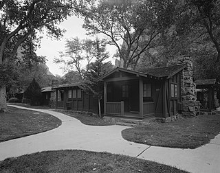
The Giant Forest Village–Camp Kaweah Historic District is located in Sequoia National Park. It is notable as one of two registered historic districts in the park that were largely demolished as part of National Park Service efforts to mitigate the impact of park visitor facilities on the park's giant sequoia groves. They were in a vernacular National Park Service Rustic and American Craftsman Bungalow style.
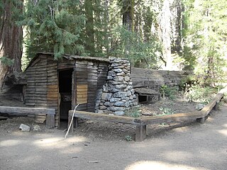
Tharp's Log is a hollowed giant sequoia log at Log Meadow in the Giant Forest grove of Sequoia National Park that was used as a shelter by early pioneers. The log is named after Hale D. Tharp, who was described as the first Non-Native American to enter the Giant Forest.

The Generals' Highway Stone Bridges, built in 1930, are part of the Generals' Highway from the General Grant Grove of giant sequoias in Kings Canyon National Park through Sequoia National Park. One bridge spans the Marble Fork of the Kaweah River in a wooded setting, while the other, similar bridge spans Clover Creek in a bare canyon.

The Moraine Park Museum and Amphitheater, also known as the Moraine Park Lodge and the Moraine Park Visitor Center, are located in Moraine Park, a glaciated meadow between two moraines in Rocky Mountain National Park.
The Zion Lodge Historic District surrounds the rustic lodge originally designed by Gilbert Stanley Underwood in Zion National Park. The lodge served as the center of a group of cabins, employee dormitories and support buildings which are included in the district. A swimming pool and bathhouse were demolished in 1976. The district was expanded in 1986 to include an Underwood-designed former photography studio and additional cabins.
Wuksachi Village is a visitor services development in Sequoia National Park, California. It was developed to replace the Giant Forest-Camp Kaweah development, which was regarded as being much too close to sensitive giant sequoia groves. Wuksachi Village is about 5 miles (8.0 km) north of the Giant Forest. It was originally proposed in the 1971 park master plan as the "Clover Creek-Willow Meadow" development, incorporating campgrounds as well as lodgings. Over time the campground feature was dropped. By 1980 the Clover Creek site was approved for development. Work involved a new maintenance facility at Red Fir and improvements to the existing Lodgepole campsite. Work began on Wuksachi Village in 1985 to build employee accommodations, a fire station and water and wastewater treatment facilities. Guest accommodations were built by concessioner Delaware North, opening in June 1999. There are three lodging units with a total of 102 rooms, with potential expansion to 414 rooms. The lodge buildings were designed by Clayton B. Wardel.


