
Tuolumne Meadows is a gentle, dome-studded, sub-alpine meadow area along the Tuolumne River in the eastern section of Yosemite National Park in the United States. Its approximate location is 37°52.5′N119°21′W. Its approximate elevation is 8,619 feet (2,627 m). The term Tuolumne Meadows is also often used to describe a large portion of the Yosemite high country around the meadows, especially in context of rock climbing.

Kings Canyon National Park is an American national park in the southern Sierra Nevada, in Fresno and Tulare Counties, California. Originally established in 1890 as General Grant National Park, the park was greatly expanded and renamed on March 4, 1940. The park's namesake, Kings Canyon, is a rugged glacier-carved valley more than a mile (1,600 m) deep. Other natural features include multiple 14,000-foot (4,300 m) peaks, high mountain meadows, swift-flowing rivers, and some of the world's largest stands of giant sequoia trees. Kings Canyon is north of and contiguous with Sequoia National Park, and both parks are jointly administered by the National Park Service as the Sequoia and Kings Canyon National Parks.

Sequoia National Park is an American national park in the southern Sierra Nevada east of Visalia, California. The park was established on September 25, 1890, and today protects 404,064 acres of forested mountainous terrain. Encompassing a vertical relief of nearly 13,000 feet (4,000 m), the park contains the highest point in the contiguous United States, Mount Whitney, at 14,505 feet (4,421 m) above sea level. The park is south of, and contiguous with, Kings Canyon National Park; both parks are administered by the National Park Service together as the Sequoia and Kings Canyon National Parks. UNESCO designated the areas as Sequoia-Kings Canyon Biosphere Reserve in 1976.

Moro Rock is a granite dome rock formation in Sequoia National Park, California, United States. It is located in the center of the park, at the head of Moro Creek, between Giant Forest and Crescent Meadow. A stairway, designed by the National Park Service and built in 1931, is cut into and poured onto the rock, so that visitors can hike to the top. The view from the rock encompasses much of the Park, including the Great Western Divide. Use of this trail is discouraged during thunderstorms and when it is snowing.

Mineral King is a subalpine glacial valley located in the southern part of Sequoia National Park, in the U.S. state of California. The valley lies at the headwaters of the East Fork of the Kaweah River, which rises at the eastern part of the valley and flows northwest. Accessed by a long and narrow winding road, the valley is mostly popular with backpackers and hikers.

Grand Canyon Village Historic District comprises the historic center of Grand Canyon Village, on the South Rim of the Grand Canyon in Grand Canyon National Park, Arizona. The district includes numerous landmark park structures, many of which are National Historic Landmarks themselves, or are listed on the National Register of Historic Places. The town design as a whole is also significant for its attention to integration with the Grand Canyon landscape, its incorporation of National Park Service Rustic design elements, and for the idiosyncratic design of park concessioner structures such as the El Tovar Hotel.
The Moran Bay Patrol Cabin was built by the Civilian Conservation Corps about 1932. The log structure was located in the northern backcountry of Grand Teton National Park, and was built to a standard design for such structures, in the National Park Service Rustic style, but for the U.S. Forest Service, which administered much of the area prior to the expansion of the park in 1943. The Upper Granite Canyon Patrol Cabin is similar.

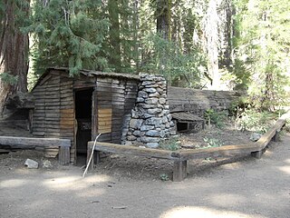
The Upper Granite Canyon Patrol Cabin was built by the Civilian Conservation Corps about 1935. The log structure is located in the extreme southwest backcountry of Grand Teton National Park. The cabin was built according to a standard design for such structures, in the National Park Service Rustic style. The Moran Bay Patrol Cabin is similar.

The Glacier National Park Tourist Trails, including the Inside Trail, South Circle Trail and North Circle Trail, were established in Glacier National Park to connect a series of tourist camps and hotels established by the Great Northern Railway between 1910 and 1915. Prior to the construction of the Going-to-the-Sun Road, these trails were the primary form of circulation within the park. The trail system includes a number of bridges.

The Pass Creek Snowshoe Cabin, built in 1938 in Glacier National Park, is a significant resource both architecturally and historically as a shelter, usually 8–12 miles (13–19 km) apart, for patrolling backcountry rangers.

The Faraway Ranch Historic District is part of the Chiricahua National Monument in southeastern Arizona, and preserves an area associated with the final conflicts with the local Apache, one of the last frontier settlements, and in particular, its association with the people who promoted the establishment of the Chiricahua National Monument. Faraway Ranch is located in Bonita Canyon, which lies at an approximate altitude of 5160 feet and opens in a southwesterly direction into the Sulphur Springs Valley.

The Lee's Ferry and Lonely Dell Ranch Historic District includes the ranch homesteaded by Mormon pioneer John D. Lee at Lees Ferry, Arizona, and now in Glen Canyon National Recreation Area. It is notable for its association with Lee, the ferry and the ranch's extensive irrigation facilities. The district was originally designated the Lonely Dell Ranch Historic District on the National Register of Historic Places in 1978, but was expanded to include Lee's Ferry in 1997.
Tharp's Log is a hollowed giant sequoia log at Log Meadow in the Giant Forest grove of Sequoia National Park that was used as a shelter by early pioneers. The log is named after Hale D. Tharp, who was described as the first Non-Native American to enter the Giant Forest.

The Barton–Lackey Cabin, also known as the Barton Cattle Camp and the Lackey Cattle Camp, was built in 1910 in the Roaring River Canyon of what became Kings Canyon National Park in California. The cabin was a shelter for stockmen using the summer range in the upper Kings River Canyon summer range, at an elevation of 7400 feet. The cabin was once surrounded by a significant number of outbuildings, which have all disappeared.

The Pear Lake Ski Hut is a mountain hut in Sequoia National Park, California, listed on the National Register of Historic Places. Built in Sequoia National Park by the Civilian Conservation Corps from 1939–41 using local Sierra granite and timber materials, the hut is an example of the National Park Service Rustic style, using rough masonry and a log roof structure.

The Moraine Park Museum and Amphitheater, also known as the Moraine Park Lodge and the Moraine Park Visitor Center, are located in Moraine Park, a glaciated meadow between two moraines in Rocky Mountain National Park.

The historical buildings and structures of Zion National Park represent a variety of buildings, interpretive structures, signs and infrastructure associated with the National Park Service's operations in Zion National Park, Utah. Structures vary in size and scale from the Zion Lodge to road culverts and curbs, nearly all of which were designed using native materials and regional construction techniques in an adapted version of the National Park Service Rustic style. A number of the larger structures were designed by Gilbert Stanley Underwood, while many of the smaller structures were designed or coordinated with the National Park Service Branch of Plans and Designs. The bulk of the historic structures date to the 1920s and 1930s. Most of the structures of the 1930s were built using Civilian Conservation Corps labor.

The historical buildings and structures of Grand Teton National Park include a variety of buildings and built remains that pre-date the establishment of Grand Teton National Park, together with facilities built by the National Park Service to serve park visitors. Many of these places and structures have been placed on the National Register of Historic Places. The pre-Park Service structures include homestead cabins from the earliest settlement of Jackson Hole, working ranches that once covered the valley floor, and dude ranches or guest ranches that catered to the tourist trade that grew up in the 1920s and 1930s, before the park was expanded to encompass nearly all of Jackson Hole. Many of these were incorporated into the park to serve as Park Service personnel housing, or were razed to restore the landscape to a natural appearance. Others continued to function as inholdings under a life estate in which their former owners could continue to use and occupy the property until their death. Other buildings, built in the mountains after the initial establishment of the park in 1929, or in the valley after the park was expanded in 1950, were built by the Park Service to serve park visitors, frequently employing the National Park Service Rustic style of design.

Wilsonia is a census-designated place (CDP) in Tulare County, California. Wilsonia sits at an elevation of 6,617 feet (2,017 m). It is surrounded by the General Grant Grove section of Kings Canyon National Park.
Architects of the National Park Service are the architects and landscape architects who were employed by the National Park Service (NPS) starting in 1918 to design buildings, structures, roads, trails and other features in the United States National Parks. Many of their works are listed on the National Register of Historic Places, and a number have also been designated as National Historic Landmarks.


