Grand Canyon National Park, located in northwestern Arizona, is the 15th site in the United States to have been named a national park. The park's central feature is the Grand Canyon, a gorge of the Colorado River, which is often considered one of the Wonders of the World. The park, which covers 1,217,262 acres of unincorporated area in Coconino and Mohave counties, received more than six million recreational visitors in 2017, which is the second highest count of all American national parks after Great Smoky Mountains National Park. The Grand Canyon was designated a World Heritage Site by UNESCO in 1979. The park celebrated its 100th anniversary on February 26, 2019.

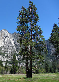
Yosemite National Park is an American national park located in the western Sierra Nevada of Central California, bounded on the southeast by Sierra National Forest and on the northwest by Stanislaus National Forest. The park is managed by the National Park Service and covers an area of 748,436 acres and sits in four counties: centered in Tuolumne and Mariposa, extending north and east to Mono and south to Madera County. Designated a World Heritage site in 1984, Yosemite is internationally recognized for its granite cliffs, waterfalls, clear streams, giant sequoia groves, lakes, mountains, meadows, glaciers, and biological diversity. Almost 95% of the park is designated wilderness.

Cedar Breaks National Monument is a U.S. National Monument located in the U.S. state of Utah near Cedar City. Cedar Breaks is a natural amphitheater, stretching across 3 miles (4.8 km), with a depth of over 2,000 feet (610 m). The elevation of the rim of the amphitheater is over 10,000 feet (3,000 m) above sea level.

Sequoia National Park is an American national park in the southern Sierra Nevada east of Visalia, California. The park was established on September 25, 1890 to protect 404,064 acres of forested mountainous terrain. Encompassing a vertical relief of nearly 13,000 feet (4,000 m), the park contains the highest point in the contiguous United States, Mount Whitney, at 14,505 feet (4,421 m) above sea level. The park is south of, and contiguous with, Kings Canyon National Park; the two parks are administered by the National Park Service together as the Sequoia and Kings Canyon National Parks. UNESCO designated the areas as Sequoia-Kings Canyon Biosphere Reserve in 1976.

The Kings River is a 132.9-mile (213.9 km) river draining the Sierra Nevada mountain range in central California in the United States. Its headwaters originate along the Sierra Crest in and around Kings Canyon National Park and form the eponymous Kings Canyon, one of the deepest river gorges in North America. The river is impounded in Pine Flat Lake before flowing into the San Joaquin Valley southeast of Fresno. With its upper and middle course in Fresno County, the Kings River diverges into multiple branches in Kings County, with some water flowing south to the old Tulare Lake bed and the rest flowing north to the San Joaquin River. However, most of the water is consumed for irrigation well upstream of either point.

Sierra National Forest is a U.S. National Forest located on the western slope of central Sierra Nevada in Central California and bounded on the northwest by Yosemite National Park and the south by Kings Canyon National Park. The forest is known for its mountain scenery and natural resources. Forest headquarters are located in Clovis, California. There are local ranger district offices in North Fork and Prather.

General Grant Grove, a section of the greater Kings Canyon National Park, was established by the US Congress in 1890 and is located in Fresno County, California. The primary attraction of General Grant Grove is the giant sequoia trees that populate the grove. General Grant Grove's most well-known tree is the General Grant Tree, which is 267 feet tall and the third largest known tree in the world. The General Grant Tree is over 1,500 years old and is known as the United States's national Christmas Tree. General Grant Grove consists of 154 acres and is geographically isolated from the rest of Kings Canyon National Park.

Mineral King is a subalpine glacial valley located in the southern part of Sequoia National Park, in the U.S. state of California. The valley lies at the headwaters of the East Fork of the Kaweah River, which rises at the eastern part of the valley and flows northwest. Accessed by a long and narrow winding road, the valley is mostly popular with backpackers and hikers.

The Kaweah River is a river draining the southern Sierra Nevada in Tulare County, California in the United States. Fed primarily by high elevation snowmelt along the Great Western Divide, the Kaweah begins as four forks in Sequoia National Park, where the watershed is noted for its alpine scenery and its dense concentrations of giant sequoias, the largest trees on Earth. It then flows in a southwest direction to Lake Kaweah – the only major reservoir on the river – and into the San Joaquin Valley, where it diverges into multiple channels across an alluvial plain around Visalia. With its Middle Fork headwaters starting at almost 13,000 feet (4,000 m) above sea level, the river has a vertical drop of nearly two and a half miles (4.0 km) on its short run to the San Joaquin Valley, making it one of the steepest river drainages in the United States. Although the main stem of the Kaweah is only 33.6 miles (54.1 km) long, its total length including headwaters and lower branches is nearly 100 miles (160 km).
Redwood Mountain Grove is the largest grove of giant sequoia trees on earth. It is located in Kings Canyon National Park and Giant Sequoia National Monument on the western slope of California's Sierra Nevada. The grove contains the world's tallest giant sequoia. The Hart Tree and Roosevelt Tree grow in the grove and are two of the 25 largest trees by volume in the world. The largest tree is the General Sherman Tree in the Giant Forest grove to the southeast.

Marion Forks is an unincorporated community on the North Santiam Highway, 15 miles (24 km) south of the city of Detroit, in Linn County, Oregon, United States.

Zion National Park is an American national park located in southwestern Utah near the town of Springdale. A prominent feature of the 229-square-mile (590 km2) park is Zion Canyon, which is 15 miles (24 km) long and up to 2,640 ft (800 m) deep. The canyon walls are reddish and tan-colored Navajo Sandstone eroded by the North Fork of the Virgin River. The lowest point in the park is 3,666 ft (1,117 m) at Coalpits Wash and the highest peak is 8,726 ft (2,660 m) at Horse Ranch Mountain. Located at the junction of the Colorado Plateau, Great Basin, and Mojave Desert regions, the park has a unique geography and a variety of life zones that allow for unusual plant and animal diversity. Numerous plant species as well as 289 species of birds, 75 mammals, and 32 reptiles inhabit the park's four life zones: desert, riparian, woodland, and coniferous forest. Zion National Park includes mountains, canyons, buttes, mesas, monoliths, rivers, slot canyons, and natural arches.

The Canyon Hotel was built in Yellowstone National Park in 1910 by the Yellowstone Park Company to accommodate visitors to the area of the Grand Canyon of the Yellowstone and Yellowstone Falls. The hotel was built on a huge scale, with a perimeter measurement of one mile. Situated on a hill to the west of the falls, it dominated the landscape. It had an elegant resort-like air when first built. After World War II it was regarded by the National Park Service as outdated. Suffering from neglect, it was abandoned in the late 1950s and was in the process of demolition when it was destroyed by fire in 1960.

The South Fork Kings River is a 44.1-mile (71.0 km) tributary of the Kings River in the Sierra Nevada of Fresno County, California. The river forms part of Kings Canyon, the namesake of Kings Canyon National Park and one of the deepest canyons in North America with a maximum relief of 8,200 feet (2,500 m) from rim to river.

The Ohanapecosh River is a 16-mile (26 km) river in the U.S. state of Washington.
Wuksachi Village is a visitor services development in Sequoia National Park, California. It was developed to replace the Giant Forest-Camp Kaweah development, which was regarded as being much too close to sensitive giant sequoia groves. Wuksachi Village is about 5 miles (8.0 km) north of the Giant Forest. It was originally proposed in the 1971 park master plan as the "Clover Creek-Willow Meadow" development, incorporating campgrounds as well as lodgings. Over time the campground feature was dropped. By 1980 the Clover Creek site was approved for development. Work involved a new maintenance facility at Red Fir and improvements to the existing Lodgepole campsite. Work began on Wuksachi Village in 1985 to build employee accommodations, a fire station and water and wastewater treatment facilities. Guest accommodations were built by concessioner Delaware North, opening in June 1999. There are three lodging units with a total of 102 rooms, with potential expansion to 414 rooms. The lodge buildings were designed by Clayton B. Wardel.
Tehipite Valley, a glacial valley of the Middle Fork Kings River, is located in Kings Canyon National Park in the Sierra Nevada of California. The valley is in Fresno County about 45 miles (72 km) southwest of Bishop and 60 miles (97 km) east of Fresno and is known for its Yosemite-like scenery and its extreme isolation.

The Roaring River is a 16.6-mile (26.7 km) long tributary of the South Fork Kings River, in the Sierra Nevada of Fresno County, California. The entire course of the river is within Kings Canyon National Park.