
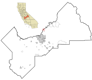
Calwa is an unincorporated census-designated place in Fresno County, California, United States. The population was 2,052 at the 2010 census, up from 762 in 2000. Calwa is located 4 miles (6.4 km) south-southeast of downtown Fresno, at an elevation of 292 feet. The name was taken from the acronym for "California Wine Association" (CalWA).

Caruthers is a census-designated place (CDP) in Fresno County, California, United States. The population was 2,497 at the 2010 census, up from 2,103 at the 2000 census. Caruthers is located 15 miles (24 km) south of downtown Fresno, at an elevation of 246 feet.

Easton is a census-designated place (CDP) in Fresno County, California, United States. The population was 2,083 at the 2010 census, up from 1,966 at the 2000 census. Easton is located 7.5 miles (12.1 km) south of downtown Fresno, at an elevation of 276 feet.
Friant is a census-designated place (CDP) in Fresno County, California, United States. The population was 549 at the 2010 census, down from 778 at the 2000 census. Friant is located 11.5 miles (19 km) north of Clovis, at an elevation of 344 feet.

Lanare is a community and census-designated place (CDP) in Fresno County, California, United States. The population was 589 at the 2010 census, up from 540 at the 2000 census. Lanare is located 24 miles (39 km) south-southwest of Fresno, at an elevation of 207 feet. The name is derived from Llewellyn A. Nares, the community developer. Lanare is currently served by the Riverdale Post Office, zip code 93656, and students attend public school in Riverdale.

Raisin City is a census-designated place (CDP) in Fresno County, California, United States. The population was 380 at the 2010 census, up from 165 at the 2000 census. Raisin City is located 13 miles (21 km) south-southwest of downtown Fresno, at an elevation of 236 feet.

Riverdale is a census-designated place (CDP) in Fresno County, California, United States. The population was 3,153 at the 2010 census, up from 2,416 at the 2000 census. Riverdale is located 23 miles (37 km) south of Fresno, at an elevation of 223 ft (68 m).
Tarpey Village is a census-designated place in Fresno County, California, between Fresno and Clovis, 2 miles (3.2 km) south of the latter, near Tarpey. Tarpey village falls within the Clovis Unified School District. It lies at an elevation of 351 ft (107 m). At the 2010 census, the population was 3,888.
Centerville is a census-designated place in Fresno County, California. It is located on the Atchison, Topeka and Santa Fe Railroad 16 miles (26 km) east of Fresno, at an elevation of 394 feet. At the 2010 census, it had a population of 392.
Minkler is a census-designated place in eastern Fresno County, California. The place is located on Highway 180, 2.25 miles (3.6 km) east-southeast of Centerville and 7.6 miles north of Reedley at an elevation of 397 feet. It has a population of 1,003 people. The town is named for Charles O. Minkler, a local farmer. The current mayor of Minkler is Wyatt Barnett.
Monmouth is a census-designated place in Fresno County, California. It is located 7.25 miles (12 km) west of Selma, at an elevation of 276 feet. At the 2010 census, Monmouth had a population of 152.
Sunnyside is a census-designated place in Fresno County, California. It is located on the Southern Pacific Railroad 5 miles (8 km) north-northeast of Malaga, at an elevation of 328 ft (100 m). It is an eastern suburb of Fresno. At the 2010 census, Sunnyside's population was 4,235.
Three Rocks is a census-designated place in Fresno County, California, United States. It lies at an elevation of 423 ft (129 m). The population is 246. It was founded by Raymond Minnite of Hiawatha, Utah in 1954. While sitting at the corner of Clarkson Ave and Derrick Ave counting cars; dreaming about how many he could make stop; he peered three large boulders off in the horizon where the blue ridge, better known as the Sierra Madre mountain range, met the sky. It was on a cold foggy morning in the fall of 1952 he decided on the name for the town he would will into being. Raymond’s dream had a name… Three Rocks, California.
West Park is a census-designated place in Fresno County, California. It is located 5 miles (8 km) southwest of downtown Fresno, at an elevation of 266 ft (81 m). West Park's population is 1,157.
Malaga is a census-designated place in Fresno County, California. It is located 6 miles (9.7 km) south-southeast of downtown Fresno, at an elevation of 295 feet. As of the 2010 census, Malaga had a population of 947.
Fairmead is a census-designated place in Madera County, California, United States. It is located 11 miles (18 km) northwest of Madera, at an elevation of 253 feet (77 m), and bordered to the northwest by Chowchilla. The population was 1,235 at the 2020 census.
Rolling Hills is an unincorporated community and census-designated place (CDP) in Madera County, California, United States, north of Fresno on State Route 41. It lies at an elevation of 371 feet (113 m). The population was 793 at the 2020 census.

California Hot Springs is a census-designated place in Tulare County, California, United States. California Hot Springs is 20 miles (32 km) east of Ducor. California Hot Springs has a post office with ZIP code 93207. The population was 50 at the 2020 census, up from 37 at the 2010 census.

Fort Washington is a census-designated place in Fresno County, California. Fort Washington sits at an elevation of 249 feet (76 m). The 2010 United States census reported Fort Washington's population was 233.
Mayfair is a census-designated place in Fresno County, California, United States. Mayfair sits at an elevation of 249 feet (76 m). The 2010 U.S. census reported Mayfair's population was 4,589.

