Millwood, California

Last updated

Millwood
Former settlement
Big Trees Stage at the Sequoia Hotel.jpg
The Big Trees Stage at the Sequoia Hotel in Millwood.
USA California location map.svg
Red pog.svg
Millwood
Location in California
Coordinates: 36°43′42″N118°59′51″W / 36.72833°N 118.99750°W / 36.72833; -118.99750 Coordinates: 36°43′42″N118°59′51″W / 36.72833°N 118.99750°W / 36.72833; -118.99750
CountryUnited States
StateCalifornia
County Fresno County
Elevation
[1]
3,584 ft (1,092 m)

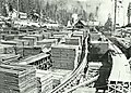
Millwood was a lumber boomtown located in present-day Sequoia National Forest near Converse Basin Grove in California. It was established in 1891 by the Kings River Lumber Company and was connected to the Sequoia Railroad, which brought logs to the town to be turned into rough lumber. The lumber was then transported by log flume to Sanger, a journey of 54 miles. At its peak, Millwood had a population of over 2,000 people and featured two hotels, a summer school, and a post office. However, today there are no remaining structures or buildings at the Millwood site.

Contents

History

In 1888, the Kings River Lumber Company was founded by Hiram T. Smith and Austin D. Moore. As part of their operation, they constructed the Millwood sawmill, a high-elevation mill located near the headwaters of the Kings River. The mill was connected to a 54-mile log flume, which transported lumber from the mill to the town of Sanger. Sequoia Lake, a man-made reservoir, served as the source of water for the flume.

In the late 1800s, Millwood was a thriving lumber city with a workforce of over 2,000 people during the April to November lumber season. The town had a range of amenities including a summer school, post office, store, blacksmith shop, and butcher shop. Loggers lived in rough dormitories and ate at a common cookhouse. There were also two hotels, the Sequoia Hotel and the Red House Hotel, which provided meals and beds for two-bits each. There were also summer shacks available for rent. There was a red-light district a mile south of the main town. [2] :144

In the early 1890s, Fresno County built a new stage road connecting the town of Sanger to Millwood, improving access to the Sierra region. [3] :46 This led to an increase in people visiting the Converse Basin Grove and the newly established General Grant National Park. [4] [5] The stagecoach journey took 12 hours and covered a distance of 47 miles, running three times per week. However, the stagecoach also became a target for robberies, with outlaws Christopher Evans and John Sontag carrying out a holdup on the Millwood coach in 1892. [3] :38

Pioneer photographer C.C. Curtis established a photography studio in Millwood, near the Sequoia Hotel, between 1887 and 1893. During this time, he used large scale glass plate negatives to photograph the loggers and tourists in the area. The surviving images captured by Curtis are some of the only surviving photographs of the giant sequoia logging era.

Decline

In 1905, the Hume-Bennett Lumber Company, the successor to the Kings River Lumber Company, relocated its logging operations to a new site and established the town of Hume. The company built a new logging complex, which included Hume Lake. This became the new center of economic activity in the area. As a result, Millwood quickly declined. The landmark White House Hotel burned in 1908. By 1909, the mill had closed and the remaining machinery moved the ten miles to Hume. [6]

Today, Millwood is a ghost town with no remaining buildings. The town's former site is currently marked by a United States Forest Service off-highway vehicle (OHV) area. A historical marker was installed in 1965 in nearby Squaw Valley, located at the intersection of Highway 180 and National Forest Road 13S97. It's on the right when traveling west on Highway 180, located near the post office. [7]

Related Research Articles

<span class="mw-page-title-main">Sierra Nevada</span> Mountain range in the Western United States

The Sierra Nevada is a mountain range in the Western United States, between the Central Valley of California and the Great Basin. The vast majority of the range lies in the state of California, although the Carson Range spur lies primarily in Nevada. The Sierra Nevada is part of the American Cordillera, an almost continuous chain of mountain ranges that forms the western "backbone" of the Americas.

<span class="mw-page-title-main">Log flume</span> Type of flume used to float logs to a sawmill

A log flume is a watertight flume constructed to transport lumber and logs down mountainous terrain using flowing water. Flumes replaced horse- or oxen-drawn carriages on dangerous mountain trails in the late 19th century. Logging operations preferred flumes whenever a reliable source of water was available. Flumes were cheaper to build and operate than logging railroads. They could span long distances across chasms with more lightweight trestles.

<span class="mw-page-title-main">Kings Canyon National Park</span> National park in California, United States

Kings Canyon National Park is an American national park in the southern Sierra Nevada, in Fresno and Tulare Counties, California. Originally established in 1890 as General Grant National Park, the park was greatly expanded and renamed to Kings Canyon National Park on March 4, 1940. The park's namesake, Kings Canyon, is a rugged glacier-carved valley more than a mile (1,600 m) deep. Other natural features include multiple 14,000-foot (4,300 m) peaks, high mountain meadows, swift-flowing rivers, and some of the world's largest stands of giant sequoia trees. Kings Canyon is north of and contiguous with Sequoia National Park, and both parks are jointly administered by the National Park Service as the Sequoia and Kings Canyon National Parks.

<span class="mw-page-title-main">Sequoia National Park</span> National park in the Sierra Nevada mountains, California, U.S.

Sequoia National Park is an American national park in the southern Sierra Nevada east of Visalia, California. The park was established on September 25, 1890, and today protects 404,064 acres of forested mountainous terrain. Encompassing a vertical relief of nearly 13,000 feet (4,000 m), the park contains the highest point in the contiguous United States, Mount Whitney, at 14,505 feet (4,421 m) above sea level. The park is south of, and contiguous with, Kings Canyon National Park; both parks are administered by the National Park Service together as the Sequoia and Kings Canyon National Parks. UNESCO designated the areas as Sequoia-Kings Canyon Biosphere Reserve in 1976.

<span class="mw-page-title-main">Kings River (California)</span> River in central California, US

The Kings River is a 132.9-mile (213.9 km) river draining the Sierra Nevada mountain range in central California in the United States. Its headwaters originate along the Sierra Crest in and around Kings Canyon National Park and form the eponymous Kings Canyon, one of the deepest river gorges in North America. The river is impounded in Pine Flat Lake before flowing into the San Joaquin Valley southeast of Fresno. With its upper and middle course in Fresno County, the Kings River diverges into multiple branches in Kings County, with some water flowing south to the old Tulare Lake bed and the rest flowing north to the San Joaquin River. However, most of the water is consumed for irrigation well upstream of either point.

<span class="mw-page-title-main">Hume Lake</span> Body of water

Hume Lake is a reservoir in the Sierra Nevada, within Sequoia National Forest and Fresno County, central California.

<span class="mw-page-title-main">Nelder Grove</span> Giant sequoia grove in Madera County, California, United States

Nelder Grove, located in the western Sierra Nevada within the Sierra National Forest in Madera County, California, is a Giant sequoia grove that was formerly known as Fresno Grove. The grove is a 1,540-acre (6.2 km2) tract containing 54 mature Giant Sequoia trees, the largest concentration of giant sequoias in the Sierra National Forest. The grove also contains several historical points of interest, including pioneer cabins and giant sequoia stumps left by 19th century loggers.

<span class="mw-page-title-main">Sequoia National Forest</span> National forest in the U.S. state of California

Sequoia National Forest is located in the southern Sierra Nevada mountains of California. The U.S. National Forest is named for the majestic Giant Sequoia trees which populate 38 distinct groves within the boundaries of the forest.

<span class="mw-page-title-main">Kaweah River</span> River in the United States of America

The Kaweah River is a river draining the southern Sierra Nevada in Tulare County, California in the United States. Fed primarily by high elevation snowmelt along the Great Western Divide, the Kaweah begins as four forks in Sequoia National Park, where the watershed is noted for its alpine scenery and its dense concentrations of giant sequoias, the largest trees on Earth. It then flows in a southwest direction to Lake Kaweah – the only major reservoir on the river – and into the San Joaquin Valley, where it diverges into multiple channels across an alluvial plain around Visalia. With its Middle Fork headwaters starting at almost 13,000 feet (4,000 m) above sea level, the river has a vertical drop of nearly two and a half miles (4.0 km) on its short run to the San Joaquin Valley, making it one of the steepest river drainages in the United States. Although the main stem of the Kaweah is only 33.6 miles (54.1 km) long, its total length including headwaters and lower branches is nearly 100 miles (160 km).

<span class="mw-page-title-main">Jennie Lakes Wilderness</span> Protected wilderness area in California, United States

Jennie Lakes Wilderness is a protected area in the Sierra Nevada, in Tulare County, California. It is located 60 miles (97 km) east of Fresno and managed by the US Forest Service. Jennie Lakes Wilderness is about nine square miles within the Sequoia National Forest, that was established by the California Wilderness Act of 1984, and added to the National Wilderness Preservation System.

<span class="mw-page-title-main">Converse Basin Grove</span> Giant sequoia grove in Fresno County, California, United States

Converse Basin Grove is a grove of giant sequoia trees in the Giant Sequoia National Monument in the Sierra Nevada, in Fresno County, California, 5 miles (8 km) north of General Grant Grove, just outside Kings Canyon National Park. Once home to the second-largest population of giant sequoias in the world, covering 4,600 acres (19 km2) acres, the grove was extensively logged by the Sanger Lumber Company at the turn of the 20th century. The clearcutting of 8,000 giant sequoias, many of which were over 2,000 years old, resulted in the destruction of the old-growth forest ecosystem.

The Monarch Wilderness is a federally designated wilderness area located 70 miles east of Fresno, California, in the Sierra Nevada mountain range. It encompasses 44,896 acres (181.69 km2) within both the Sequoia National Forest and the Sierra National Forest and is managed by the United States Forest Service. Elevations range from 950 feet (290 m) to 11,081 ft (3,377 m).

Hume is an unincorporated community in Fresno County, California. It is located 50 miles (80 km) east of Fresno, at an elevation of 5344 feet. Hume is located in the 93628 ZIP Code, in area code 559.

<span class="mw-page-title-main">Balch Park</span>

Balch Park is a county park in the southern Sierra Nevada mountains of California that features a grove of Giant Sequoia trees. It also has archaeological sites relating to the early Native Americans of the area, and to the late 19th- and early 20th-century logging industry that cut down many of the big trees in the area.

<span class="mw-page-title-main">Rough Fire</span> 2015 wildfire in Fresno County, California

The Rough Fire was a wildfire of the 2015 California season. It burned 151,623 acres (61,360 ha) of land, a season record, and was extinguished by 3,742 firefighters.

<span class="mw-page-title-main">Hume-Bennett Lumber Company</span>

The Hume-Bennett Lumber Company was a logging operation in the Sequoia National Forest in the late 19th and early 20th centuries. The company and its predecessors were known for building the world's longest log flume and the first multiple-arch hydroelectric dam. However, the company also engaged in destructive clearcutting logging practices, cutting down 8,000 giant sequoias in Converse Basin in a decade-long event that has been described as "the greatest orgy of destructive lumbering in the history of the world."

<span class="mw-page-title-main">Mountain Home Demonstration State Forest</span>

Mountain Home Demonstration State Forest (MHDSF) is a state forest located on Bear Creek Road (Tulare County Route 220), 28 km (17 mi) northeast of Springville in Tulare County, California. The protected land covers an area of 4,807 acres (19 km2) with an elevation range between 1,463 m (4,800 ft) and 2,377.5 m (7,800 ft). The forest is best known for its namesake giant sequoia grove, Mountain Home Grove, which is home to some of the largest giant sequoias in the world.

<span class="mw-page-title-main">Madera Sugar Pine Company</span> Defunct logging company in Madera County, California, US

The Madera Sugar Pine Company was a lumber company that operated in the Sierra Nevada region of California during the late 19th and early 20th centuries. It was known for its use of innovative technologies, such as the first log flume and logging railroad in the southern Sierra, and the adoption of the Steam Donkey engine in commercial logging. The company had a significant impact on the region, leading to the founding of several towns, including Madera, Fish Camp, and Sugar Pine, as well as the growth of Fresno Flats and the formation of Madera County. In addition, the company contributed to the agriculture in California in California through its production of wooden shipping boxes and was involved in a U.S. Supreme Court case related to employer obligations.

<span class="mw-page-title-main">C.C. Curtis</span> American pioneer photographer

Charles Clifford Curtis was a pioneering American photographer who is best remembered for his documentary photography of the logging industry in the Sierra Nevada mountains in the late 19th century. His photographs, which captured the felling of the famous Mark Twain Tree and the General Noble tree, helped to convince the public that these giant sequoias were not a hoax. Curtis was well-known for his use of large plate photography, which allowed him to capture portraits of people and gatherings that were dwarfed by the scale of the giant trees. His images of logging crews working in the rugged terrain of Converse Basin are considered some of the most iconic and enduring images of the era.

References

  1. U.S. Geological Survey Geographic Names Information System: Millwood, California
  2. 1 2 McDougall Weiner, Jackie (2009). Timely Exposures: The Life and Images of C.C. Curtis, Pioneer California Photographer. Tulare, California: Tulare County Historical Society.
  3. 1 2 Johnston, Hank (2003). They Felled the Redwoods (13th ed.). Stauffer Publishing. ISBN   0-87046-003-X.
  4. "Forest Destruction in the High Sierras". Los Angeles Herald. Los Angeles, California. June 2, 1901. Retrieved December 18, 2022.
  5. "Attractions of Grant National Park: The New Pleasure Ground and Kings River Canyon". San Jose. San Jose, California. August 6, 1899. Retrieved December 18, 2022.
  6. "Find Millwood Now Abandoned: Hanford Young Men Return From Auto Tour Into Nearby Sierras". Hanford Journal. Hanford, California. Retrieved January 10, 2023.
  7. Millwood Marker (Plaque near post office). Squaw Valley: E Clampus Vitus. 1965.