Related Research Articles

San Francisco Bay is a shallow estuary in the US state of California. It is surrounded by a contiguous region known as the San Francisco Bay Area, and is dominated by the large cities of San Francisco, San Jose, and Oakland.
San Joaquin County, officially the County of San Joaquin is a county in the U.S. state of California. As of the 2010 census, the population was 685,306. The county seat is Stockton.

The Central Valley is a flat valley that dominates the interior of California. It is 40 to 60 miles wide and stretches approximately 450 miles (720 km) from north-northwest to south-southeast, inland from and parallel to the Pacific Ocean coast. It covers approximately 18,000 square miles (47,000 km2), about 11% of California's total land area. The valley is bounded by the Coast Ranges to the west and the Sierra Nevada to the east.
Lathrop is a city located 9 miles (14 km) south of Stockton in San Joaquin County, California, United States. The 2010 United States Census reported Lathrop's population was 18,023. The city is located in the San Joaquin Valley in Northern California at the intersection of Interstate 5 and SR 120.

The San Joaquin River is the longest river of Central California in the United States. The 366-mile (589 km) long river starts in the high Sierra Nevada, and flows through the rich agricultural region of the northern San Joaquin Valley before reaching Suisun Bay, San Francisco Bay, and the Pacific Ocean. An important source of irrigation water as well as a wildlife corridor, the San Joaquin is among the most heavily dammed and diverted of California's rivers.

San Pablo Bay is a tidal estuary that forms the northern extension of San Francisco Bay in the East Bay and North Bay regions of the San Francisco Bay Area in northern California.

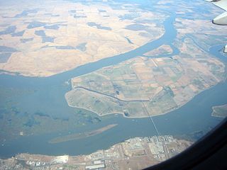
Suisun Bay is a shallow tidal estuary in northern California. It lies at the confluence of the Sacramento River and San Joaquin River, forming the entrance to the Sacramento–San Joaquin River Delta, an inverted river delta. Suisun Marsh, the tidal marsh land to the north, is the largest marsh in California. Grizzly Bay forms a northern extension of Suisun Bay. Suisun Bay is directly north of Contra Costa County.
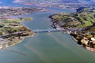
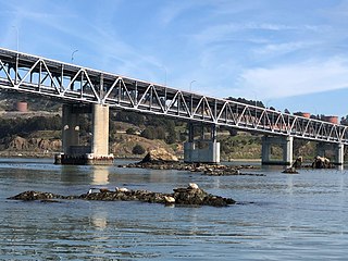
The Carquinez Strait is a narrow tidal strait in Northern California. It is part of the tidal estuary of the Sacramento and the San Joaquin rivers as they drain into the San Francisco Bay. The strait is eight miles (13 km) long and connects Suisun Bay, which receives the waters of the combined rivers, with San Pablo Bay, a northern extension of the San Francisco Bay.
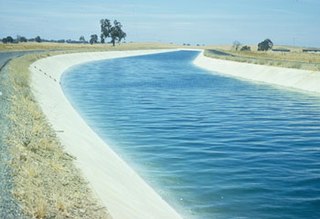
The Delta–Mendota Canal is a 117-mile-long (188 km) aqueduct in central California, United States. The canal was designed and completed in 1951 by the U.S. Bureau of Reclamation as part of the Central Valley Project to supply freshwater to users downstream of the San Joaquin River. Freshwater is diverted into the Madera Canal and Friant-Kern Canal at Friant Dam.
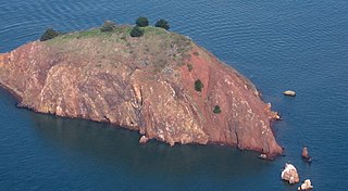
Red Rock Island is an uninhabited, 5.8-acre (2.3 ha) island in the San Francisco Bay located just south of the Richmond–San Rafael Bridge. The property is the only privately owned island in San Francisco Bay. The boundaries of three counties – San Francisco, Marin, and Contra Costa – converge on the island. The San Francisco County portion is an incorporated part of the city of San Francisco since it is a consolidated city-county; the Contra Costa portion is incorporated inside the city limits of Richmond.

Woodbridge is a census-designated place in San Joaquin County, California. Woodbridge sits at an elevation of 43 feet (13 m). The 2010 United States census reported Woodbridge's population was 3,984. Founded in the 1850s, the town is listed as a California Historical Landmark.
The Castro Rocks are several rocks in Richmond, California protruding from the waters in San Francisco Bay between Castro Point and Red Rock Island.The rocks lie almost directly under the Richmond-San Rafael Bridge (I-580).

Ryer Island is an island in the Sacramento-San Joaquin River Delta in Solano County, California surrounded by Miner Slough and Steamboat Slough at their confluence with the Sacramento River, 6.5 miles north-northeast of Rio Vista. The 4,750 ha (11,700-acre) island is named in honor of a California pioneer, Dr. Washington M. Ryer, and his family. A map prepared at the time of statehood shows the area divided by the west fork of the Sacramento River, with the western half identified as Priest Island and the eastern half identified as Sutter Island.
Sherman Island is an island in the Sacramento-San Joaquin River Delta at the confluence of the two rivers in Sacramento County, California, 1.2 miles (1.9 km) northeast of Antioch. The 5,500 ha island, mostly managed by Reclamation District 341, is the meeting point of Sacramento, Solano, and Contra Costa Counties, and is bordered on the north and northwest by the Sacramento River, on the northeast by Three Mile Slough, and on the east, and south west by the San Joaquin River. Sherman Island is a widely known kite and windsurfing area.

Bouldin Island is an island in the Sacramento-San Joaquin River Delta, 20 kilometers (12 mi) northwest of Stockton on the Stockton Deepwater Shipping Channel. It is in San Joaquin County, and managed by Reclamation District 756.
There are 45 routes assigned to the "J" zone of the California Route Marker Program, which designates county routes in California. The "J" zone includes county highways in Alameda, Calaveras, Contra Costa, Fresno, Kern, Inyo, Mariposa, Merced, Sacramento, San Benito, San Joaquin, Stanislaus, and Tulare counties.
Watson's Ferry was a former settlement, river ferry and steamboat landing on Fresno Slough near its confluence with the San Joaquin River nearby to the northeast of modern Mendota in what is now Fresno County, California. Watson's Ferry was located 8 miles southeast of Firebaugh.
Whites Bridge or Whitesbridge is a former settlement on the Fresno Slough near Tranquillity in Fresno County, California.

The San Joaquin River Viaduct is a bridge currently under construction to carry California High-Speed Rail over the San Joaquin River. Most of the bridge is in the city of Fresno, California in Fresno County, although the portion north of the river will be in Madera County. It is the second major river crossing to be constructed as part of California High-Speed Rail, after the Fresno River Viaduct to the north.

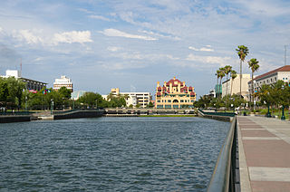
Stockton Deepwater Shipping Channel also called the Baldwin-Stockton Deepwater Shipping Channel or Stockton Deep Water Channel is a manmade deepwater water channel that runs from Suisun Bay and the Sacramento River - Sacramento Deep Water Ship Channel to the Port of Stockton and the Stockton Channel in California. The Stockton Ship Channel is 41 mi (66 km) long and about 37 ft (11 m) deep, allowing up to Panama Canal size ocean ships access to the Port of Stockton at the City of Stockton. The Stockton Deepwater Shipping Channel is part of the vast Sacramento–San Joaquin River Delta that has a connection to the Pacific Ocean. Stockton Deepwater Shipping Channel is also called the lower San Joaquin River.
References

| | This Fresno County, California-related article is a stub. You can help Wikipedia by expanding it. |