Caldwell, North Carolina | |
|---|---|
 Location of Caldwell in North Carolina  Caldwell, Orange County, North Carolina (the United States) | |
| Coordinates: 36°11′24″N79°01′02″W / 36.19000°N 79.01722°W Coordinates: 36°11′24″N79°01′02″W / 36.19000°N 79.01722°W | |
| Country | United States |
| State | North Carolina |
| County | Orange |
| Elevation | 620 ft (190 m) |
| Time zone | UTC-5 (Eastern (EST)) |
| • Summer (DST) | UTC-4 (EDT) |
| Area code(s) | 919 |
| GNIS feature ID | 1006153 [1] |
Caldwell is an unincorporated community in Orange County, North Carolina, United States. It is located at the junction of North Carolina Highway 57 and North Carolina Highway 157, northeast of Schley. [2] Only a rural crossroads, it is the most significant community on fifteen mile stretches of both highways.

Orange County is a county located in the U.S. state of North Carolina. As of the 2010 census, the population was 133,801. Its county seat is Hillsborough.

North Carolina is a state in the southeastern region of the United States. It borders South Carolina and Georgia to the south, Tennessee to the west, Virginia to the north, and the Atlantic Ocean to the east. North Carolina is the 28th-most extensive and the 9th-most populous of the U.S. states. The state is divided into 100 counties. The capital is Raleigh, which along with Durham and Chapel Hill is home to the largest research park in the United States. The most populous municipality is Charlotte, which is the second-largest banking center in the United States after New York City.

North Carolina Highway 57 (NC 57) is a 43.1-mile-long (69.4 km) primary state highway in the U.S. state of North Carolina and a semi-rural traffic artery connecting Roxboro to a few small-to-medium-sized towns in The Triangle region north of the cities of Durham and Chapel Hill.
Caldwell is famous for the annual Fourth of July Parade that starts at the Caldwell Fire Department and ends at the Caldwell Community Center.
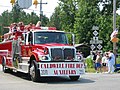 Caldwell 4th of July Parade, 2007
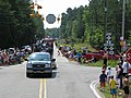 Caldwell 4th of July Parade, 2008
 Caldwell 4th of July Parade, 2010


The Dr. Arch Jordan House was listed on the National Register of Historic Places in 1998. [3]

Dr. Arch Jordan House, also known as the manse for Little River Presbyterian Church, is a historic home located near Caldwell, Orange County, North Carolina. It was built about 1875, and is a two-story, single pile, central hall plan, Italianate style frame dwelling. It features a central projecting gable, bracketed eaves, and a columned porch with a low hipped roof. Attached at the rear is an originally-separate two-story kitchen building. Also on the property are the contributing combination smokehouse/food storage shed, log and weatherboard tobacco barn, and 1 1/2-story main barn.

The National Register of Historic Places (NRHP) is the United States federal government's official list of districts, sites, buildings, structures, and objects deemed worthy of preservation for their historical significance. A property listed in the National Register, or located within a National Register Historic District, may qualify for tax incentives derived from the total value of expenses incurred preserving the property.