
Bridgwater is a historic market town and civil parish in Somerset, England. The town had a population of 41,276 at the 2021 Census. Bridgwater is at the edge of the Somerset Levels, in level and well-wooded country. The town lies along both sides of the River Parrett; it has been a major inland port and trading centre since the industrial revolution. Most of its industrial bases still stand today. Its larger neighbour, Taunton, is linked to Bridgwater via a canal, the M5 motorway and the GWR railway line.

The Quantock Hills west of Bridgwater in Somerset, England, consist of heathland, oak woodlands, ancient parklands and agricultural land. They were England's first Area of Outstanding Natural Beauty, designated in 1956.
The River Tone is a river in the English county of Somerset. The river is about 33 kilometres (21 mi) long. Its source is at Beverton Pond near Huish Champflower in the Brendon Hills, and is dammed at Clatworthy Reservoir. The reservoir outfall continues through Taunton and Curry and Hay Moors, which are designated as a Site of Special Scientific Interest. Finally, it flows into the River Parrett at Burrowbridge.

Somerset is a rural county in the southwest of England, covering 4,171 square kilometres (1,610 sq mi). It is bounded on the north-west by the Bristol Channel, on the north by Bristol and Gloucestershire, on the north-east by Wiltshire, on the south-east by Dorset, and on the south west and west by Devon. It has broad central plains with several ranges of low hills. The landscape divides into four main geological sections from the Silurian through the Devonian and Carboniferous to the Permian which influence the landscape, together with water-related features.

Bridgwater and West Somerset is a constituency represented in the House of Commons of the UK Parliament since 2010 by Ian Liddell-Grainger, a Conservative.

Stogursey is a small village and civil parish in the Quantock Hills in Somerset, England. It is situated 3 miles (4.8 km) from Nether Stowey, and 8 miles (12.9 km) west of Bridgwater. The village is situated near the Bristol Channel, which bounds the parish on the north.

Stockland Bristol is a village and civil parish in Somerset, England, between Bridgwater and the Steart Peninsula.
Otterhampton is a village and civil parish in Somerset, England, between Bridgwater and the Steart Peninsula. The civil parish includes the larger village of Combwich and the small village of Steart.
Spaxton is a small village and civil parish on the Quantocks in Somerset, South West England.

Over Stowey is a small village and civil parish in Somerset, South West England. A large part of the forest and open heath of the Quantock Hills is within the parish and it includes the hamlets of Plainsfield, Aley, Adscombe, Friarn and Bincombe. It is adjacent to Nether Stowey, 8 miles (13 km) north-west of Bridgwater.

Cannington is a village and civil parish 3 miles (5 km) northwest of Bridgwater in Somerset, England. It lies on the west bank of the River Parret, and contains the hamlet of Edstock.

Durleigh is a village and civil parish on the outskirts of Bridgwater in Somerset, England. According to the 2011 Census, it had a population of 548. Its nearest town is Bridgwater, which lies approximately 1.6 miles (2.6 km) north-east from the village.

Ashford Reservoir is a small reservoir on the eastern side of the Quantock Hills near the villages of Charlynch and Spaxton in Somerset, England. It was constructed 1934 as a water supply reservoir for Bridgwater.

Bridgwater and Taunton College is a further education college based in the heart of Somerset, England, with main centres in Bridgwater, Taunton and Cannington. It educates approximately 3000 students between the ages of 16–18 in academic and vocational programmes in addition to several thousand part-time or mature students. The college was founded in 1973, although the history of its predecessor institutions dates to 1891.
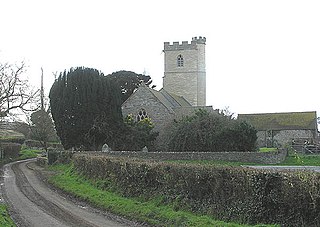
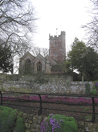
The Church of St Mary is the parish church of Cannington, Somerset, England. The parish is in the Church of England Diocese of Bath and Wells.

The county of Somerset is in South West England, bordered by the Bristol Channel and the counties of Bristol and Gloucestershire to the north, and Wiltshire to the east, Dorset to the south, and Devon to the west. The climate, influenced by its proximity to the Atlantic Ocean and the prevailing westerly winds, tends to be mild, damp and windy.

Hawkridge Reservoir is a reservoir near Spaxton, Somerset, England.

The Buses of Somerset is the trading name used by bus operator First South West for services operated in Somerset from its depot in the town of Taunton since 2014. The services were formerly managed as part of First Somerset & Avon.

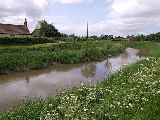
Peart Water is a stream about 5 miles (8.0 km) long in Somerset, England. It rises in the Quantock Hills and flows in a generally northeast direction. Fish are raised in the Hawkridge Reservoir, and further downstream the Peart Water powers two mills.
