Perry County is a county located in the U.S. state of Tennessee. As of the 2010 census, the population was 7,915. Its county seat is Linden. The county was named after the War of 1812 naval hero Oliver Hazard Perry.

Grove Hill is a town in Clarke County, Alabama, United States. At the 2010 census the population was 1,570. It is the county seat of Clarke County and home of the Clarke County Museum.

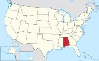
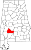
This is a list of the National Register of Historic Places listings in Wilcox County, Alabama.

Prairieville is an unincorporated community in Hale County, Alabama, United States.

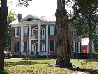
The William King Beck House, also known as River Bluff Plantation, is a historic plantation house on the Alabama River near Camden, Alabama. The main house was built in 1845 for William King Beck and is attributed to architect Alexander J. Bragg. William King Beck was an attorney from North Carolina who migrated to Wilcox County in the 1820s. He was the nephew of William Rufus King, the 13th Vice President of the United States.

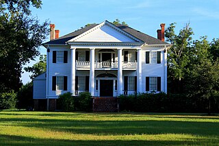
Liberty Hall, also known as John Robert McDowell Place, is a historic plantation house near Camden, Alabama. The two-story Greek Revival style main house was built in 1855 for John Robert McDowell by W.W. Robinson. The two-story front portico features two central Ionic columns flanked by a square column to each side, reminiscent of a distyle-in-antis arrangement. The floor plan is centered on a broad hall that separates four large, equally proportioned rooms on both levels. The formal rooms and hall on the lower level have elaborate plasterwork that was designed, in part, by Harriet McDowell, wife of John Robert McDowell. The house is currently owned by the great-granddaughter of the original owner. It was added to the National Register of Historic Places on January 5, 1984.
The Tristram Bethea House, also known as Pleasant Ridge, is a historic plantation house in Canton Bend, Alabama. The two-story brick house was built in 1842 in the Federal style. It was added to the National Register of Historic Places on July 11, 1985.
Coy is an unincorporated community in Wilcox County, Alabama, United States. Coy is located in a bend of the Alabama River and is home to several historic plantations. The most notable of these is Dry Fork Plantation, included on the National Register of Historic Places.

Dry Fork Plantation, also known as James Asbury Tait House, is a historic plantation house in Coy, Alabama. The two-story wood-frame house was built between 1832 and 1834 in a vernacular interpretation of Federal style architecture. It was built for James Asbury Tait by two slaves, Hezekiah and Elijah. The floor plan is centered on a hall that separates four rooms, two on each side, on both floors. Tait recorded in his daybook that the house required 25,000 board feet (59 m3) of lumber, the roof was covered with 6,000 wooden shingles, and the chimneys and foundation required 12,000 bricks, made from clay on the plantation. Dry Fork is one of the oldest houses still standing in Wilcox County and remains in the Tait family. It was added to the National Register of Historic Places on February 26, 1999 with the name of Dry Forks Plantation.
Furman, also known as Old Snow Hill, is an unincorporated community in Wilcox County, Alabama, United States. The Furman Historic District is included on the National Register of Historic Places.

The Snow Hill Normal and Industrial Institute, also known as the Colored Industrial and Literary Institute of Snow Hill, was a historic African American school in Snow Hill, Alabama. It was founded in 1893 by Dr. William J. Edwards, a graduate of Tuskegee University, and began in a one-room log cabin. The school grew over time to include a campus of 27 buildings, a staff of 35, and over 400 students. The school was operated as a private school for African-American children until Dr. Edward's retirement in 1924, when it became a public school operated by the State of Alabama. The school closed in 1973, after the desegregation of the Wilcox County school system. Out of the original 27 buildings, only eight survive today. They range in architectural style from Queen Anne to Craftsman and include the founder's home, five teachers' cottages, and the library. The National Snow Hill Alumni Association and the local Snow Hill Institute supporters determined to save the remaining structures in 1980. In June 1980, Dr. Edwards' granddaughter and Snow Hill alumna Consuela Lee Moorehead reopened the school as the Springtree/Snow Hill Institute for the Performing Arts and ran after-school and summer programs for local students. The art institute continued to run until 2003 when Moorehead's declining health caused her to close down the school. The school was listed on the National Register of Historic Places on February 24, 1995.
Snow Hill is an unincorporated community in Wilcox County, Alabama, United States. Snow Hill has one site included on the National Register of Historic Places, the Snow Hill Normal and Industrial Institute.

Ackerville is an unincorporated community in Wilcox County, Alabama, United States. Ackerville has one site included on the National Register of Historic Places, the Ackerville Baptist Church of Christ.

Prairie Bluff, also known as Dale and Daletown, is a ghost town in Wilcox County, Alabama.
Millers Ferry is an unincorporated community in Wilcox County, Alabama, United States. The Millers Ferry Lock and Dam is located near the community on the Alabama River.

The William "Bill" Dannelly Reservoir is a reservoir created by Millers Ferry Lock and Dam on the Alabama River in Dallas County and Wilcox County in Alabama. It covers 27 square miles (70 km2) and has approximately 500 miles (800 km) of shoreline. It was named for William "Bill" Dannelly, a former Wilcox County probate judge credited with leading the modernization of the Alabama and Coosa Rivers.

Prairie is an unincorporated community in Wilcox County, Alabama. Prairie has one site listed on the National Register of Historic Places, the Prairie Mission school.
Youpon Plantation, originally known as Mimosa and also known as the Mathews-Tait-Rutherford House, is a historic antebellum plantation house and complex near Canton Bend, Alabama, United States. The three story Greek Revival-style plantation house was completed in 1848. It was extensively recorded by the Historic American Buildings Survey in 1936 and 1937. It was named for the Yaupon holly trees that were once a prominent feature of the front grounds. Architectural historians at the Alabama Historical Commission consider it to be among the most notable of the "stately pillared houses" in Alabama.
Rockwest, also known as Possum Bend, is an unincorporated community in Wilcox County, Alabama.