Prairie Bluff, Alabama

Last updated

Prairie Bluff, Alabama
Prairie Bluff.jpg
Prairie Bluff, taken from the Alabama River in 1894. Some buildings and the cotton slide were still present at this time.
USA Alabama location map.svg
Red pog.svg
Prairie Bluff, Alabama
Location within the state of Alabama
Usa edcp location map.svg
Red pog.svg
Prairie Bluff, Alabama
Prairie Bluff, Alabama (the United States)
Coordinates: 32°8′3.52″N87°24′12.99″W / 32.1343111°N 87.4036083°W / 32.1343111; -87.4036083
Country United States
State Alabama
County Wilcox
Elevation
141 ft (43 m)
Time zone UTC-6 (Central (CST))
  Summer (DST) UTC-5 (CDT)
Area code 334

Prairie Bluff, also known as Dale and Daletown, is a ghost town in Wilcox County, Alabama. [1]

Contents

History

Prairie Bluff first appeared on maps in 1819, the same year that Alabama was admitted to the Union as a state. It was listed erroneously as Prairie Blue on Fielding Lucas' Geographic, Statistical, and Historical Map of Alabama, printed in Philadelphia in 1822. However, another of Lucas' Alabama maps, also printed in 1822, lists it as Prairie Bluff. It is interchangeably listed as Dale, Daletown, or Prairie Bluff on subsequent maps from the 1830s until the mid-1850s, after which time Prairie Bluff is the only name used. It disappeared from maps altogether around 1900. [2] The historic Greek-Revival style Dale Masonic Lodge No. 25 in Camden, completed in 1848, was originally established in what was known as Dale during 1827. [3] The members voted to move their lodge during the 1840s to the county seat in Camden, incorporated in 1842. The county seat had been a short distance from Prairie Bluff, in the community of Canton Bend, until moved to Barboursville (later renamed Camden) in 1833. [4]

The town was located at the midpoint of an early road that connected Cahaba, the first state capital, and St. Stephens, the territorial capital. Situated atop a cliff overlooking the Alabama River, the town grew as river trade increased. A large cotton slide, used to move bales of cotton from the top of the cliff to paddle steamers on the river below, was located at the site. The steamboat Pittsburg sank near Prairie Bluff in May 1828, followed by the Jewess on October 28, 1841. [2]

The town was at its height in 1861, but declined rapidly in importance with the introduction of new railroads following the American Civil War. [2] Portions of the site were inundated by the William "Bill" Dannelly Reservoir with the construction of the nearby Millers Ferry Lock and Dam in 1963. The only physical feature that remains at the site today is the Prairie Bluff Cemetery, with marked graves dating from the 1830s to the 1860s. [5]

Geography

The site of Prairie Bluff is located at 32°08′04″N87°24′13″W / 32.1343111°N 87.4036071°W / 32.1343111; -87.4036071 , it has an elevation of 141 feet (43 m). [1] The site is located on an exposed portion of the Prairie Bluff Chalk Formation, a geological formation that was named after the town. [6]

Notable native

See also

Related Research Articles

<span class="mw-page-title-main">Dallas County, Alabama</span> County in Alabama, United States

Dallas County is a county located in the central part of the U.S. state of Alabama. As of the 2020 census, its population was 38,462. The county seat is Selma. Its name is in honor of United States Secretary of the Treasury Alexander J. Dallas, who served from 1814 to 1816.

<span class="mw-page-title-main">Wilcox County, Alabama</span> County in Alabama, United States

Wilcox County is a county of the U.S. state of Alabama. As of the 2020 census, the population was 10,600. Its county seat is Camden.

<span class="mw-page-title-main">Camden, Alabama</span> City in and county seat of Wilcox County, Alabama

Camden is a city in and the county seat of Wilcox County, Alabama, United States. The population was 2,020 at the 2010 census, down from 2,257 in 2000, at which time it was a town.

<span class="mw-page-title-main">Camden, Arkansas</span> City in Arkansas, United States

Camden is a city in and the county seat of Ouachita County in the south-central part of the U.S. state of Arkansas. The city is located about 100 miles south of Little Rock. Situated on bluffs overlooking the Ouachita River, the city developed because of the river.

<span class="mw-page-title-main">Washington-on-the-Brazos, Texas</span> Unincorporated community in Texas, United States

Washington-on-the-Brazos is an unincorporated community along the Brazos River in Washington County, Texas, United States. The town is best known for being the site of the Convention of 1836 and the signing of the Texas Declaration of Independence.

Grove Oak is a small unincorporated community in DeKalb County, Alabama, United States. It is located atop Sand Mountain in northeastern Alabama.

<span class="mw-page-title-main">Black Belt (region of Alabama)</span> Region of Alabama originally named for black topsoil

The Black Belt is a region of the U.S. state of Alabama. The term originally referred to the region's rich, black soil, much of it in the soil order Vertisols. The term took on an additional meaning in the 19th century, when the region was developed for cotton plantation agriculture, in which the workers were enslaved African Americans. After the American Civil War, many freedmen stayed in the area as sharecroppers and tenant farmers, continuing to comprise a majority of the population in many of these counties.

Old Spring Hill is an unincorporated community in Marengo County, Alabama, United States.

Half Acre is an unincorporated community in Marengo County, Alabama, United States. It has gone through a variety of name changes since the early 20th century. The community had a post office at one time, but it no longer exists. Although a thriving community in its early years, it has since dwindled into obscurity.

<span class="mw-page-title-main">McKinley, Alabama</span> Unincorporated community in Alabama, United States

McKinley is an unincorporated community in Marengo County, Alabama, United States. McKinley had a post office at one time, but it no longer exists. Although a thriving community in its earliest years, it has since dwindled into obscurity.

<span class="mw-page-title-main">William "Bill" Dannelly Reservoir</span> Reservoir in Dallas / Wilcox counties, Alabama

The William "Bill" Dannelly Reservoir is a reservoir created by Millers Ferry Lock and Dam on the Alabama River in Dallas County and Wilcox County in Alabama. It covers 27 square miles (70 km2) and has approximately 500 miles (800 km) of shoreline. It was named for William "Bill" Dannelly, a former Wilcox County probate judge credited with leading the modernization of the Alabama and Coosa Rivers.

Amphion is an unincorporated community in Atascosa County, in the U.S. state of Texas. According to the Handbook of Texas, the community had a population of 26 in 2000. It is located within the San Antonio metropolitan area.

<span class="mw-page-title-main">Claiborne, Alabama</span> Ghost town in Alabama, United States

Claiborne is a ghost town on a bluff above the Alabama River in Monroe County, Alabama.

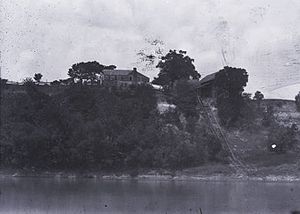
Canton Bend, once known simply as Canton, is an unincorporated community in Wilcox County, Alabama, United States. Located on the south bank of the Alabama River, it served as the first county seat for Wilcox County from 1819 until its move to Camden in 1833. It has several historic sites, including Youpon Plantation and the Tristram Bethea House.

Moores Bluff is a ghost town in Lowndes County, Mississippi, United States.

Ruthven is a ghost town in Wilcox County, Alabama. Ruthven is named in honor of Ruthven, a division of Lincolnshire. It was formerly a lumber town in the early 20th century, and was incorporated in 1924. It was located about 3 1/2 miles southwest of Pine Apple on Bear Creek along the Selma to Flomaton branch of the Louisville & Nashville Railroad, what is now County Road 2. In 1930, it had 523 residents, making it the second largest town in Wilcox County after the county seat of Camden. Shortly afterwards, the town either disincorporated or lost its charter and rapidly declined. Very little exists of the town today as most of its buildings were dismantled. A post office was also located at Ruthven for a time.

<span class="mw-page-title-main">Binnsville, Mississippi</span> Ghost town in Mississippi, United States

Binnsville is a ghost town in Kemper County, Mississippi, United States.

<span class="mw-page-title-main">Dale Masonic Lodge</span> Historic site in Camden, Alabama

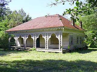
The Dale Masonic Lodge, at the intersection of Broad St. and Clifton St. in Camden, Alabama, was built around 1848.

House Rock is a ghost town near the northwest end of the House Rock Valley in northern Coconino County, Arizona, United States. The community was named after the House Rock Valley, which was named by the John Wesley Powell Expedition in 1871.

References

  1. 1 2 U.S. Geological Survey Geographic Names Information System: Prairie Bluff, Alabama
  2. 1 2 3 Harris, W. Stuart (1977). Dead towns of Alabama. Tuscaloosa, Alabama: University of Alabama Press. pp. 98–99. ISBN   0-585-26563-1.
  3. "Dale Masonic Lodge at Camden, AL (1848)". Rural Southwest Alabama. Retrieved May 6, 2014.
  4. "Wilcox County". The Encyclopedia of Alabama. Retrieved May 6, 2014.
  5. U.S. Geological Survey Geographic Names Information System: Prairie Bluff Cemetery
  6. Ryder, Graham (1996). The Cretaceous-Tertiary Event and Other Catastrophes in Earth History. Boulder, Colorado: Geological Society of America. pp. 271–273. ISBN   0-8137-2307-8.