Montgomery County is located in the State of Alabama. As of the 2020 census, its population was 228,954, making it the fifth-most populous county in Alabama. Its county seat is Montgomery, the state capital. Montgomery County is included in the Montgomery, AL Metropolitan Statistical Area.
Bullock County is a county of the U.S. state of Alabama. As of the 2020 census, the population was 10,357. Union Springs was chosen as the county seat in 1867, and presently is the county's only incorporated city. The county was named for Confederate Army Colonel Edward C. Bullock who was a state senator and outspoken secessionist who died during the American Civil War.

Butler County is a county located in the south central portion of the U.S. state of Alabama. As of the 2020 census, the population was 19,051. Its county seat is Greenville. Its name is in honor of Captain William Butler, who was born in Virginia and fought in the Creek War, and who was killed in May 1818.

Clarke County is a county located in the southwestern part of the U.S. state of Alabama. As of the 2020 census, the population was 23,087. The county seat is Grove Hill. The county's largest city is Jackson. The county was created by the legislature of the Mississippi Territory in 1812. It is named in honor of General John Clarke of Georgia, who was later elected governor of that state.

Dallas County is a county located in the central part of the U.S. state of Alabama. As of the 2020 census, its population was 38,462. The county seat is Selma. Its name is in honor of United States Secretary of the Treasury Alexander J. Dallas, who served from 1814 to 1816.
Greene County is a county located in the west central portion of the U.S. state of Alabama. As of the 2020 census, the population was 7,730, the least populous county in Alabama. Its county seat is Eutaw. It was named in honor of Revolutionary War General Nathanael Greene of Rhode Island.

Mobile County is located in the southwestern corner of the U.S. state of Alabama. It is the second most-populous county in the state after Jefferson County. As of the 2020 census, its population was 414,809. Its county seat is Mobile, which was founded as a deepwater port on the Mobile River. The only such port in Alabama, it has long been integral to the economy for providing access to inland waterways as well as the Gulf of Mexico.
Monroe County is a county located in the southwestern part of the U.S. state of Alabama. As of the 2020 census, the population was 19,772. Its county seat is Monroeville. Its name is in honor of James Monroe, fifth President of the United States. It is a dry county, in which the sale of alcoholic beverages is restricted or prohibited, but Frisco City and Monroeville are wet cities.

Washington County is a county located in the southwestern part of the U.S. state of Alabama. As of the 2020 census, the population was 15,388. The county seat is Chatom. The county was named in honor of George Washington, the first President of the United States. It is a dry county, with the exception of Chatom. In September 2018 The United States Office of Management and Budget (OMB) added Washington County to the Mobile, Alabama Metropolitan Statistical Area. It is also part of the larger Mobile-Daphne-Fairhope, AL Combined Statistical Area.

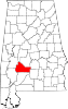
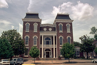
Wilcox County is a county of the U.S. state of Alabama. As of the 2020 census, the population was 10,600. Its county seat is Camden.

Jasper County is located in the U.S. state of Mississippi. At the 2010 census, the population was 17,062. In 1906, the state legislature established two county courts, one at the first county seat of Paulding in the eastern part of the county and also one at Bay Springs in the west, where the railroad had been constructed. Jasper County is part of the Laurel, MS Micropolitan Statistical Area.

Atmore is a city in Escambia County, Alabama, United States. It was incorporated in 1907. As of the 2020 census, it has a population of 8,391. Atmore is in the planning stages to increase its economic base with additions in its new Rivercane development along the I-65 corridor.
Camden is a city in and the county seat of Wilcox County, Alabama, United States. The population was 2,020 at the 2010 census, down from 2,257 in 2000, at which time it was a town.

Oak Hill is a town in Wilcox County, Alabama, United States. According to the 1940 U.S. Census, it incorporated in 1938. Per the 2020 census, the population was 14. It is the smallest incorporated town in Alabama as of 2020, succeeding McMullen. The smallest unincorporated census-designated place in the state is also located in Wilcox County, that of Catherine, which had 22 residents as of 2010. With a median household income of $9,286, Oak Hill is the poorest community in Alabama.

Belmont is a town in Tishomingo County, Mississippi, United States. The population was 2,021 at the 2010 census.

Eastaboga is an unincorporated community on the border of Talladega and Calhoun counties in the U.S. state of Alabama. It was previously called McFall, named for a settling family in the 1850s, and incorporated in 1898, only to be disincorporated in 1901. The original community of Eastaboga was to the south and became known as Old Eastaboga after McFall's name was changed to Eastaboga.

Semmes is a city in western Mobile County, Alabama, in the Mobile metropolitan area. It was incorporated in 2011. As of the 2020 census, the population was 4,941.

Walls is a town located in northern DeSoto County, Mississippi, United States, near the Mississippi River, part of the larger region known as "The Delta", and known for its rich, dark soil. As it is in the upper northwest corner of Mississippi, it is in the Memphis, Tennessee metropolitan area. Its ZIP code is 38680. As of the 2010 census it had a population of 1,162, with an estimated population of 1,463 in 2018.
Wilmer is an unincorporated community in Mobile County, Alabama, United States.
Nadawah is a ghost town in Monroe County, Alabama.