Capitol Hill, Denver

Last updated
Capitol Hill
Neighborhood
Denver capital.jpg
Colorado State Capitol Building, at the western edge of the Capitol Hill neighborhood
CountryUnited States of America
StateColorado
CityDenver
Area
  Total0.6 sq mi (2 km2)
Population
 (2020) [1]
  Total16,675
  Density27,792/sq mi (10,731/km2)

Located in the city and county of Denver, Colorado, the Capitol Hill neighborhood is bordered by Broadway, Downing Street, Colfax Avenue, and Seventh Avenue, [2] which carry large volumes of traffic around the neighborhood. It is technically located in East Denver which begins immediately east of Broadway, the neighborhood's western boundary. Many consider the Cheesman Park neighborhood to be a part of the Capitol Hill neighborhood, but as defined by the city, Cheesman Park is a separate neighborhood. Denver also recognizes a statistical neighborhood called North Capitol Hill, also known as Uptown by some residents. Colfax Avenue is the border between these two neighborhoods.

Contents

History

The neighborhood was originally the home of Denver's elite who constructed elaborate mansions. [3] As the economy of Denver slumped after the Silver Crash of 1893, construction in Capitol Hill concentrated on apartments. Three buildings still in existence are examples of the architecture of this time: The Colonnade, Alta Court (currently an office building), and the Hamilton. This cultural and demographic shift, from single-family mansions toward boarding houses and rental property for the transient middle class, marked a shift toward the present multi-family dominance of the neighborhood.

Capitol Hill remained a solid middle-class neighborhood until after World War II, when middle-class families left Capitol Hill. The demographics of people left behind were transients and renters.

Another watershed in the history of Capitol hill was the completion of Interstate 70. No longer did incoming tourists drive down East Colfax Avenue on their way into downtown. The tourist dollar was effectively wiped out as a revenue source for East Colfax after this decade. So began another downward spiral. With no tourists to spend money along East Colfax the businesses suffered, as did the demand to go to Capitol Hill.

The affordability, urban character and eclectic architecture made the area appealing to young bohemians, artists, musicians (Jack Kerouac and Allen Ginsberg were former neighborhood residents) which has led to a gradual gentrification that reached its height during the 2000s. The rents in the neighborhood have increased significantly over the past decade, and many of the cheap apartments in the area have been converted into more expensive condominiums. Nonetheless, the neighborhood has an older housing stock which lacks off-street parking, contributing to a relative affordability compared to other central neighborhoods.

Currently many portions of East Colfax Avenue are undergoing redevelopment to make them denser and more pedestrian-friendly. Despite these redevelopment efforts, a brief stroll along Colfax Avenue through the Capitol Hill neighborhood will provide a glimpse of its history.

In 2012 the state history museum of Colorado, the History Colorado Center, was opened next to the new Colorado State Judiciary building. [4]

Geography

Capitol Hill highlighted on this map of Denver's neighborhoods. Capitolhillhighlight.jpg
Capitol Hill highlighted on this map of Denver's neighborhoods.

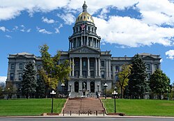
The neighborhood is located just southeast of Denver's Central Business District (CBD) in a well-established residential neighborhood, with commercial centers located along major traffic routes (such as Colfax Avenue and Broadway) and interior arterials (such as East 13th and 14th Avenues). The neighborhood is directly east of the Civic Center neighborhood and the Colorado State Capitol. Over 95% of this neighborhood is developed. The average year of construction for buildings is 1920, with some of the oldest single-family homes in the city. The characteristics of Capitol Hill are closely related to other east Denver neighborhoods, which include the hospital district and the North Capitol Hill neighborhood. Public transportation and city support services are readily available. Neighborhood Boundaries:

Characteristics

Historical population
YearPop.±%
201014,708    
202016,675+13.4%

Capitol Hill is Denver's most densely populated neighborhood. [5] It was once the home of Denver's elite and origination of Foursquare architecture in Denver. Today it consists of historic mansions, apartments and condo buildings. Because of the concentration of multi-family uses and the urban character of the neighborhood, parking is at a premium. The area is strongly influenced by the Colorado State Capitol, which is within its boundaries, and Downtown Denver which is adjacent to the northwest boundary of the neighborhood. Commercial uses are typically located on major arterials such as Colfax Avenue, East 8th Avenue, East 14th Avenue, East 13th Avenue, Lincoln Street and Broadway. A considerable number of mansion properties have been converted to office uses over the past several years due to zoning exemptions offered to historic structures which are zoned for residential uses. Office development in the neighborhood is primarily concentrated in the northwest portion of the neighborhood with small professional offices located throughout the neighborhood.

Arts and culture

The Capitol Hill neighborhood is influenced by its proximity to the Colorado State Capitol, Downtown and its northern boundary, East Colfax Avenue.

Capitol Hill is one of the most cosmopolitan neighborhoods in Denver, well known as a haven for artists and bohemians. There are numerous restaurants, clubs, bars, stores, concert venues, and other cultural amenities in the community. East 13th Avenue is the center of Denver's punk community with various stores that cater to punks and hipsters. Colfax Avenue has a reputation for a wild nightlife with multiple concert venues (The Fillmore Auditorium, The Ogden Theater, The Bluebird Theater, 1Up Colfax), and numerous late-night bars, coffeeshops, restaurants, and stores on the street. During the day, lobbyists and politicians from the Colorado State Capitol can be seen making deals in the restaurants and bars of the neighborhood. The neighborhood also has a reputation for being a very gay and lesbian friendly area of Denver.

Capitol Hill is next to two major Denver parks, Civic Center Park and Cheesman Park. Both of these are meeting centers for the community; they host many festivals, including the Capitol Hill United Neighborhoods-sponsored People's Fair in early June.

Capitol Hill has had a long bohemian reputation with the Colburn Hotel on Grant Street being a onetime residence of Jack Kerouac and Allen Ginsberg.

Attractions

Crime

The crime rate in 2014 in the Capitol Hill neighborhood was 8.63 incidents per 1,000 residents, above average for Denver. [7]

Related Research Articles

<span class="mw-page-title-main">Denver</span> Capital of Colorado, United States

Denver is a consolidated city and county, the capital, and most populous city of the U.S. state of Colorado. Its population was 715,522 at the 2020 census, a 19.22% increase since 2010. It is the 19th-most populous city in the United States and the fifth most populous state capital. It is the principal city of the Denver–Aurora–Lakewood, CO Metropolitan Statistical Area and the first city of the Front Range Urban Corridor.

Colfax Avenue is the main street that runs east–west through the Denver metropolitan area in Colorado. As U.S. Highway 40, it was one of two principal highways serving Denver before the Interstate Highway System was constructed. In the local street system, it lies 15 blocks north of the zero meridian, and would thus otherwise be known as 15th Avenue. The street was named for the 19th-century politician Schuyler Colfax. At just under 50 miles in length, it is known as the "longest continuous commercial street in America."

<span class="mw-page-title-main">Capitol Hill, Seattle</span> Neighborhood in Seattle, Washington, United States

Capitol Hill is a densely populated residential district in Seattle, Washington, United States. One of the city's most popular nightlife and entertainment districts, it is home to a historic gay village and vibrant counterculture community.

<span class="mw-page-title-main">Auraria, Denver</span> Early neighborhood in Denver, Colorado

Auraria was a small mining settlement in the Kansas Territory in the United States. Today it survives in its original location as a neighborhood of Denver, Colorado, south of the confluence of Cherry Creek and the South Platte River.

<span class="mw-page-title-main">Denver Civic Center</span> Neighborhood in Denver, Colorado, USA

The Denver Civic Center is a civic center area that includes two parks surrounded by government and cultural buildings and spaces. Civic Center is located in central Denver, Colorado, on the south side of Downtown Denver. Much of the area is a historic district which was listed on the National Register of Historic Places in 1974. A somewhat smaller area was designated a U.S. National Historic Landmark in 2012 as one of the nation's finest examples of the City Beautiful movement of civic design. Denver Civic Center lies partially within the north end of an official Denver neighborhood also named Civic Center. It includes the Colorado State Capitol building, in the west end of Denver's official Capitol Hill neighborhood, and it includes a few buildings in the south end of Denver's Central Business District.

<span class="mw-page-title-main">Civic Center, Denver (neighborhood)</span> Human settlement in Denver, Colorado, United States of America

Civic Center, Denver is a neighborhood in Denver, Colorado, United States. The northern part of the neighborhood overlaps partially with the Denver Civic Center, an area of parks and civic buildings.

<span class="mw-page-title-main">PrideFest (Denver)</span>

PrideFest is an annual Gay pride event held each June in Denver, honoring the culture and heritage of the lesbian, gay, bisexual, and transgender community in the State of Colorado. The first Denver PrideFest occurred in 1976, the same year the local community center, now known as the Center on Colfax, was founded. The Center organizes and produces the festival and parade each year. The event currently consists of a two-day festival at Civic Center Park, the Pride 5K, and culminates with a parade along Colfax Avenue. Denver PrideFest now draws 525,000 guests annually, making it the third largest pride festival and seventh largest pride parade in the United States.

<span class="mw-page-title-main">Geography of Denver</span> Climate, neighborhoods and infrastructure of Denver

The City and County of Denver, Colorado, is located at 39°43'35" North, 104°57'56" West in the Colorado Front Range region. The Southern Rocky Mountains lie to the west of Denver and the High Plains lie to the east.

<span class="mw-page-title-main">City Park, Denver</span> Park and neighborhood in Colorado, US

City Park is an urban park and neighborhood in Denver, Colorado. The park is 330 acres (1.3 km2) and is located in east-central Denver. The park contains the Denver Zoo, the Denver Museum of Nature and Science, Ferril and Duck Lakes, and a boathouse. City Park is also the name of the neighborhood that contains the park, though the park is the vast majority of the neighborhood. To the immediate north of the park is the City Park Golf Course. City Park is the largest park in Denver.

<span class="mw-page-title-main">Street system of Denver</span>

The oldest part of Denver, Colorado, now the neighborhoods of Auraria Campus, LoDo, much of downtown, and Five Points, is laid out on a grid plan that is oriented diagonal to the four cardinal directions. The rest of the city, including the eastern part of downtown, is laid out primarily on a grid oriented to the cardinal directions. In this larger grid, from east to west, there are generally 16 city blocks per mile, except between Zuni Street and Lowell Boulevard in west Denver. From north to south, there are typically eight blocks per mile, although there are many areas with more blocks per mile. Addresses follow a decimal system, with addresses advancing by one hundred at each cross street.

<span class="mw-page-title-main">Cheesman Park, Denver</span> United States historic place

Cheesman Park is an urban park and neighborhood located in the City and County of Denver, Colorado, United States.

<span class="mw-page-title-main">North Capitol Hill, Denver</span> Neighborhood in Denver, Colorado, United States of America

North Capitol Hill, often referred to as Uptown, is a center city neighborhood near the Colorado State Capitol. The neighborhood has a diverse population, and is similar to surrounding neighborhoods of Five Points and Capitol Hill, in that it cannot be defined by a single demographic. Currently, downtown is undergoing significant redevelopment and gentrification, with many young residents and transplants populating the apartments and homes that frequent the area. North Capitol Hill had a violent crime rate of 13.74 incidents per 1,000 residents in 2014, one of the ten highest rates among Denver neighborhoods. The poverty rate is also much higher than city and national averages, with 34.74% of the population living in poverty. North Capitol Hill is bordered by 20th Ave on the north, Park Ave on the northeast, Downing St on the east, Colfax Ave on the south, and Broadway on the west.

<span class="mw-page-title-main">City Park West, Denver</span> Neighborhood of Denver, Colorado, US

City Park West is a neighborhood of Denver, Colorado. It is a district of mostly single-family homes, small apartment buildings, and one very large hospital complex. The center of the district features the medical facilities of Presbyterian/St. Luke's Hospital, Exempla St. Joseph's Hospital, and a number of other medical office buildings and related facilities. Exempla Saint Joseph's Hospital has embarked on a major expansion project to create the newest, most modern hospital in Colorado. The new facility opened in December 2014.

<span class="mw-page-title-main">Congress Park, Denver</span>

Congress Park is a park and a neighborhood in the City and County of Denver, Colorado, United States. In 2010, the neighborhood had 10,235 residents and 5,724 households.

Speer is the official name for the Denver neighborhood bounded by 7th Avenue (north), Broadway (West), Alameda Avenue (South) and Downing Street (East). The northeast portion northeast of Speer Boulevard is generally referred to as Alamo Placita due to a local park and historic district of this name.

<span class="mw-page-title-main">West Colfax, Denver</span>

West Colfax is a neighborhood of Denver, Colorado. The neighborhood is located in the West Denver area. In 2015 the population of the neighborhood was 9,120, and there were 4,055 housing units.

<span class="mw-page-title-main">Union Station North</span> Neighborhoods in Denver in Colorado, United States

Union Station North, formerly known as Prospect, is a neighborhood within the city limits of Denver, Colorado. Previously dominated by industrial buildings, waste, railroad tracks and considered an area of the city to be avoided, today it has been rehabilitated into multi-story residential buildings, restaurants, amenities, easy access to downtown Denver, and is a short walk to the South Platte River Trail, which runs along its northern boundary.

References

  1. "Census Neighborhood Demographics (2020)". U.S. Census Bureau.
  2. "Official Neighborhood Boundaries" (PDF). Denver.gov. Archived from the original (PDF) on 2006-05-16. Retrieved 2009-05-19.
  3. "Past and present mingle in Denver's Capitol Hill". 9News. October 14, 2016.
  4. "Colorado judicial center, designed to be welcoming, opens next week". 11 December 2012.
  5. Malouff, Dan (March 28, 2013). "What are Colorado's densest neighborhoods?". Denver Urbanism.
  6. Rubino, Joe (June 11, 2018). "California company buys Quiznos, but Denver-born sandwich chain to keep its HQ local, new owner says". The Denver Post.
  7. "Denver Crimes". denvercrimes.com. Retrieved 15 November 2015.

39°44′N104°59′W / 39.733°N 104.983°W / 39.733; -104.983