Captain, Virginia

Last updated
Captain, Virginia
Captain, Virginia - panoramio.jpg
Historical marker in Captain, detailing the history of the town name
USA Virginia location map.svg
Red pog.svg
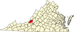
Captain
Location in Virginia
Coordinates: 37°23′32″N080°27′17″W / 37.39222°N 80.45472°W / 37.39222; -80.45472 Coordinates: 37°23′32″N080°27′17″W / 37.39222°N 80.45472°W / 37.39222; -80.45472 [1]
Country United States
State Virginia
County Craig
Elevation
[1]
2,037 ft (621 m)
Time zone UTC-5 (Eastern (EST))
  Summer (DST) UTC-4 (EDT)
ZIP code [2]
24127
Area code 540
GNIS ID [1] 1482318

Captain is an unincorporated community in western Craig County, Virginia, United States. It lies at the intersection of Johns Creek Road and Rocky Gap Trail. [2]

Related Research Articles

<span class="mw-page-title-main">West Virginia</span> U.S. state

West Virginia is a state in the Southern United States. It is bordered by Pennsylvania to the north and east, Maryland to the east and northeast, Virginia to the southeast, Kentucky to the southwest, and Ohio to the northwest. West Virginia is the 10th-smallest state by area and ranks as the 12th-least populous state, with a population of 1,793,716 residents. The capital and largest city is Charleston.

<span class="mw-page-title-main">Craig County, Virginia</span> County in Virginia, United States

Craig County is a county located in the Commonwealth of Virginia. As of the 2020 census, the population was 4,892. Its county seat is New Castle.

<span class="mw-page-title-main">Craig County, Oklahoma</span> County in Oklahoma, United States

Craig County is a county in the U.S. state of Oklahoma. As of the 2010 census, the population was 15,029. Its county seat is Vinita. The county was organized in 1907, shortly before statehood, and named for Granville Craig, a prominent Cherokee farmer who lived in the Bluejacket area.

<span class="mw-page-title-main">Abingdon, Virginia</span> Town in Virginia, United States

Abingdon is a town in Washington County, Virginia, United States, 133 miles (214 km) southwest of Roanoke. The population was 8,376 at the 2020 census. It is the county seat of Washington County. The town encompasses several historically significant sites and features a fine arts and crafts scene centered on the galleries and museums along Main Street.

<span class="mw-page-title-main">Roanoke metropolitan area</span> Metropolitan area in Virginia, United States

The Roanoke Metropolitan Statistical Area is a Metropolitan Statistical Area (MSA) in Virginia as defined by the United States Office of Management and Budget (OMB). The Roanoke MSA is sometimes referred to as the Roanoke Valley, even though the Roanoke MSA occupies a larger area than the Roanoke Valley. It is geographically similar to the area known as the Roanoke Region of Virginia, but while the latter includes Alleghany County, the former does not. As of the 2020 census, the MSA had a population of 315,251.

<span class="mw-page-title-main">Dan River</span> River in the U.S. states of North Carolina and Virginia

The Dan River flows 214 miles (344 km) in the U.S. states of North Carolina and Virginia. It rises in Patrick County, Virginia, and crosses the state border into Stokes County, North Carolina. It then flows into Rockingham County. From there it flows back into Virginia through Pittsylvania County before reentering North Carolina near the border between Caswell County and Rockingham County. It flows into northern Caswell County and then back into southern Virginia and finally into Kerr Reservoir on the Roanoke River.

<span class="mw-page-title-main">Washington metropolitan area</span> Metropolitan area in the United States

The Washington metropolitan area, also sometimes referred to as the National Capital Region or the DMV, is the metropolitan area centered on Washington, D.C. The metropolitan area includes all of Washington, D.C., and parts of Maryland, Virginia, and West Virginia. It is part of the larger Washington–Baltimore combined statistical area.

<span class="mw-page-title-main">Virginia's 3rd congressional district</span> U.S. House district for Virginia

Virginia's third congressional district is a United States congressional district in the Commonwealth of Virginia, serving the independent cities of Norfolk, Newport News, Hampton, Portsmouth, and part of the independent city of Chesapeake. The district is represented by Democrat Bobby Scott. VA-03 is majority-minority and has a plurality Black electorate, and is heavily Democratic.

<span class="mw-page-title-main">2008 United States Senate election in Virginia</span> Election

The 2008 United States Senate election in Virginia was held on November 4, 2008. Incumbent Republican U.S. Senator John Warner decided to retire instead of seeking a sixth term. Democratic former Governor Mark Warner won the open seat by more than 31 percentage points. Warner became the first Democrat to win this seat since 1966. This was also the first time since 1964 that the state voted simultaneously for a Democratic presidential candidate and a Democratic Senate candidate, having voted for Barack Obama in the presidential election, albeit by a far lesser margin. This was Virginia's first open-seat election since 1988.

<span class="mw-page-title-main">Catawba, Virginia</span> Community in Virginia, United States

Catawba is an unincorporated community in the northern section of Roanoke County, Virginia, United States. Catawba occupies the Catawba Valley bound on the south by the north slope of Catawba Mountain and on the north by several mountains which form the border between Roanoke County and Craig County. The primary road through Catawba is State Route 311. Catawba has a post office with the zip code of 24070.

<span class="mw-page-title-main">Paint Bank, Virginia</span> Unincorporated community in Virginia, United States

Paint Bank is an unincorporated community in northern Craig County, Virginia, United States. It is located at the intersection of State Route 18 and State Route 311 northwest of the town of New Castle, the county seat. The village is located between Potts Mountain and Peters Mountain. It is one of the westernmost communities of the Roanoke metropolitan area.

<span class="mw-page-title-main">Maggie, Virginia</span> Unincorporated community in Virginia, United States

Maggie is an unincorporated community in west-central Craig County, Virginia, United States. It lies along Dicks Creek Road.

<span class="mw-page-title-main">Simmonsville, Virginia</span> Unincorporated community in Virginia, United States

Simmonsville is an unincorporated hamlet in southwestern Craig County, Virginia, United States. There are no businesses or services there, only a handful of houses. Simmonsville lies along a T-intersection of State Route 42 and Cumberland Gap Road, 18 miles (29 km) southwest of New Castle.

<span class="mw-page-title-main">National Register of Historic Places listings in Stafford County, Virginia</span>

This is a list of the National Register of Historic Places listings in Stafford County, Virginia.

<span class="mw-page-title-main">National Register of Historic Places listings in Craig County, Virginia</span>

This is a list of the National Register of Historic Places listings in Craig County, Virginia.

<span class="mw-page-title-main">Carol Miller (politician)</span> American politician

Carol Miller is an American farmer and politician who has represented 1st congressional district since 2019. The district, numbered as the 3rd district from 2019 to 2023, covers the southern half of the state, including Huntington, Charleston, Bluefield, and Beckley.

<span class="mw-page-title-main">1980 United States presidential election in Virginia</span> Election in Virginia

The 1980 United States presidential election in Virginia took place on November 4, 1980. All 50 states and the District of Columbia, were part of the 1980 United States presidential election. Virginia voters chose 12 electors to the Electoral College, which selected the president and vice president of the United States.

<span class="mw-page-title-main">2016 United States presidential election in Oklahoma</span> Election in Oklahoma

The 2016 United States presidential election in Oklahoma was held on Tuesday, November 8, 2016, as part of the 2016 United States presidential election in which all 50 states plus the District of Columbia participated. Oklahoma voters chose electors to represent them in the Electoral College via a popular vote, pitting the Republican Party's nominee, businessman Donald Trump, and running mate Indiana Governor Mike Pence against Democratic Party nominee, former Secretary of State Hillary Clinton, and her running mate Virginia Senator Tim Kaine. Oklahoma has seven electoral votes in the Electoral College.

<span class="mw-page-title-main">2020 United States presidential election in West Virginia</span> Election in West Virginia

The 2020 United States presidential election in West Virginia was held on Tuesday, November 3, 2020, as part of the 2020 United States presidential election in which all 50 states plus the District of Columbia participated. West Virginia voters chose electors to represent them in the Electoral College via a popular vote, pitting the Republican Party's nominee, incumbent President Donald Trump, and running mate Vice President Mike Pence against Democratic Party nominee, former Vice President Joe Biden, and his running mate California Senator Kamala Harris. West Virginia has five electoral votes in the Electoral College.

References

  1. 1 2 3 "Feature Detail Report: Captain (Craig County, Virginia)". Geographic Names Information System . United States Geological Survey, United States Department of the Interior . Retrieved July 19, 2008.
  2. 1 2 Captain, Virginia (Map). Google Maps. Retrieved July 19, 2008.