
St Ives is a seaside town, civil parish and port in Cornwall, England, United Kingdom. The town lies north of Penzance and west of Camborne on the coast of the Celtic Sea. In former times it was commercially dependent on fishing. The decline in fishing, however, caused a shift in commercial emphasis, and the town is now primarily a popular seaside resort, notably achieving the title of Best UK Seaside Town from the British Travel Awards in both 2010 and 2011. St Ives was incorporated by Royal Charter in 1639. St Ives has become renowned for its number of artists. It was named best seaside town of 2007 by The Guardian newspaper.
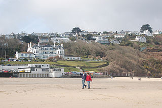
Carbis Bay is a seaside resort and village in Cornwall, England. It lies 1 mile (1.6 km) southeast of St Ives, on the western coast of St Ives Bay, on the Atlantic coast. The South West Coast Path passes above the beach.

St Erth is a civil parish and village in Cornwall, England, United Kingdom.

The St Ives Bay Line is a 4.25 miles (6.84 km) railway line from St Erth to St Ives in Cornwall, England, United Kingdom. It was opened in 1877, the last new 7 ft broad gauge passenger railway to be constructed in the country. Converted to standard gauge in 1892, it continues to operate as a community railway, carrying tourists as well as local passengers. It has five stations including the junction with the Cornish Main Line at St Erth.

St Ives is a parliamentary constituency covering the western end of Cornwall and the Isles of Scilly. The constituency has been represented in the House of Commons of the UK Parliament since 2015 by Derek Thomas, a Conservative MP.

Hayle is a port town and civil parish in west Cornwall, England, United Kingdom. It is situated at the mouth of the Hayle River and is approximately seven miles (11 km) northeast of Penzance.

Liskeard railway station serves the town of Liskeard in Cornwall, England. The station is approximately 18 miles (29 km) west of Plymouth on the Cornish Main Line and 264 miles 71 chains (426.3 km) from London Paddington via Box and Plymouth Millbay. It is the junction for the Looe Valley Line. The railway station is situated approximately 0.5 miles (0.80 km) south-west of Liskeard town centre.

St Austell station is a Grade II listed station which serves the town of St Austell, Cornwall, England. It is 286 miles 26 chains from the zero point at London Paddington measured via Box and Plymouth Millbay. The station is operated by Great Western Railway.
Redruth station serves the town of Redruth, Cornwall, United Kingdom, and is situated on the Cornish Main Line between Truro and Camborne. The station is 309 miles 68 chains from the zero point at London Paddington measured via Box and Plymouth Millbay.
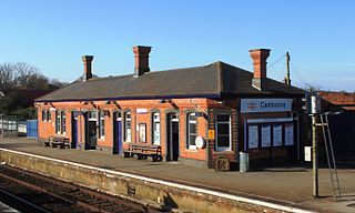
Camborne railway station serves the town of Camborne, Cornwall, England. The station is 313 miles 40 chains from the zero point at London Paddington measured via Box and Plymouth Millbay.

Hayle railway station serves the small town of Hayle, Cornwall, United Kingdom. Great Western Railway manage the station and operate most train services.

St Erth railway station is a Grade II listed station situated at Rose-an-Grouse in Cornwall, United Kingdom. It serves the nearby village of St Erth, which is about 0.75 miles (1.21 km) away, and is the junction for the St Ives Bay Line to St Ives. The station is 320 miles 78 chains from the zero point at London Paddington measured via Box and Plymouth Millbay.

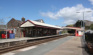
St Ives railway station is a railway station which serves the coastal town of St Ives, Cornwall, England. It was opened in 1877 as the terminus of the last new broad gauge passenger railway to be constructed in the country. Converted to standard gauge in 1892, it is today served by Great Western Railway services on the St Ives Bay Line from St Erth.

Lelant railway station is on the waterfront of the Hayle estuary below the village of Lelant in Cornwall, United Kingdom.

Lelant Saltings railway station was opened on 27 May 1978 to provide a park and ride facility for visitors to St Ives, Cornwall, England. It is situated on the A3074 road close to the junction with the A30 near the foot of the hill up to Lelant village. The park and ride facility closed in June 2019, replaced by a new one at nearby St Erth railway station, but the Saltings station remains open with a very limited service of trains.

Lelant is a village in west Cornwall, England, UK. It is on the west side of the Hayle Estuary, about 2+1⁄2 miles (4.0 km) southeast of St Ives and one mile (1.6 km) west of Hayle. The village is part of St Ives civil parish, the Lelant and Carbis Bay ward on Cornwall Council, and also the St Ives Parliamentary constituency. The birth, marriage, and death registration district is Penzance. Its population at the 2011 census was 3,892 The South West Coast Path, which follows the coast of south west England from Somerset to Dorset passes through Lelant, along the estuary and above Porth Kidney Sands.

The St. Ives Times and Echo is an independent, weekly local newspaper based in St Ives, Cornwall, England, United Kingdom.

St Ives Bay is a bay on the Atlantic coast of north-west Cornwall, England, United Kingdom. It is in the form of a shallow crescent, some 4 miles or 6 km across, between St Ives in the west and Godrevy Head in the east.
Ludgvan was an electoral division of Cornwall in the United Kingdom which returned one member to sit on Cornwall Council between 2009 and 2021. It was abolished at the 2021 local elections, being split between Ludgvan, Madron, Gulval and Heamoor, Long Rock, Marazion and St Erth, St Ives East, Lelant and Carbis Bay, and St Ives West and Towednack.

St Ives East was an electoral division of Cornwall in the United Kingdom which returned one member to sit on Cornwall Council from 2013 to 2021. It was abolished at the 2021 local elections, being succeeded by St Ives West and Towednack and St Ives East, Lelant and Carbis Bay.

