
Carbis Bay is a seaside resort and village in Cornwall, England. It lies 1 mile (1.6 km) southeast of St Ives, on the western coast of St Ives Bay, on the Atlantic coast. The South West Coast Path passes above the beach.

The Looe Valley Line is an 8+3⁄4-mile (14 km) community railway from Liskeard to Looe in Cornwall, England, that follows the valley of the East Looe River for much of its course. It is operated by Great Western Railway.

The St Ives Bay Line is a 4.25 miles (6.84 km) railway line from St Erth to St Ives in Cornwall, England, United Kingdom. It was opened in 1877, the last new 7 ft broad gauge passenger railway to be constructed in the country. Converted to standard gauge in 1892, it continues to operate as a community railway, carrying tourists as well as local passengers. It has five stations including the junction with the Cornish Main Line at St Erth.

Hayle is a port town and civil parish in west Cornwall, England, United Kingdom. It is situated at the mouth of the Hayle River and is approximately seven miles (11 km) northeast of Penzance.

Bodmin Parkway railway station is on the Cornish Main Line that serves the nearby town of Bodmin and other parts of mid-Cornwall, England. It is situated 3 miles (4.8 km) south-east of the town of Bodmin in the civil parish of St Winnow, 274 miles 3 chains from London Paddington measured via Box and Plymouth Millbay. Network Rail’s National Rail Timetable dated May 2023 records the distance from London Paddington to Bodmin Parkway as 252.50 miles.

Truro railway station serves the city of Truro, Cornwall, England. The station is 300 miles 63 chains from the zero point at London Paddington measured via Box and Plymouth Millbay. It is situated on the Cornish Main Line and is the junction for the Maritime Line to Falmouth Docks.
Redruth station serves the town of Redruth, Cornwall, United Kingdom, and is situated on the Cornish Main Line between Truro and Camborne. The station is 309 miles 68 chains from the zero point at London Paddington measured via Box and Plymouth Millbay.
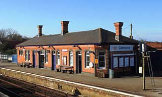
Camborne railway station serves the town of Camborne, Cornwall, England. The station is 313 miles 40 chains from the zero point at London Paddington measured via Box and Plymouth Millbay.

St Erth railway station is a Grade II listed station situated at Rose-an-Grouse in Cornwall, United Kingdom. It serves the nearby village of St Erth, which is about 0.75 miles (1.21 km) away, and is the junction for the St Ives Bay Line to St Ives. The station is 320 miles 78 chains from the zero point at London Paddington measured via Box and Plymouth Millbay.

Looe railway station serves the twin towns of East and West Looe, in Cornwall, England. The station is the terminus of the scenic Looe Valley Line 8.75 miles (14 km) south of Liskeard. It faces out across the estuary of the River Looe.

St Ives railway station is a railway station which serves the coastal town of St Ives, Cornwall, England. It was opened in 1877 as the terminus of the last new broad gauge passenger railway to be constructed in the country. Converted to standard gauge in 1892, it is today served by Great Western Railway services on the St Ives Bay Line from St Erth.

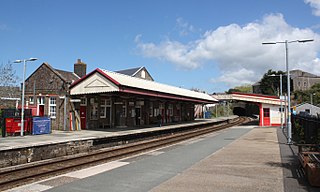
Carbis Bay railway station is on the St Ives Bay Line in Cornwall, England, United Kingdom and serves the village and beach of Carbis Bay, a community that only adopted this name after the arrival of the railway in 1877. Carbis Viaduct is situated on the St Ives (west) side of the station.

Lelant Saltings railway station was opened on 27 May 1978 to provide a park and ride facility for visitors to St Ives, Cornwall, England. It is situated on the A3074 road close to the junction with the A30 near the foot of the hill up to Lelant village. The park and ride facility closed in June 2019, replaced by a new one at nearby St Erth railway station, but the Saltings station remains open with a very limited service of trains.

Lelant is a village in west Cornwall, England, UK. It is on the west side of the Hayle Estuary, about 2+1⁄2 miles (4.0 km) southeast of St Ives and one mile (1.6 km) west of Hayle. The village is part of St Ives civil parish, the Lelant and Carbis Bay ward on Cornwall Council, and also the St Ives Parliamentary constituency. The birth, marriage, and death registration district is Penzance. Its population at the 2011 census was 3,892 The South West Coast Path, which follows the coast of south west England from Somerset to Dorset passes through Lelant, along the estuary and above Porth Kidney Sands.
The West Cornwall Railway was a railway company in Cornwall, Great Britain, formed in 1846 to construct a railway between Penzance and Truro. It purchased the existing Hayle Railway, and improved its main line, and built new sections between Penzance and Hayle, and between Redruth and Truro, and opened throughout in 1852.
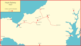
The Hayle Railway was an early railway in West Cornwall, constructed to convey copper and tin ore from the Redruth and Camborne areas to sea ports at Hayle and Portreath. It was opened in 1837, and carried passengers on its main line from 1843.
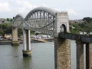
The Cornish Main Line is a railway line in Cornwall and Devon in the United Kingdom. It runs from Penzance to Plymouth, crossing from Cornwall into Devon over the famous Royal Albert Bridge at Saltash.
There are seventeen disused railway stations on the Cornish Main Line between Plymouth in Devon and Penzance in Cornwall, England. The remains of nine of these can be seen from passing trains. While a number of these were closed following the so-called "Beeching Axe" in the 1960s, many of them had been closed much earlier, the traffic for which they had been built failing to materialise.

St Ives Bay is a bay on the Atlantic coast of north-west Cornwall, England, United Kingdom. It is in the form of a shallow crescent, some 4 miles or 6 km across, between St Ives in the west and Godrevy Head in the east.

The Helston Railway is a heritage railway in Cornwall which aims to rebuild and preserve as much as possible of the former GWR Helston Railway between Nancegollen and Water-Ma-Trout on the outskirts of Helston. It is operated by the Helston Railway Preservation Company using members of the Helston Railway Preservation Society.

