Castle and Lands of Auchruglen

Last updated

Auchruglen Castle
Newmilns, East Ayrshire, Scotland
Auchruglen at Greenholm Map, William Johnson, 1828. East Ayrshire.jpg
Auchruglen on an 1828 Map
East Ayrshire UK location map.svg
Red pog.svg
Auchruglen Castle
Coordinates 55°36′10″N4°19′28″W / 55.602718°N 4.3244500°W / 55.602718; -4.3244500
Grid reference grid reference NS5365436797
Type Tower
Site information
OwnerPrivate
Controlled by Clan Nesbitt and Clan Campbell
Open to
the public
No
ConditionDemolished
Site history
Built16th century
MaterialsStone

The Castle and Lands of Auchruglen (NS5365436797) was a peel tower in the old district of Kyle held at different times by the Nesbitt and Campbell Clans and located near Newmilns, Parish of Galston, East Ayrshire, Scotland.

Contents

History

A wide variety of alternative spellings of the castle's name are recorded, such as Achruglen, [1] Auchenruglane, [2] Achinruglan, [3] and Achinrugglan, [4] John Smith's survey of sites states that Auchruglen Tower was located in the Galston district, held by the Kennedy's, but its exact site is uncertain. [5]

Gallow Law Covenanter Memorial James Smith Covenanter Memorial, Gallow Law, Molmont Hill, East Ayrshire. Detail.jpg
Gallow Law Covenanter Memorial

In 1775 the castle is not recorded on Andrew Armstrong's map however an 'Auchen' is marked. [6] James Paterson recorded that Archruglen was an old tower, the remains of which were still visible and well known in 1866, located on a steep eminence on the banks of the River Irvine. [1] James Paterson states that the castle was a property of the Campbells of Loudoun, but not their principal residence. [1] Craufuird Loudoun states that Auchruglen was a square peel tower that lay between High Dalloy and Crosstrees Farms and had been built around 1527, [7] not as a formidable fortress, but as a keep, a place of refuge, built for the purposes of protection and shelter under the circumstances of a sudden emergency. [8]

Gallow Law Cairn lies above the castle's location and it is said to have been the site of a barony court hangings in feudal times. [9] A Gallow Hill Cairn in 1926 was built by local miners to the memory of the Covenanter James Smith of Threepwood, who died for civil and religious liberty in 1684. [9]

Lairds and tenants of Auchruglen

Possible site of Auchruglen Castle on the highest point to the right, above the glen and Crosstrees Farm Auchruglen Castle site and Glen, Newmilns, East Ayrshire.jpg
Possible site of Auchruglen Castle on the highest point to the right, above the glen and Crosstrees Farm

It is not clear whether a Barony of Auchruglen existed. The property lay in Kyle which although associated with lowland clans such as the Kennedys was at the time also a stronghold of the Campbells. [10] James Nesbit (1457 to 1514) was granted sasine of Greenholm near Newmilns, Auchenruglane and Sorn as heir to his father in 1496. [2] In 1607 Margaret Nisbet daughter of Alexander Nisbet of Greenholm was the spouse of Hugh Campbell of Auchruglen.[ citation needed ] In 1607 Elizabeth Gordon was the wife of Matthew Campbell of Batreshill and Hew Campbell of Auchruglen was their eldest son.[ citation needed ] In 1578 Mariota Nisbet and her mother were heir portioner who had in 1553 sold Auchinrugland to Hugh Campbell. The 40s lands of Auchinruglane during the years 1536 up to 1550 were in the care of whoever had the wardship of the two Nisbet daughters.[ citation needed ] Margaret Donald was born in Auchruglen on 8 Dec 1774 to Mary Millar. [11]

A John Campbell of 'Newmilns' was taken with several 'Lollards of Kyle', mostly minor lairds, to trial as a Lollard, the earliest Scottish Protestants, and was executed. It is not clear if he was a Campbell of Auchruglen. [12]

Nicol Brown Esq held the £100 land of Auchruglen in 1803 after the death of John Brown (1729-1802), as recorded in the Land Tax Rolls. [13] [14]

Burning of Auchruglen Castle

Sauchie, a typical Scottish Tower Castle Sauchie Tower. Detail view south-East. Clackmannanshire.jpg
Sauchie, a typical Scottish Tower Castle

Paterson states that the Kennedys destroyed Auchruglen Castle [1] in revenge for the murder of the Earl of Cassilis at Prestwick in 1527 by Hugh Campbell of Loudoun and his followers. The Kennedys made repeated forays into Campbell lands, however no record of the destruction of the castle has been found in the criminal records of the time. [1] Many versions exist of the ballad of 'Adam of Gordon and his Men' regarding the 1571 burning of Towie Castle first published by Lord Hailes. One version, long known in the district, refers to the burning of Loudoun Castle. [1] In past times wandering minstrels would alter ballads to fit in with incidents at locations they were visiting. [1] [15] Craufuird Loudoun considered that the burning of Lady Loudoun and her children took place at the 'Auld Place' otherwise known as Arclowdun Castle on the Hag Burn near the existing Loudoun Castle. [7]

William Robertson recorded that local tradition was that the Campbell's keep of 'Achruglen' was burned, together with Lady Loudoun and her children who the Kennedy's had discovered to be at this keep rather than at Loudoun Castle itself. [16] [7] The Scottish Statistical Account of 1845 relates that Achruglen Tower was burned by the Kennedys. [17]

The writer of the 1845 Statistical Account states that the old castle is supposed to have been destroyed by fire about 350 years before, making the event in around 1500. [18]

Edom o Gordon or Adam of Gordon [19]

"It was in and about the Martinmas time,
When the wind blew schill and cauld,
That Adam o Gordon said to his men,
Whare will we get a hauld?

'Do ye not see yon bonnie castell,
That stands on Loudon lee?
The lord and I hae a deadlie feed,
And his lady fain wuld I see.

Lady Campbell was standing in the close,
A preenin o her goun,
Whan Adam o Gordon and his men
Cam riding thro Galston toun.

The dinner was na weel set doun,
Nor yet the grace weel said,
Till Adam o Gordon and a' his men
Around the wa's war laid.

'Come doun, come down, Ladie Campbell,' he said,
'Come doun and speak to me;
I'll kep thee in a feather bed,
And thy warraner I will be.

'I winna come doun and speak to thee,
Nor to ony lord nor loun;
Nor yet to thee, thou bloody butcher,
The laird o Auchruglen toun.

'Come doun, come doun, Ladye Campbell,' he said,
'Cum doun and speak to me;
I'll kep thee on the point o my sword,
And thy warraner I will be.

'I winna come doun and speak to thee,
Nor to ony lord or loun,
Nor yet to thee, thou bludie butcher,
The laird o Auchruglen toun."

This section of a version of the old ballad implies that the attacker was the Laird of Auchruglen. [19]

Auchruglin

Crosstrees Farm and the Auchruglin Glen Crosstrees Farm, Auchruglin Glen, Newmilns, East Ayrshire.jpg
Crosstrees Farm and the Auchruglin Glen

A dwelling, rather than a castle, 'Auchruglen' is shown between Windyhill and Corsstree, later Crosstree on John Thomson's map of 1832 [20] The location does not appear to match with the description of the tower as being on an eminence. The 1843-1882 OS map records a dwelling, Auchruglin, located close to the Auchruglin Glen (NS534363) on the west side of the burn. [21] A footbridge over the burn connects this property to farms in the district, such as High Dalloy. [21] By 1895 this property was abandoned, but still named and had been linked by a lane to Crosstrees. [22] Thomas Gebbie of Auchruglen had a single horse recorded in the Farm Tax Rolls 1797–1798. [23] Scotlands Places records Auchruglen was a Cottage, rather than a farm, occupied by a Hugh McInnes and in 1855-57 was the Property of Thomas Brown Esqr Lanfine. [24]

The Auchruglin Burn rises East of the Trig [Trigonometrical] Station on Gallow law and flows passed Auchruglin High and Laigh Dalloy before having its confluence with the Irvine Water. [25]

Cartographic evidence

Gordon's map of 1636-52 shows an Achinruglan Castle [3] The castle is clearly indicated on an eminence in the old district of Kyle, a short distance from the River Irvine. Timothy Pont and Joan Blaeu's map of 1560-1614 clearly shows the castle of Achinrugglan on the east bank of then Achinrugglan Burn above Dalluy, now Dalloy Farm. [4] Achinrugglan is recorded below Momout, now Molmont Hill and to the east of a water course, on Herman Moll's Ayrshire map of 1745 [26] William Roys 1750s map does not show the castle. An 'Auchen' is marked on the Andrew Armstrong map of 1775. [6] Later maps do not indicate a castle or tower however an 'Auchruglen' is shown between Windyhill and Corsstree, later Crosstree on John Thomson's map of 1832. [20] Lidar mapping suggests a structure close to Mount Pleasant and Crosstrees Farms. [27]

Historical timeline

1496 - James Nesbit (1457 to 1514) was granted sasine of Greenholm, Auchenruglane and Sorn as heir to his father. [2]

1527 circa - The Kennedys are by tradition said to have destroyed Auchruglen Castle by burning [1] in revenge for the murder of the Earl of Cassilis at Prestwick. [1]

1536 to 1550 - The 40s lands of Auchinruglane were in the care of whoever had the wardship of the two Nisbet daughters.[ citation needed ]

1553 - Mariota Nisbet and her mother had in 1553 sold Auchinrugland to Hugh Campbell.[ citation needed ]

1607 - Margaret Nisbet daughter of Alexander Nisbet of Greenholm was the spouse of Hugh Campbell of Auchruglen.[ citation needed ]

1607 - Elizabeth Gordon was the wife of Matthew Campbell of Batreshill and Hew Campbell of Auchruglen was their eldest son.[ citation needed ]

1636-52 - Gordon's map of 1636-52 records the location of an Achinruglan Castle. [3]

1560-1614 - Timothy Pont and Joan Blaeu's map clearly shows the castle of Achinrugglan on the east bank of then Achinrugglan Burn above Dalloy Farm. [4]

1745 - Achinrugglan is recorded below Molmont Hill and to the east of a water course, on Herman Moll's Ayrshire map. [26] This is the last clear recording of a castle of that name.

1774 - Margaret Donald was born in Auchruglen on 8 December to Mary Millar. [11]

1775 - An 'Auchen' is marked on the Andrew Armstrong map on the west side of the Auchruglin Burn. [6]

1797-1798 - Thomas Gebbie of Auchruglen had a single horse recorded in the Farm Tax Rolls. [23]

1803 - Nicol Brown Esq held the £100 land of Auchruglen after the death of John Brown (1729-1802).

1832 - A dwelling, rather than a castle, 'Auchruglen' is shown between Windyhill and Crosstree farms, later Crosstree on John Thomson's map. [20]

1845 - The Statistical Account states that the old castle is supposed to have been destroyed by fire about 350 years before, making the event in around 1500. [18]

1843-1882 - The first OS map records a dwelling, Auchruglin, located close to the Auchruglin Glen (NS534363) on the west side of the burn. [21]

1855-1857 - Auchruglen was a Cottage, rather than a farm, occupied by a Hugh McInnes and was the Property of Thomas Brown Esqr Lanfine. [24]

1895 - The Auchruglin property was abandoned, but still named and had been linked by a lane to Crosstrees. [22]

Related Research Articles

<span class="mw-page-title-main">Ayrshire</span> Historic county in Scotland

Ayrshire is a historic county and registration county, in south-west Scotland, located on the shores of the Firth of Clyde. The lieutenancy area of Ayrshire and Arran covers the entirety of the historic county as well as the island of Arran, formerly part of the historic county of Buteshire. Its principal towns include Ayr, Kilmarnock and Irvine and it borders the counties of Renfrewshire and Lanarkshire to the north-east, Dumfriesshire to the south-east, and Kirkcudbrightshire and Wigtownshire to the south. Like many other counties of Scotland, it currently has no administrative function, instead being sub-divided into the council areas of East Ayrshire, North Ayrshire and South Ayrshire. It has a population of approximately 366,800.

Loudoun is a parish in East Ayrshire, Scotland and lies between five and ten miles east of Kilmarnock. The parish roughly encompasses the northern half of the Upper-Irvine Valley and borders Galston Parish at the River Irvine.

<span class="mw-page-title-main">Newmilns</span> Burgh (Newmilns and Greenholm) and Village in Scotland

Newmilns is a village in the burgh of Newmilns and Greenholm, in East Ayrshire, Scotland. It has a population of 3,057 people and lies on the A71, around seven miles east of Kilmarnock and twenty-five miles southwest of Glasgow. It is situated in a valley through which the River Irvine runs and, with the neighbouring towns of Darvel and Galston, forms an area known as the Upper Irvine Valley.

<span class="mw-page-title-main">Galston, East Ayrshire</span> Municipality in Scotland

Galston is a municipality in East Ayrshire, Scotland, which has a population of 5,001 (2001) and is at the heart of the civil parish of the same name. It is situated in wooded countryside four miles upriver from Kilmarnock and is one a group of the small towns located in the Irvine Valley between the towns of Hurlford and Newmilns. To the north of the town is the ruin of Loudoun Castle, the site of Loudoun Castle theme park from 1995 to 2010. In 1874 the population was 4,727.

<span class="mw-page-title-main">River Irvine</span> River in southwest Scotland

The River Irvine is a river that flows through southwest Scotland. Its watershed is on the Lanarkshire border of Ayrshire at an altitude of 810 feet (250 m) above sea-level, near Loudoun Hill, Drumclog, and 7 miles SW by W of Strathaven. It flows 29+12 mi (47.5 km) westward, dividing the old district of Cunninghame from that of Kyle, until it reaches the sea via Irvine Harbour in the form of the Firth of Clyde, and flows into Irvine Bay by the town of Irvine. It has many tributaries, some of which form parish, district and other boundaries.

<span class="mw-page-title-main">Murdoch Nisbet</span>

Murdoch Nisbet was a Scottish notary public in the diocese of Glasgow who created one of the earliest Bible translations into Scots. Living in the parish of Loudoun, Ayrshire, Nisbet's work as a notary public brought him into contact with local religious dissidents. He participated in a conventicle where he illicitly conducted readings of his translation. In 1539, Nisbet "digged and built a Vault in the Bottom of his own House" to hide his New Testament manuscript and conventicle activities.

<span class="mw-page-title-main">Craigie Castle</span>

Craigie Castle, in the old Barony of Craigie, is a ruined fortification situated about 4 miles (6.4 km) southeast of Kilmarnock and 1 mile (1.6 km) southeast of Craigie village, in the Civil Parish of Craigie, South Ayrshire, Scotland. The castle is recognised as one of the earliest buildings in the county. It lies about 1.25 miles (2 km) west-south-west of Craigie church. Craigie Castle is protected as a scheduled monument.

<span class="mw-page-title-main">Castle and Barony of Robertland</span>

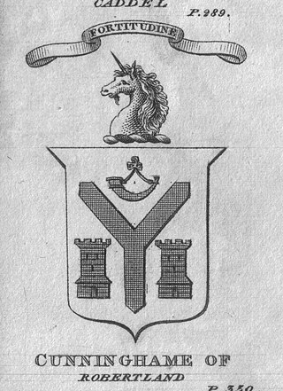
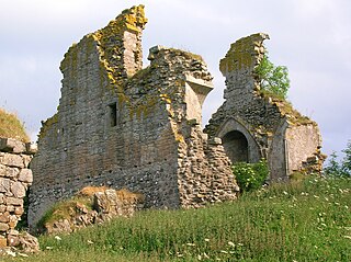
The Castle and Barony of Robertland is located near Stewarton, off the B769 road, in the old district of Cunninghame, Parish of Stewarton, and now part of East Ayrshire, Scotland.

<span class="mw-page-title-main">Fail Monastery</span> Former monastery in Ayrshire, Scotland

Fail Monastery, occasionally known as Failford Abbey, had a dedication to 'Saint Mary', and was located at Fail on the bank of the Water of Fail, Parish of Tarbolton near the town of Tarbolton, South Ayrshire. Most of the remaining monastery ruins were removed in 1952. The official and rarely used title was House of the Holy Trinity of Failford or the Ministry of Failford.

<span class="mw-page-title-main">Terringzean Castle, East Ayrshire</span>

Terringzean Castle, also Taringzean, pronounced 'Tringan', is a Category B listed castle ruin lying above the River Lugar and the Terringzean Holm in the policies of Dumfries House, Parish of Cumnock, Scotland. The name Craufordstone or Craufurdstoun, has also been used, echoing that it and these lands originally belonged to the Crawfords, as did Lefnoreis Castle or Lochnorris Castle which once stood near the site of the Dumfries House stables.

<span class="mw-page-title-main">Loch of Trabboch</span> Drained freshwater loch in East Ayrshire, Scotland

The Loch of Trabboch or Dalrympleston Loch (NS440211) was situated in a low-lying area below the old Castle of Trabboch, once held by the Boyd family in the Parish of Stair, East Ayrshire, Scotland.

Trabboch Castle is a ruined L-plan tower house in the old Barony of Trabboch, Parish of Stair, East Ayrshire, Scotland.

<span class="mw-page-title-main">Loch Fergus</span> Freshwater loch in South Ayrshire, Scotland

Loch Fergus is a freshwater post-glacial "Kettle Hole" sometimes recorded as Fergus Loch. It is quite visible and is situated in a low-lying area close to the B742 road between the farms and dwellings of Trees, Lochfergus and Bowmanston in the Parish of Ayr, South Ayrshire, Scotland. The loch lies to the north of Martnaham Loch, four miles east-southeast of Ayr. It drains to the southwest into the Snipe Loch.

<span class="mw-page-title-main">Polkelly Castle</span>

Polkelly Castle, also Pokelly, was an ancient castle located near Fenwick, at NS 4568 4524, in the medieval free Barony of Polkelly, lying north of Kilmarnock, Parish of Fenwick, East Ayrshire, Scotland. The castle is recorded as Powkelly (c1747), Pockelly (c1775), Pow-Kaillie, Ponekell, Polnekel, Pollockelly, Pollockellie, Pokellie, Pothelly, Pathelly Ha' and Polkelly. The name is given circa 1564 as Powkellie when it was held by the Cunninghams of Cunninghamhead.

<span class="mw-page-title-main">Auchenbathie Tower</span>

Auchenbathie, Auchinbathie Tower or rarely Barcraigs Tower is a ruined fortification, a tower house, once held by the Wallace Clan of Elderslie, situated in Renfrewshire, Parish of Lochwinnoch, Scotland. The spelling used varies greatly and "Auchenbathie" will be used here as the standard spelling. The pronunciation locally is "Auchenbothy", the same as a Victorian mansion in Kilmacolm; no connection is known.

<span class="mw-page-title-main">Auchencloigh Castle</span> Ruined fortification in the Parish of Ochiltree, East Ayrshire, Scotland

Auchencloigh Castle or Auchincloigh Castle is a ruined fortification near the Burnton Burn, lying within the feudal lands of the Craufurd Clan, situated in the Parish of Ochiltree, East Ayrshire, Scotland.

<span class="mw-page-title-main">Montfode Castle</span>

The remains of the old castle of Montfode or Monfode lie to the north-west of the town of Ardrossan and 1.5 miles (2.4 km) south-west of West Kilbride in North Ayrshire, Scotland, above the Montfode Braes, in the old Barony of Kilbride. The remains of the 16th century tower are protected as a scheduled monument. The castle ruins are clearly visible from the A78 Ardrossan bypass.

<span class="mw-page-title-main">Kingencleugh Castle</span>

The remains of the old castle of Kingencleugh or Kingenclough lies close to east of the town of Mauchline, East Ayrshire, in the old Barony of Mauchline off the A76. The castle is Category B listed.

Galston Parish is situated in East Ayrshire, Scotland, some five to ten miles east of Kilmarnock and roughly encompasses the southern half of the Upper Irvine Valley. The parish shares strong links with the parish of Loudoun, with which it shares a border along the River Irvine.

The Lands of Dallars or Auchenskeith (NS463337) form a small estate in East Ayrshire, Hurlford, Kilmarnock, Parish of Riccarton, Scotland. The present mansion house is mainly late 18th-century, located within a bend of the Cessnock Water on the site of older building/s. "Dullers or Dillers" was changed to "Auchenskeith" or "Auchinskeigh" (sic) as well as other variants and then the name reverted nearer to the original form as "Dollars" and then finally "Dallars". Dallars lies 3.25 km south of Hurlford.

References

Notes
  1. 1 2 3 4 5 6 7 8 9 Paterson, James (1866). History of the Counties of Ayr and Wigton. James Stillie. p. 541.
  2. 1 2 3 "Nisbet of Greenholm".
  3. 1 2 3 "View map: Cuningham [sic]. Cunningham. - Manuscript maps by Robert & James Gordon, ca.1636-1652". maps.nls.uk.
  4. 1 2 3 https://maps.nls.uk/view/00000419 Timothy Pont, 1560-1614? Blaeu, Joan, 1596-1673. Coila Provincia, Kyle.
  5. Smith, John (1895). Prehistoric Man in Ayrshire. Elliot Stock. p. 104.
  6. 1 2 3 "View map: A new map of Ayrshire... - Counties of Scotland, 1580-1928". maps.nls.uk.
  7. 1 2 3 Loudoun, Craufuird. A History of the House of Loudoun and Associated Families. Craufuird C Loudoun. p. 27.
  8. "Ayrshireroots - The Raid of Loudoun".
  9. 1 2 "Gallow Law, Hillend | Canmore". canmore.org.uk.
  10. Rollie, James (1895). The Invasion of Ayrshire Cancelled. James Rollie. p. 56.
  11. 1 2 "Margaret Donald, born 1774 - Ancestry®". www.ancestry.co.uk.
  12. Rollie, James (1895). The Invasion of Ayrshire Cancelled. James Rollie. p. 61.
  13. "E106/4/5/17 | ScotlandsPlaces". scotlandsplaces.gov.uk.
  14. "Sasine Index" (PDF).
  15. "Glenbuchat Heritage - 50 Massacre at Corgarff or Towie Castle 1571". www.glenbuchatheritage.com.
  16. Robertson, William (1908). Ayrshire. Its History and Historic Families. Vol.2. Dunlop and Drennan. p. 220.
  17. "Statistical Accounts of Scotland". stataccscot.edina.ac.uk.
  18. 1 2 Child, Francis James (18 January 2005). "English and Scottish ballads. Ed. by Francis James Child".
  19. 1 2 Child, Francis James. "The English and Scottish Popular Ballads" via Wikisource.
  20. 1 2 3 "View map: Northern Part of Ayrshire. Southern Part. - John Thomson's Atlas of Scotland, 1832". maps.nls.uk.
  21. 1 2 3 "Explore georeferenced maps - Map images - National Library of Scotland". maps.nls.uk.
  22. 1 2 "View map: Ayrshire XXIV.2 (Galston) - Ordnance Survey 25 inch 2nd and later editions, Scotland, 1892-1949". maps.nls.uk.
  23. 1 2 "E326/10/1/155 | ScotlandsPlaces". scotlandsplaces.gov.uk.
  24. 1 2 "OS1/3/28/84 | ScotlandsPlaces". scotlandsplaces.gov.uk.
  25. "OS1/3/28/16 | ScotlandsPlaces". scotlandsplaces.gov.uk.
  26. 1 2 "View map: The South Part of the Shire of Air [i.e. Ayr], containing Kyle and Carrick / by... - Maps by Herman Moll". maps.nls.uk.
  27. "Side by side georeferenced maps viewer - Map images - National Library of Scotland". maps.nls.uk.
Sources and further reading
  1. Adamson, Archibald R. (1879). Rambles through the Land of Burns. Kilmarnock : Dunlop & Drennan.
  2. Campbell, Thorbjørn (2003). Ayrshire. A Historical Guide. Edinburgh : Birlinn. ISBN   1-84158-267-0
  3. Coventry, Martin (2010). Castles of the Clans. Musselburgh : Goblinshead. ISBN   1-899874-36-4
  4. Davis, Michael C. (1991). The Castles and Mansions of Ayrshire. Ardrishaig : Spindrift Press
  5. Love, Dane (2003). Ayrshire : Discovering a County. Ayr : Fort Publishing. ISBN   0-9544461-1-9.
  6. Paterson, James (1863–66). History of the Counties of Ayr and Wigton. V. 2 - Part 2 - Kyle. Edinburgh: J. Stillie.
  7. Smith, John (1895). Prehistoric Man in Ayrshire. London : Elliot Stock.