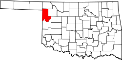
Catesby, Oklahoma

Last updated
Catesby, Oklahoma
Unincorporated community
USA Oklahoma location map.svg
Red pog.svg
Catesby
Location within the state of Oklahoma
Usa edcp location map.svg
Red pog.svg
Catesby
Catesby (the US)
Coordinates: 36°29′35″N99°57′46″W / 36.49306°N 99.96278°W / 36.49306; -99.96278 Coordinates: 36°29′35″N99°57′46″W / 36.49306°N 99.96278°W / 36.49306; -99.96278
Country United States
State Oklahoma
County Ellis
Time zone Central (CST) (UTC-6)
  Summer (DST) CDT (UTC-5)
This Methodist Church is one of the few buildings in Catesby. None of the town's original buildings still stand. Catesby Oklahoma Church.jpg
This Methodist Church is one of the few buildings in Catesby. None of the town's original buildings still stand.

Catesby is an unincorporated community located in Ellis County, Oklahoma. Named for Catesby ap Roger Jones, the town was founded on July 1, 1902. The post office was opened by Ella M. Rose on February 18, 1902. The town remains a legal town site, although the post office was closed on January 1, 1970.

Unincorporated area Region of land not governed by own local government

In law, an unincorporated area is a region of land that is not governed by a local municipal corporation; similarly an unincorporated community is a settlement that is not governed by its own local municipal corporation, but rather is administered as part of larger administrative divisions, such as a township, parish, borough, county, city, canton, state, province or country. Occasionally, municipalities dissolve or disincorporate, which may happen if they become fiscally insolvent, and services become the responsibility of a higher administration. Widespread unincorporated communities and areas are a distinguishing feature of the United States and Canada. In most other countries of the world, there are either no unincorporated areas at all, or these are very rare; typically remote, outlying, sparsely populated or uninhabited areas.

Ellis County, Oklahoma County in the United States

Ellis County is a county located on the western border of the U.S. state of Oklahoma. As of the 2010 census, the population was 4,151, making it the fifth-least populous county in Oklahoma. Its county seat is Arnett.

Catesby ap Roger Jones United States Navy officer

Catesby ap Roger Jones was an officer in the U.S. Navy who became a commander in the Confederate Navy during the American Civil War. He assumed command of CSS Virginia during the Battle of Hampton Roads and engaged the USS Monitor in the historic first battle of the two iron clads.

As of the centennial in 2002, there were two residents, making it the smallest townsite in Oklahoma.

Sources

Shirk, George H.; Oklahoma Place Names; University of Oklahoma Press; Norman, Oklahoma; 1987: ISBN   0-8061-2028-2 .

International Standard Book Number Unique numeric book identifier

The International Standard Book Number (ISBN) is a numeric commercial book identifier which is intended to be unique. Publishers purchase ISBNs from an affiliate of the International ISBN Agency.


Related Research Articles

Agra, Oklahoma Town in Oklahoma, United States

Agra is a town in northern Lincoln County, Oklahoma, United States. The population was 339 at the 2010 census. An early real estate developer coined the town's name from the word "agriculture".

Idabel, Oklahoma City in Oklahoma, United States

Idabel is a city in and county seat of McCurtain County, Oklahoma, United States. The population was 7,010 at the 2010 census. It is located in the southeast corner of Oklahoma, a tourist area known as Kiamichi Country.

Inola, Oklahoma Town in Oklahoma, United States

Inola is a town in Rogers County, Oklahoma, United States. It is included in the Tulsa Metropolitan Statistical Area (TMSA). The population was 1,788 at the 2010 census, a 12.5 percent increase from 1,589 at the 2000 census. Inola is a Cherokee word meaning "Black Fox." The town styles itself as "The Hay Capital of the World." It is now considered a bedroom community for Tulsa.

Fort Supply, Oklahoma Town in Oklahoma, United States

Fort Supply is a town in Woodward County, Oklahoma, United States, 13 kilometres (8.1 mi) northwest of the city of Woodward, Oklahoma, the county seat. The population was 330 at the 2010 census.

Robert Catesby English conspirator

Robert Catesby was the leader of a group of provincial English Catholics who planned the failed Gunpowder Plot of 1605.

Ashby St Ledgers village in United Kingdom

Ashby St Ledgers is a village in the Daventry district of Northamptonshire, England. The post town is Rugby in Warwickshire. The population of the civil parish at the 2011 census was 173. The Manor House is famous for being a location for the planning of the Gunpowder Plot in 1605.

Lower Catesby village in United Kingdom

Lower Catesby is a hamlet in the civil parish of Catesby, Northamptonshire, about 4 miles (6.4 km) southwest of Daventry. Lower Catesby is beside the nascent River Leam, which rises about 1 mile (1.6 km) to the south in the parish of Hellidon. The Jurassic Way long-distance footpath passes through Lower Catesby. The population of the hamlet is included in the civil parish of Hellidon.

Midlothian, Oklahoma Unincorporated community in Oklahoma, United States

Midlothian is a small unincorporated community in Lincoln County, Oklahoma. The post office was established in 1902 and the town plat filed in 1904. The post office closed in 1919 and the school was consolidated with the Chandler School District in the 1940s.

Wardville, Oklahoma Unincorporated community in Oklahoma, United States

Wardville is a small unincorporated community in northern Atoka County, Oklahoma, United States, along State Highway 131 14 miles northeast of Coalgate, Oklahoma. The post office was established February 6, 1902 under the name Herbert, Oklahoma. The town was named after Herbert Ward, who was the youngest son of the towns first postmaster, Henry Pleasant Ward. The name of the town was changed to Wardville on July 18, 1907. Wardville was named for the before mentioned Henry Pleasant Ward, who served in the territorial House of Representatives and Senate and was an Atoka County judge. The Wardville Post Office closed in 2007.

Hext, Oklahoma Unincorporated community in Oklahoma, United States

Hext is a small unincorporated rural community on old U.S. Highway 66 in Beckham County, Oklahoma, United States. The town was named after a local resident, William Hext.

Meers, Oklahoma Unincorporated community in Oklahoma, United States

Meers is a small unincorporated community located on State Highway 115 in Comanche County, Oklahoma, in the foothills of the Wichita Mountains. Founded as a gold mining town in 1901, it was named for mine operator Andrew J. Meers. The only remaining structure of the original town is the Meers Store & Restaurant, which Food Network named as the best hamburger joint in Oklahoma & one of the best in the United States of America, largely due to its signature MeersBurger. The Meers Store also served as the area post office from March 12, 1902, until February, 1989. Currently, area residents have Lawton mailing addresses. Meers lies on the Meers Fault. In 1985, in order to monitor seismic activity, the Oklahoma Geological Survey installed a seismograph in the Meers Store. The Meers Store was listed on the National Register of Historic Places in 1978 as Meers Mining Camp, since it was the only surviving relic of the community's gold rush days.

Eagle City, Oklahoma Unincorporated community in Oklahoma, United States

Eagle City is a small rural community located on State Highway 58 in western Blaine County, Oklahoma, United States. Established on the Frisco Line before statehood, the post office was named Dillon. The Dillon Post Office opened July 26, 1902. The name was changed to Eagle City September 4, 1909. The ZIP Code is 73658.

Adamson is a ghost town in Pittsburg County, Oklahoma, United States. Comprising 4 square miles, it was located between McAlester and Wilburton. The town contained 15 coal mines. Four mines were major producers. The post office was established on March 1, 1906. The town was named for Peter Adamson, a mine owner.It was a prosperous coal mining town before and during World War I, especially during 1913 to 1919. On September 4, 1914, Adamson was the site of one of the worst coal mine disasters in the United States. The town never recovered economically, and is now considered a ghost town. It has since been largely engulfed by Eufaula Lake.

Parkland, Oklahoma unincorporated community in Oklahoma, United States

Parkland is a ghost town in northern Lincoln County, Oklahoma, United States. It is 4 miles (6 km) south of Agra, Oklahoma. Its name was adopted "to describe the character of the townsite". It still exists as a small community.

Avery, Oklahoma Ghost town in Oklahoma, United States

Avery is a ghost town in Lincoln County, Oklahoma, United States. The community had a post office from September 16, 1902, until August 26, 1957. Founded as Mound City, it was renamed for Eastern Oklahoma Railway worker Avery Turner after the railroad built through the community.

Catoctin in Yavapai County, Arizona was a small gold mining camp. The camp was established around 1902 and received a post office on December 29 of the same year. It is located on upper Hassayampa River, sixteen miles southeast of Prescott, Arizona. Only a handful of mining buildings and homes were constructed and on average the town was home to about twenty people. The Catoctin and Climax mines were nearby. On July 15, 1920 the post office was closed.

Cerbat, Arizona Ghost Town in Arizona, United States

Cerbat is a ghost town just west of the Cerbat Mountains in Mohave County, Arizona. Mining in the area began in the late 1860s and a camp was established soon after. Cerbat was built in a canyon 38 miles (61 km) from Hardyville, Arizona. The town was prosperous and contained several mining and public buildings along with cabins for over 100 settlers, as well as a school, a doctor's office and a lawyer's office. In the 1870s the town was connected by dirt road to Fort Rock, Camp Hualapai and Prescott, Arizona. Cerbat was the third seat of Mohave County until 1877 when Mineral Park took the title.

Yewed, Oklahoma Unincorporated community in Oklahoma, United States

Yewed is an unincorporated community in Alfalfa County, Oklahoma, United States. Yewed is 0.7 miles (1.1 km) east of Lambert.

Charles Gasham "Gristmill" Jones was an American urban developer and politician in the U.S. state of Oklahoma. Jones was responsible for bringing electrical power to downtown Oklahoma City and developing a railroad line between Sapulpa, Oklahoma, and Oklahoma City. The town of Jones, Oklahoma, is named for him.

Cairo, Oklahoma Unincorporated community in Oklahoma, United States

Cairo is a small unincorporated community in Coal County, Oklahoma. It is 7 miles northeast of Coalgate, Oklahoma. The community was named after the town of Cairo, Illinois. A post office operated in Cairo from March 28, 1902 to July 15, 1939.