Caw Fell

Last updated

Caw Fell
Caw Fell.jpg
Caw Fell from the ridge leading up from Ennerdale
Highest point
Elevation 697 m (2,287 ft)
Prominence c. 22 m
Parent peak Haycock
Listing Wainwright, Nuttall
Coordinates 54°29′10″N3°20′35″W / 54.486°N 3.343°W / 54.486; -3.343 Coordinates: 54°29′10″N3°20′35″W / 54.486°N 3.343°W / 54.486; -3.343
Geography
Lake District National Park UK relief location map.png
Red triangle with thick white border.svg
Caw Fell
Location in the Lake District
Location relief map Borough of Copeland.svg
Red triangle with thick white border.svg
Caw Fell
Location in Copeland Borough
Location Cumbria, England
Parent range Lake District, Western Fells
OS grid NY132109
Topo map OS Landranger 89, 90, Explorer OL4, OL6
Listed summits of Caw Fell
NameGrid refHeightStatus
Iron Crag NY123119 640 m (2,099 ft)Hewitt

Caw Fell is a fell in the English Lake District, standing between Haycock the Lank Rigg group. It occupies a wide upland area with Ennerdale to the north and Blengdale to the south. Caw Fell is distant from any point of access by Lakeland standards, but can be climbed from Blengdale or Bowness Knott car-parks.

Contents

Topography

The Western Fells occupy a triangular sector of the Lake District, bordered by the River Cocker to the north east and Wasdale to the south east. Westwards the hills diminish toward the coastal plain of Cumberland. At the central hub of the high country are Great Gable and its satellites, while two principal ridges fan out on either flank of Ennerdale, the western fells in effect being a great horseshoe around this long wild valley. [1] Caw Fell stands on the southern arm.

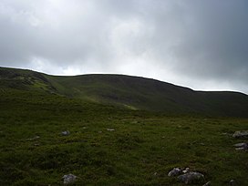
The main watershed runs broadly westwards from Great Gable, dividing the headwaters of Ennerdale and Wasdale. The main fells in this section are Kirk Fell, Pillar, Scoat Fell, Haycock and Caw Fell. The surrounding valleys gradually diverge until at Caw Fell they are 6 miles apart and other rivers spring up to drain the intervening country. The Bleng rises to the south of Caw Fell, while Worm Gill drains the western slopes. The fell is therefore the end of the westerly run of the ridge, and the watershed curves north around the head of Worm Gill, crossing the subsidiary top of Iron Crag on the transit to Crag Fell and Lank Rigg.

The unnamed col connecting Caw Fell to Haycock is flat topped and carries the Ennerdale Fence, in this section a substantial dry stone wall. Tongue Gill, the principal headwater of the Bleng, flows from the southern side of the saddle while on the opposite side is the steep headwall of Silver Cove, a deeply enclosed side-valley running into Ennerdale. The heathery spur of Tongue End runs parallel to the east.

West of the summit a broad ridge descends steeply to Worm Gill, a craggy bowl scooped out on the northern side above the tributary of Bleaberry Gill. Running due north between this corrie and Silver Cove is the ridge of Iron Crag, making the whole summit area resemble an inverted 'T' in plan. A narrow and steep sided col at 1,575 ft provides Iron Crag with considerably more prominence than its parent, a small tarn lying on the northern slope. The rock face giving Iron Crag its name overlooks Silver Cove, but is not particularly prominent. From this top the ridge swings west again, the rough northern flanks running above the shore of Ennerdale Water. The main features here are Mart Knott, Stair Knott and Boat How. The ridge now meets the headwaters of the River Calder and divides to embrace the valley, Crag Fell to the north and Lank Rigg to the south.

Caw Fell also has a lower level south west ridge, running down between the River Bleng and Worm Gill. This descends first to Stockdale Moor, a site littered with tumuli, hut circles, enclosures and other remnants of ancient habitation. [1] Beyond are the low hills centred on Ponsonby Fell (1,033 ft), not included by Alfred Wainwright in his influential Pictorial Guide to the Lakeland Fells , but covered by other guidebooks. [2]

Geology

The north eastern flanks are overlain by drift deposits with the plagioclase-phyric andesite lavas of the Birker Fell Formation beneath. The rest of the fell exhibits rock of the Ennerdale Intrusion, granophyric granite. [3]

Iron Crag Mine operated below the crag of that name from around 1864 to 1896. 500 tons of haematite ore was raised in 1881, but the mine never proved a commercial success. Other smaller operations ran briefly in Silver Cove and Deep Gill. [4]

Summit

The top stands to the north of the wall, marked by a cairn. Caw Fell is remote from higher fells and gives an all round panorama of the Western Fells and the Scafells. It is necessary to cross the wall to take in the full view. [1]

Ascents

The south west ridge over Stockdale Moor can be followed from the car park at Bleng Bridge, this being over five miles each way. From Bowness Knott in Ennerdale, Caw Fell can be reached in a similar distance via the Tongue End spur. Indirect ascents can be made via Grike and Crag Fell from the Kinniside Stone Circle. [1] [2]

Related Research Articles

Pillar (Lake District) Mountain in the English Lake District, Cumbria, England

Pillar is a mountain in the western part of the English Lake District. Situated between the valleys of Ennerdale to the north and Wasdale to the south, it is the highest point of the Pillar group. At 892 metres (2,927 feet) it is the eighth-highest mountain in the Lake District. The fell takes its name from Pillar Rock, a prominent feature on the Ennerdale side, regarded as the birthplace of rock climbing in the district.

Great Gable Mountain in the United Kingdom

Great Gable is a mountain in the Lake District, United Kingdom. It is named after its appearance as a pyramid from Wasdale, though it is dome-shaped from most other directions. It is one of the most popular of the Lakeland fells, and there are many different routes to the summit. Great Gable is linked by the high pass of Windy Gap to its smaller sister hill, Green Gable, and by the lower pass of Beck Head to its western neighbour, Kirk Fell.

Buckbarrow

Buckbarrow is a small fell in the English Lake District overlooking the western end of Wastwater. It is featured in Alfred Wainwright’s Pictorial Guide to the Lakeland Fells and is given a height of 1,410 ft approximately; however, the Ordnance Survey and other guidebooks now give an altitude of 423 m (1,388 ft). The fell’s name means ‘The hill of the buck or goat’. It is derived either from the Old English word bucc meaning buck or the Old Norse word bokki meaning a male goat.

Kirk Fell

Kirk Fell is a fell in the Western part of the English Lake District. It is situated between Great Gable and Pillar on the long ring of fells surrounding the valley of Ennerdale, and also stands over Wasdale to the south. However, it is separated from its two higher neighbours by the low passes of Black Sail and Beck Head, giving it a high relative height and making it a Marilyn, the thirteenth highest in the Lake District.

Seatallan

Seatallan is a mountain in the western part of the English Lake District. It is rounded, grassy and fairly unassuming, occupying a large amount of land. However, it is classed as a Marilyn because of the low elevation of the col connecting it to Haycock, its nearest higher neighbour to the north. The name Seatallan is believed to have a Cumbric origin, meaning "Aleyn's high pasture".

Mellbreak

Mellbreak is a hill in the Western part of the English Lake District. Despite being surrounded on all sides by higher fells, it stands in isolation. It is surrounded on three sides by a "moat" of deep marshy land, and on the east side by the lake of Crummock Water. The fell forms a partnership with the lake, running parallel to it, falling sheer into it, and regularly providing the backdrop for pictures of it.

Base Brown Fell in England

Base Brown is a fell in England's Lake District, near the head of the Borrowdale Valley. It forms one side of the Seathwaite Valley, and on the western side it is flanked by the hanging valley of Gillercomb.

Red Pike (Buttermere) Mountain in the English Lake District, Cumbria, England

Red Pike is a fell in the High Stile range in the western English Lake District, which separates Ennerdale from the valley of Buttermere and Crummock Water. It is 2,476 ft (755 m) high. The direct ascent of Red Pike from Buttermere is very popular and the ridge walk from Red Pike to Haystacks is regarded as one of the finest in the area, with excellent views of the Scafells, Great Gable and Pillar.

Red Pike (Wasdale) Mountain in the English Lake District, Cumbria, England

Red Pike is a fell in the English Lake District. It is 826 m or 2,709 ft (826 m) high and lies due north of Wast Water. It is often climbed as part of the Mosedale Horseshoe, a walk which also includes Pillar.

Scoat Fell Mountain in the English Lake District, Cumbria, England

Scoat Fell is a fell in the western part of the English Lake District. It stands at the head of the Mosedale Horseshoe with its back to Ennerdale. Paths lead to Scoat Fell from Ennerdale over Steeple, from Wasdale over Red Pike, and along the ridge from Pillar.

Green Gable

Green Gable is a fell in the English Lake District often traversed by walkers en route to its more famous neighbour Great Gable. It can be ascended from Honister Pass, Seathwaite in Borrowdale, or Ennerdale. There are good views of Gable Crag, Scafell Pike and the Buttermere valley from the summit.

Yewbarrow Mountain in the English Lake District, Cumbria, England

Yewbarrow is a fell, in the English Lake District, which lies immediately north of the head of Wast Water. It is 628 metres high and in shape resembles the upturned hull of a boat or a barrow. Yewbarrow is on the left in the classic view of Great Gable and Wast Water.

Haycock (Lake District) Fell in the Lake District, Cumbria, England

Haycock is a mountain in the western part of the English Lake District. It rises between Scoat Fell and Caw Fell to the south of Ennerdale and the north of Wasdale. Haycock is an imposing dome-shaped fell, its popularity with walkers diminished somewhat by its remoteness. It can be climbed from either valley and offers fine mountain views.

Grike (Lake District)

Grike is a hill in the west of the English Lake District, near Ennerdale Water. It is part of the Lank Rigg group, the most westerly Wainwright as the fells diminish toward the coastal plain. It can be climbed from Kinniside or Ennerdale Bridge.

Brandreth Fell in the Lake District, Cumbria, England

Brandreth is a fell in the English Lake District. It stands between Great Gable and Haystacks in the Western Fells.

Crag Fell

Crag Fell is a hill in the English Lake District. It is part of the Lank Rigg group, standing above Ennerdale Water in the Western Fells. The craggy northern face above the lake gives the fell its name, prominent in views from the car park at Bowness Knott. Ascents are commonly made from the foot of Ennerdale Water.

Lank Rigg

Lank Rigg is a fell in the English Lake District. It stands to the south of Ennerdale in the Western Fells. A sprawling hill with gentle grassy slopes it can be climbed from various points on the Coldfell road. It carries various remains from ancient habitation.

Middle Fell is a hill or fell in the English Lake District. It is a satellite of Seatallan standing above the northern shore of Wastwater. Middle Fell can be climbed from Greendale near the foot of Wastwater, and a fine view of the lake backed by the Wastwater Screes is visible from the summit.

Iron Crag

Iron Crag is a mountain in the English Lake District, standing between Crag Fell and Caw Fell. The name of the fell is the source of some confusion, as the summit is unnamed on Ordnance Survey maps. Iron Crag apparently refers to the rocky outcrop below the summit, while the lower slopes are referred to as Ennerdale Fell. The Western aspect of the lower slopes, facing Ennerdale Water is known as The Side.

Western Fells

The Western Fells are a group of hills in the English Lake District. Centred on Great Gable they occupy a triangular area between Buttermere and Wasdale. The Western Fells are characterised by high ridges and an abundance of naked rock.

References

  1. 1 2 3 4 Alfred Wainwright: A Pictorial Guide to the Lakeland Fells, Volume 7 The Western Fells: Westmorland Gazette (1966): ISBN   0-7112-2460-9
  2. 1 2 Bill Birkett: Complete Lakeland Fells: Collins Willow (1994): ISBN   0-00-713629-3
  3. British Geological Survey: 1:50,000 series maps, England & Wales Sheet 29: BGS (1999)
  4. Adams, John: Mines of the Lake District Fells: Dalesman (1995) ISBN   0-85206-931-6