Green Gable

Last updated

Green Gable
GreatAndGreenGables.jpg
Great and Green Gable from Sprinkling Tarn. Green Gable is the smaller hump on the right.
Highest point
Elevation 801 m (2,628 ft)
Prominence c.50 m
Parent peak Great Gable
Listing Hewitt, Wainwright, Nuttall
Coordinates 54°29′08″N3°12′53″W / 54.48553°N 3.21476°W / 54.48553; -3.21476
Geography
Lake District National Park UK relief location map.png
Red triangle with thick white border.svg
Green Gable
Location relief map United Kingdom Allerdale.svg
Red triangle with thick white border.svg
Green Gable
Location in Allerdale, Cumbria
Location relief map Borough of Copeland.svg
Red triangle with thick white border.svg
Green Gable
Location in Copeland, Cumbria
Location Cumbria, England
Parent range Lake District, Western Fells
OS grid NY214107
Topo map OS Landrangers 89, 90, ExplorerOL4

Green Gable is a fell in the English Lake District often traversed by walkers en route to its more famous neighbour Great Gable. It can be ascended from Honister Pass, Seathwaite in Borrowdale, or Ennerdale. There are good views of Gable Crag, Scafell Pike and the Buttermere valley from the summit.

Contents

Topography

The Western Fells occupy a triangular sector of the Lake District, bordered by the River Cocker to the north east and Wasdale to the south east. Westwards the hills diminish toward the coastal plain of Cumberland. At the central hub of the high country are Great Gable and its satellites, while two principal ridges fan out on either flank of Ennerdale, the western fells in effect being a great horseshoe around this long wild valley. [1] Green Gable stands to the north east of its mightier sibling.

Green and Great Gable rise at the head of Ennerdale, the infant River Liza tumbling down from their connecting col, Windy Gap. To their backs they have the walkers' pass of Sty Head, connecting Borrowdale to Wasdale. Green Gable has a footing in Borrowdale only, standing to the north of the pass. It is from Ennerdale that the fell achieves a peaked "gabled" outline, although only the lower slopes could be considered green- the summit area being a desert of stones.

Taking Great Gable as the pivot of the Western Fells, the northward arm begins over Green Gable, before swinging round over Brandreth and Haystacks to begin the long northern wall of Ennerdale. Green Gable also has a secondary ridge to the north east, culminating in the separate fell of Base Brown.

Sourmilk Gill Sourmilk Gill, Seathwaite.JPG
Sourmilk Gill

Windy Gap (2,460 ft) stands a little way to the south west of the summit, at the bottom of a stony slope. On the Ennerdale side is Stone Cove- not named by chance, they are yards deep [1] - while the south eastern descent leads down Aaron Slack. "Slack" is the dialect word for scree, [1] and this too is a rough chute leading down to Sty Head Pass. Sty Head Tarn lies at the bottom of the Slack, a large pool in a scooped out hollow, the outlet blocked by boulders. It is 30 ft deep and reputed to contain trout. [2]

Green Gable's eastern face contains the slight hollow of Mitchell Cove, its stream joining Styhead Gill on the way to Borrowdale. At the northern corner is the ridge to Base Brown, the flat topped depression of Blackmoor Pots. The dale between the Base Brown and Brandreth ridges is Gillercomb, a classic hanging valley. Its stream, Sourmilk Gill, exits around the nose of Base Brown via a series of cascades to Seathwaite. This ensures that all of Green Gable's waters, bar those from the western face, reach the River Derwent. Brandreth connects via the narrow ridge of Gillercomb Head, site of a few small pools after wet weather. The Ennerdale side provides the gentlest slopes, at least at lower levels, with the long grassy spur of Tongue gradually rising up the fell. The topmost section however is guarded by Greengable Crags, stretching around from Stone Cove.

Geology

Summit of Green Gable, from the Great Gable path - showing rough track down to Windy Gap. Windy Gap - geograph.org.uk - 39756.jpg
Summit of Green Gable, from the Great Gable path - showing rough track down to Windy Gap.

The summit of Green Gable is overlain by till, although there are outcrops of the Long Top Member to the west and north. This comprises bedded and welded rhyolitic tuff and lapilli-tuff. Above Sty Head there are examples of Scafell dacite and the tuffs and breccias of the Lingmell Formation. [3] There is no history of mining on the fell. [4]

Looking NW from Green Gable summit down the Ennerdale valley. Ennerdale.JPG
Looking NW from Green Gable summit down the Ennerdale valley.

Summit

Green Gable has a neat summit marked by a cairn and would be a famous spot in its own right but for the looming presence of Great Gable. The summit is the perfect position from which to admire Gable Crag, and in all other directions is undiminished in its view of the Lakeland fells. The view up the Buttermere valley is perhaps the highlight. [1]

Ascents

Some of the routes are those used for Great Gable, in particular those from the north. From Seathwaite a path runs up beside Sour Milk Gill into Gillercomb. From here it continues up the flank of the Blackmoor Pols ridge and onto the summit. From the top of the Honister Pass road a contouring path runs around Grey Knotts and Brandreth, before ascending Green Gable via Gillercomb Head. This path can also be used to access Moses Trod, a high level route from Honister to Wasdale. "Moses" was a possibly apocryphal figure in local stories, a quarryman from Honister who doubled as a trader-cum-whisky smuggler between the Lakeland valleys.

A route from Seathwaite not designed for the ascent of Great Gable can be found by climbing up Styhead pass and then branching off into Mitchell Cove, following the beck almost to the summit. Aaron Slack can also be used. If starting from Ennerdale a long walk up the valley can culminate in either a climb up Stone Cove to Windy Gap, or a slightly easier ascent of the Tongue to reach Gillercomb Head. Indirect climbs via Brandreth or Base Brown are also possible. [1] [5]

Related Research Articles

<span class="mw-page-title-main">Pillar (Lake District)</span> Mountain in the English Lake District, Cumbria, England

Pillar is a mountain in the western part of the English Lake District. Situated between the valleys of Ennerdale to the north and Wasdale to the south, it is the highest point of the Pillar group. At 892 metres (2,927 ft) it is the eighth-highest mountain in the Lake District. The fell takes its name from Pillar Rock, a prominent feature on the Ennerdale side, regarded as the birthplace of rock climbing in the district.

<span class="mw-page-title-main">Great Gable</span> Mountain in the United Kingdom

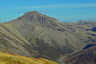
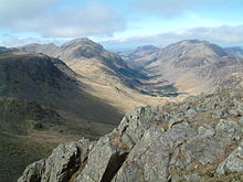
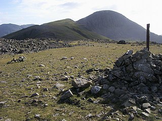
Great Gable is a mountain in the Lake District, United Kingdom. It is named after its appearance as a pyramid from Wasdale, though it is dome-shaped from most other directions. It is one of the most popular of the Lakeland fells, and there are many different routes to the summit. Great Gable is linked by the high pass of Windy Gap to its smaller sister hill, Green Gable, and by the lower pass of Beck Head to its western neighbour, Kirk Fell.

<span class="mw-page-title-main">Great End</span> Mountain in the Lake District, England

Great End is the most northerly mountain in the Scafell chain, in the English Lake District. From the south it is simply a lump continuing this chain. From the north, however, it appears as an immense mountain, with an imposing north face rising above Sprinkling Tarn (lake). This is a popular location for wild camping, and the north face attracts many climbers.

<span class="mw-page-title-main">Dale Head</span>

Dale Head is a fell in the north-western sector of the Lake District, in northern England. It is 753 metres or 2,470 feet above sea level and stands immediately north of Honister Pass, the road between Borrowdale and Buttermere.

<span class="mw-page-title-main">Haystacks (Lake District)</span> Fell in the Lake District, Cumbria, England

Haystacks, or Hay Stacks, is a hill in England's Lake District, situated at the south-eastern end of the Buttermere Valley. Although not of any great elevation, Haystacks has become one of the most popular fells in the area. This fame is partly due to the writings of Alfred Wainwright, who espoused its attractions and chose it as the place where he wanted his ashes scattered. Its large, undulating summit contains many rock formations, tarns and hidden recesses.

<span class="mw-page-title-main">High Stile</span> Fell in the Lake District, Cumbria, England

High Stile is a mountain in the western part of the Lake District in North West England. It is the eleventh-highest English Marilyn, standing 807 metres (2,648 ft) high, and has a relative height of 362 metres (1,187 ft).

<span class="mw-page-title-main">Kirk Fell</span>

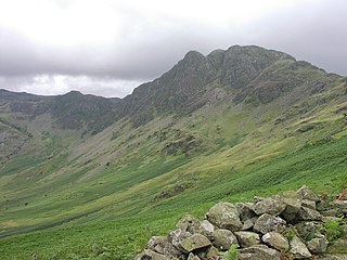
Kirk Fell is a fell in the Western part of the English Lake District. It is situated between Great Gable and Pillar on the long ring of fells surrounding the valley of Ennerdale, and also stands over Wasdale to the south. However, it is separated from its two higher neighbours by the low passes of Black Sail and Beck Head, giving it a high relative height and making it a Marilyn, the thirteenth highest in the Lake District.

<span class="mw-page-title-main">Fleetwith Pike</span>

Fleetwith Pike is a fell in the English Lake District in the county of Cumbria which reaches a height of 648 metres. The fell is a well-known feature of the area as it casts an imposing presence over Buttermere and the Honister Pass on the B5289 motor road between Borrowdale and Buttermere.

<span class="mw-page-title-main">Base Brown</span> Fell in England

Base Brown is a fell in England's Lake District, near the head of the Borrowdale Valley. It forms one side of the Seathwaite Valley, and on the western side it is flanked by the hanging valley of Gillercomb.

<span class="mw-page-title-main">Seathwaite Fell</span> Fell in the Lake District, Cumbria, England

Seathwaite Fell is an area of the Lake District in Cumbria, England. It stands above the hamlet of the same name at the head of Borrowdale.

<span class="mw-page-title-main">Red Pike (Buttermere)</span> Mountain in the English Lake District, Cumbria, England

Red Pike is a fell in the High Stile range in the western English Lake District, which separates Ennerdale from the valley of Buttermere and Crummock Water. It is 2,476 ft (755 m) high. The direct ascent of Red Pike from Buttermere is very popular and the ridge walk from Red Pike to Haystacks is regarded as one of the finest in the area, with excellent views of the Scafells, Great Gable and Pillar.

<span class="mw-page-title-main">Red Pike (Wasdale)</span> Mountain in the English Lake District, Cumbria, England

Red Pike is a fell in the English Lake District. It is 826 m or 2,709 ft (826 m) high and lies due north of Wast Water. It is often climbed as part of the Mosedale Horseshoe, a walk which also includes Pillar.

<span class="mw-page-title-main">High Crag</span>

High Crag stands at the southern end of the High Stile ridge which divides the valleys of Ennerdale and Buttermere in the west of the English Lake District. It is often climbed as part of a popular ridge walk, from Black Sail youth hostel, or from Buttermere via Scarth Gap. Panoramas of the Great Gable and the Scafells are visible.

<span class="mw-page-title-main">Scoat Fell</span> Mountain in the English Lake District, Cumbria, England

Scoat Fell is a fell in the western part of the English Lake District. It stands at the head of the Mosedale Horseshoe with its back to Ennerdale. Paths lead to Scoat Fell from Ennerdale over Steeple, from Wasdale over Red Pike, and along the ridge from Pillar.

<span class="mw-page-title-main">Yewbarrow</span> Mountain in the English Lake District, Cumbria, England

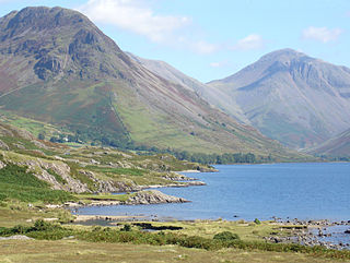
Yewbarrow is a fell, in the English Lake District, which lies immediately north of the head of Wast Water. It is 628 metres high and in shape resembles the upturned hull of a boat or a barrow. Yewbarrow is on the left in the classic view of Great Gable and Wast Water.

<span class="mw-page-title-main">Grey Knotts</span> Fell in the Lake District, Cumbria, England

Grey Knotts is a fell in the English Lake District. It is situated one kilometre south of the B5289 road as it crosses the Honister Pass. It is well seen from mid-Borrowdale as it rises above Seatoller. Grey Knotts reaches a height of 697 metres (2287 feet) and is part of a ridge which ascends from the woodland behind Seatoller and continues south-west and then south for four kilometres to Great Gable. The fell's name really only applies to the summit rocks, but has been adopted for the entire fell with the high ground in this area, locally known as Seatoller Fell on Ordnance Survey maps.

<span class="mw-page-title-main">Brandreth</span> Fell in the Lake District, Cumbria, England

Brandreth is a fell in the English Lake District. It stands between Great Gable and Haystacks in the Western Fells.

<span class="mw-page-title-main">Southern Fells</span>

<span class="mw-page-title-main">Western Fells</span>

The Western Fells are a group of hills in the English Lake District. Centred on Great Gable they occupy a triangular area between Buttermere and Wasdale. The Western Fells are characterised by high ridges and an abundance of naked rock.

References

  1. 1 2 3 4 5 Alfred Wainwright: A Pictorial Guide to the Lakeland Fells, Volume 7 The Western Fells: Westmorland Gazette (1966): ISBN   0-7112-2460-9
  2. Blair, Don: Exploring Lakeland Tarns: Lakeland Manor Press (2003): ISBN   0-9543904-1-5
  3. British Geological Survey: 1:50,000 series maps, England & Wales Sheet 29: BGS (1999)
  4. Adams, John: Mines of the Lake District Fells: Dalesman (1995) ISBN   0-85206-931-6
  5. Birkett, Bill: Complete Lakeland Fells: Collins Willow (1994): ISBN   0-00-218406-0