
Gwinnett County is located in the north central portion of the U.S. state of Georgia. It forms part of the Atlanta metropolitan area. In 2020, the population was 957,062, making it the second-most populous county in Georgia. Its county seat is Lawrenceville. The county is named for Button Gwinnett, one of the signatories of the Declaration of Independence.

Buford is a city in Gwinnett and Hall counties in the U.S. state of Georgia. As of the 2020 census, the city had a population of 17,144. Most of the city is in Gwinnett County, which is part of the Atlanta-Sandy Springs-Marietta Metropolitan Statistical Area. The northern sliver of the city is in Hall County, which comprises the Gainesville, Georgia Metropolitan Statistical Area and is part of the larger Atlanta-Athens-Clarke-Sandy Springs Combined Statistical Area.

Grayson is a city in Gwinnett County, Georgia, United States. The 2020 estimated population of Grayson, GA is 4740 people. The population was 2,666 at the 2010 census, up from 765 in 2000.

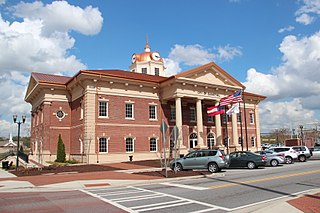
Lawrenceville is a city in and the county seat of Gwinnett County, Georgia, United States. It is a suburb of Atlanta, located approximately 30 miles (50 km) northeast of downtown. As of the 2020 census, the population of Lawrenceville was 30,629. In 2019, the U.S. Census Bureau estimated the city population to be 30,834.

Lilburn is a city in Gwinnett County, Georgia, United States. The population was 14,502 at the 2020 census. The estimated population was 12,810 in 2019. It is a part of the Atlanta metropolitan area.

Norcross is a city in Gwinnett County, Georgia, United States. The population as of the 2010 census was 9,116, while in 2020 the population was 17,209. It is included in the Atlanta-Sandy Springs-Marietta metropolitan statistical area.

Snellville is a city in Gwinnett County, Georgia, United States, east of Atlanta. Its population was 18,242 at the 2010 census. It is a developed exurb of Atlanta and a part of the Atlanta metropolitan area, and is located roughly 33 miles east of downtown Atlanta via US 78 and Interstate 285.
Sugar Hill is a city in northern Gwinnett County in the U.S. state of Georgia, included within the Atlanta-Sandy Springs-Marietta Metropolitan Statistical Area. The population was 18,522 as of the 2010 census, making it the fourth-largest city in Gwinnett County. As of 2020, the estimated population was 23,994. It is in close proximity to Lake Lanier and the foothills of the North Georgia mountains.

Centerville is a city in Houston County, Georgia, United States. The city is a part of the larger Macon-Warner Robins Combined Statistical Area. It was incorporated March 25, 1958. As of the 2010 census, the city had a population of 7,148, up from 4,278 in 2000. The city's central location, proximity to major highways and interstates, and excellent quality of life makes it one of the top bedroom communities in Georgia. In 2016, Centerville was ranked 7th Happiest City in Georgia by zippia.com, a website devoted to career-related rankings.

Ride Gwinnett is the bus public transit system in Gwinnett County, Georgia, United States, one of metro Atlanta's three most populous suburban counties.

The Gwinnett County Public Library is located in unincorporated Gwinnett County, Georgia, United States, northeast of Atlanta. The library currently has 15 branches throughout the county and employs an interlibrary loan system for those with a valid library card.
The Gwinnett County Public School District is a school district operating in Gwinnett County, Georgia, United States. GCPS is the largest school system in Georgia, with over 120 school buildings and an estimated enrollment of over 188,000 students for the 2017–2018 year. GCPS is estimated to be the 14th largest school district in the U.S. The district has its headquarters in an unincorporated area near Suwanee.

Brookwood High School is a public secondary school in Snellville, Georgia, in suburban Atlanta, part of the Gwinnett County School System. Brookwood serves several areas of southern Gwinnett County, including Snellville, Lawrenceville, and Lilburn.

Peachtree Corners is a city in Gwinnett County, Georgia, United States. It is part of the Atlanta metropolitan area, and is the largest city in Gwinnett County with a population of 42,243 as of the 2020 US Census.
Five Forks is an unincorporated community in Gwinnett County in the U.S. state of Georgia near the intersections of River Road, Five Forks Trickum, Oak Road and Dogwood Road. It is a former mail-stop served from the mid-1800s to early 1900s by the Yellow River Post Office and still appears on maps as a small unincorporated community between Snellville and Lawrenceville. It is connected to another nearby mail-stop called Trickum by the unusually named Five Forks Trickum Road. Currently, the center of Five Forks is home to some restaurants and shopping centers, as well as relatively new Ronald Reagan Park across the street from the Five Forks Library branch.
South Gwinnett High School (SGHS) is a public high school for students in grades 9–12. The school is located in Snellville, Georgia, United States. It is part of the Gwinnett County Public Schools system, one of the 15 largest public school systems in the country. South Gwinnett is home to about 2,800 students. The school pulls from much of Southeastern Gwinnett county, including areas of Snellville and rural residential areas of Loganville.

State Route 264 (SR 264) is a 2.7-mile-long (4.3 km) northwest-southeast state highway located in the eastern part of the Atlanta metropolitan area in the U.S. state of Georgia. Its route is entirely within Gwinnett County.

Metro Atlanta, designated by the United States Office of Management and Budget as the Atlanta–Sandy Springs–Alpharetta, GA Metropolitan Statistical Area, is the most populous metropolitan statistical area in the U.S. state of Georgia and the eighth-largest in the United States. Its economic, cultural, and demographic center is Atlanta, and its total population was 6,144,050 in the 2021 estimate from the U.S. Census Bureau.
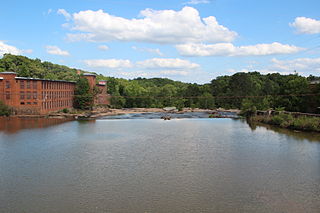
The Yellow River is a 76-mile-long (122 km) tributary of the Ocmulgee River in the U.S. state of Georgia.

12Stone Church is an American Wesleyan multi-site megachurch with multiple locations in Gwinnett County, Georgia. Kevin Myers is the founder and senior pastor of 12Stone.


